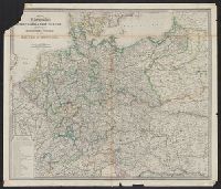
1. Map of the Germanic confederated states : including the kingdoms of Prussia, and the empire of Creator: Wyld, James, 1812-1887 Published / Created: [1875?] Call Number: 36 1875 Container / Volume: BRBL_00120 Image Count: 1 Resource Type: Maps, Atlases & Globes Found in: Beinecke Rare Book and Manuscript Library > Map of the Germanic confederated states : including the kingdoms of Prussia, and the empire of Germany / James Wyld.
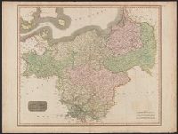
2. Prussian Dominions / drawn and engraved for Thomson's New General atlas. Creator: Thomson, John, active 19th century Call Number: 361 1817 Container / Volume: BRBL_00135 Image Count: 1 Resource Type: Maps, Atlases & Globes Found in: Beinecke Rare Book and Manuscript Library > Prussian Dominions / drawn and engraved for Thomson's New General atlas.