Search
You Searched For
Search Results
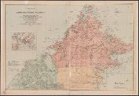
- Creator:
- Edward Stanford Ltd
- Published / Created:
- 1903
- Call Number:
- 2732 1903
- Container / Volume:
- BRBL_00023B
- Image Count:
- 1
- Resource Type:
- Maps, Atlases & Globes
- Description:
- Covers Brunei, Sabah, and northern Sarawak.
- Publisher:
- Published by Edward Stanford for the British North Borneo Company,
- Subject (Geographic):
- Brunei--Maps, Sabah--Maps, and Sarawak--Maps
- Subject (Name):
- British North Borneo Chartered Company
- Found in:
- Beinecke Rare Book and Manuscript Library > A map of British North Borneo / compiled from the English Admiralty charts and from the surveys and explorations of F.X. Witti, W.B. Pryer, F. Hatton, Henry Walker, D.D. Daly, and R.D. Beeston in the service of the British North Borneo Company.
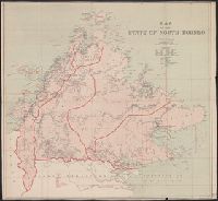
- Creator:
- Edward Stanford Ltd
- Published / Created:
- 1919
- Call Number:
- 2732 1919
- Container / Volume:
- BRBL_00023B
- Image Count:
- 1
- Resource Type:
- Maps, Atlases & Globes
- Alternative Title:
- State of North Borneo
- Description:
- Depths shown by soundings.
- Publisher:
- Stanford's Geographical Establishment,
- Subject (Geographic):
- Sabah--Maps
- Found in:
- Beinecke Rare Book and Manuscript Library > Map of the State of North Borneo, without hills.