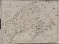
1. A new map of Nova Scotia, and Cape Britain [cartographic material] : With the adjacent parts of New Creator: Lodge, John, -1796 Published / Created: 31st July 1785. Call Number: 732 1785 Container / Volume: BRBL_00376A Image Count: 1 Resource Type: Maps, Atlases & Globes Found in: Beinecke Rare Book and Manuscript Library > A new map of Nova Scotia, and Cape Britain [cartographic material] : With the adjacent parts of New England and Canada, from the latest authorities / J. Lodge sc.
2. An exact chart of the river St. Laurence : from Fort Frontenac to the island of Anticosti shewing Creator: Jefferys, Thomas, d. 1771 Published / Created: 25 May, 1775. Call Number: 7345cea 1775 Container / Volume: BRBL_00689 Image Count: 1 Resource Type: Maps, Atlases & Globes Found in: Beinecke Rare Book and Manuscript Library > An exact chart of the river St. Laurence : from Fort Frontenac to the island of Anticosti shewing the soundings, rocks, shoals & c with views of the lands and all necessary instructions for navigating that river to Quebec / by ... Thos. Jefferys.
3. An exact chart of the river St. Laurence : from Fort Frontenac to the island of Anticosti shewing Creator: Jefferys, Thomas, d. 1771 Published / Created: 25 May, 1775. Call Number: 7345cea 1775 Container / Volume: BRBL_00381 Image Count: 1 Resource Type: Maps, Atlases & Globes Found in: Beinecke Rare Book and Manuscript Library > An exact chart of the river St. Laurence : from Fort Frontenac to the island of Anticosti shewing the soundings, rocks, shoals & c with views of the lands and all necessary instructions for navigating that river to Quebec / by ... Thos. Jefferys.