Search
You Searched For
Search Results
- Creator:
- National Geographic Society (U.S.). Cartographic Division
- Published / Created:
- 1979
- Call Number:
- 738 1979
- Container / Volume:
- BRBL_00387
- Image Count:
- 2
- Resource Type:
- Maps, Atlases & Globes
- Found in:
- Beinecke Rare Book and Manuscript Library > Close-up, Canada, Saskatchewan and Manitoba / produced by the Cartographic Division, National Geographic Society ; Richard J. Darley, chief cartographer ; John F. Shupe, associate chief cartographer.
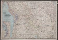
- Creator:
- National Geographic Society (U.S.). Cartographic Section
- Published / Created:
- 1950
- Call Number:
- 80 1950
- Container / Volume:
- BRBL_00536
- Image Count:
- 1
- Resource Type:
- Maps, Atlases & Globes
- Found in:
- Beinecke Rare Book and Manuscript Library > Northwestern United States and neighboring Canadian provinces / compiled and drawn in the Cartographic Section of the National Geographic Society for the National geographic magazine ; James M. Darley, chief cartographer.
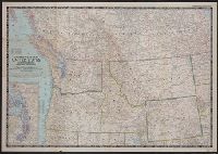
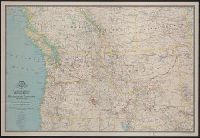
- Creator:
- National Geographic Society (U.S.). Cartographic Section
- Published / Created:
- 1941
- Call Number:
- 80 1941
- Container / Volume:
- BRBL_00536
- Image Count:
- 1
- Resource Type:
- Maps, Atlases & Globes
- Found in:
- Beinecke Rare Book and Manuscript Library > A map of Northwestern United States and neighboring Canadian Provinces / prepared in the Cartographic Section of the National Geographic Society for the National geographic magazine ; James M. Darley, chief cartographer.
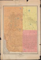
- Published / Created:
- 1925
- Call Number:
- 736 P26 1925
- Container / Volume:
- BRBL_00382
- Image Count:
- 1
- Resource Type:
- Maps, Atlases & Globes
- Found in:
- Beinecke Rare Book and Manuscript Library > Map of The Pas mineral area and adjacent territory to the north, Manitoba and Saskatchewan / ǂc compiled, drawn and printed by the Topographical Survey of Canada.
- Published / Created:
- 1968
- Call Number:
- 736 W73 1968
- Container / Volume:
- BRBL_00382
- Image Count:
- 1
- Resource Type:
- Maps, Atlases & Globes
- Found in:
- Beinecke Rare Book and Manuscript Library > Winnipeg.
- Published / Created:
- 1925
- Call Number:
- 738GC 1924
- Container / Volume:
- BRBL_00387
- Image Count:
- 1
- Resource Type:
- Maps, Atlases & Globes
- Found in:
- Beinecke Rare Book and Manuscript Library > Map of district north and east of Onion Lake, comprising part of Prince Albert Land District.
- Creator:
- Canada. Dept. of the Interior
- Published / Created:
- 1935
- Call Number:
- 738 1935
- Container / Volume:
- BRBL_00387
- Image Count:
- 1
- Resource Type:
- Maps, Atlases & Globes
- Found in:
- Beinecke Rare Book and Manuscript Library > Saskatchewan south / prepared and printed at the Office of the Surveyor General, Ottawa, 1935.
- Creator:
- Canada. Dept. of the Interior
- Published / Created:
- 1903
- Call Number:
- 737 1903
- Container / Volume:
- BRBL_00384
- Image Count:
- 1
- Resource Type:
- Maps, Atlases & Globes
- Found in:
- Beinecke Rare Book and Manuscript Library > Alberta and western portions of Saskatchewan and Assiniboia / James White, Geographer.
- Published / Created:
- [1913]
- Call Number:
- 738 1913
- Container / Volume:
- BRBL_00387
- Image Count:
- 1
- Resource Type:
- Maps, Atlases & Globes
- Found in:
- Beinecke Rare Book and Manuscript Library > Saskatchewan the world's greatest wheat producing region.