Search
You Searched For
Search Results
- Creator:
- H.M. Gousha Company
- Published / Created:
- [1938]
- Call Number:
- 822gmb 1938
- Container / Volume:
- BRBL_00567
- Image Count:
- 2
- Resource Type:
- Maps, Atlases & Globes
- Found in:
- Beinecke Rare Book and Manuscript Library > 1938 official road map, North Dakota, South Dakota / [prepared for] Phillips Petroleum Company.
- Creator:
- H.M. Gousha Company
- Published / Created:
- [1937]
- Call Number:
- 823gmb 1937
- Container / Volume:
- BRBL_00569
- Image Count:
- 2
- Resource Type:
- Maps, Atlases & Globes
- Found in:
- Beinecke Rare Book and Manuscript Library > Cities Service invites you to tour South Dakota.
- Creator:
- Rakowicz, E. H
- Published / Created:
- 1886
- Call Number:
- 821 1886A
- Container / Volume:
- BRBL_00566
- Image Count:
- 2
- Resource Type:
- Maps, Atlases & Globes
- Found in:
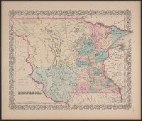
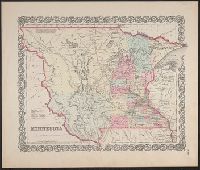
- Beinecke Rare Book and Manuscript Library > Map of the Department of Dakota : including Minnesota, Dakota and Montana / compiled and drawn under the direction of John Biddle by E.H. Rakowicz.
- Published / Created:
- [19--?]
- Call Number:
- 823 19XX
- Container / Volume:
- BRBL_00568
- Image Count:
- 1
- Resource Type:
- Maps, Atlases & Globes
- Found in:
- Beinecke Rare Book and Manuscript Library > Map of the state of South Dakota.
- Creator:
- J.H. Colton & Co
- Published / Created:
- [1855 or 1856?]
- Call Number:
- 814 1855H
- Container / Volume:
- BRBL_00557
- Image Count:
- 1
- Resource Type:
- Maps, Atlases & Globes
- Found in:
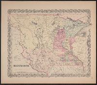
- Beinecke Rare Book and Manuscript Library > Minnesota.
- Creator:
- J.H. Colton & Co
- Published / Created:
- [1855 or 1856?]
- Call Number:
- 814 1855F
- Container / Volume:
- BRBL_00557
- Image Count:
- 1
- Resource Type:
- Maps, Atlases & Globes
- Found in:
- Beinecke Rare Book and Manuscript Library > Minnesota.
- Creator:
- J.H. Colton & Co
- Published / Created:
- [1855 or 1856?]
- Call Number:
- 814 1855G
- Container / Volume:
- BRBL_00557
- Image Count:
- 1
- Resource Type:
- Maps, Atlases & Globes
- Found in:
- Beinecke Rare Book and Manuscript Library > Minnesota.
- Creator:
- J.H. Colton & Co
- Published / Created:
- [1855 or 1856?]
- Call Number:
- 814 1855E
- Container / Volume:
- BRBL_00557
- Image Count:
- 2
- Resource Type:
- Maps, Atlases & Globes
- Found in:
- Beinecke Rare Book and Manuscript Library > Minnesota.
- Published / Created:
- 1889?]
- Call Number:
- 823 1889
- Container / Volume:
- BRBL_00568
- Image Count:
- 1
- Resource Type:
- Maps, Atlases & Globes
- Found in:
- Beinecke Rare Book and Manuscript Library > Official map of South Dakota / issued by the Department of Immigration and Statistics.
- Creator:
- Rand McNally and Company
- Published / Created:
- c1887.
- Call Number:
- 821 1887
- Container / Volume:
- BRBL_00566
- Image Count:
- 1
- Resource Type:
- Maps, Atlases & Globes
- Found in:
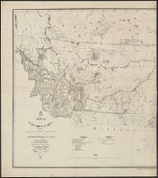
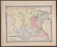
- Beinecke Rare Book and Manuscript Library > Official map of the territory of Dakota.
- Creator:
- H.M. Gousha Company
- Published / Created:
- [1942]
- Call Number:
- 823gmb 1942
- Container / Volume:
- BRBL_00569
- Image Count:
- 2
- Resource Type:
- Maps, Atlases & Globes
- Found in:
- Beinecke Rare Book and Manuscript Library > Official road map of South Dakota / [prepared for] Conoco Travel Bureau.
- Creator:
- Petsch, Bruno C. (Bruno Carl), 1901-
- Published / Created:
- [1947]
- Call Number:
- 823c 1947
- Container / Volume:
- BRBL_00569
- Image Count:
- 1
- Resource Type:
- Maps, Atlases & Globes
- Found in:
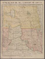
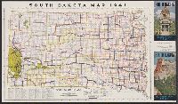
- Beinecke Rare Book and Manuscript Library > Physical features of the state of South Dakota / State Geological Survey, Vermillion, S.D., 1947 ; compiled and drafted by Bruno C. Petsch, Helen C. Lockwood.
- Creator:
- Rand McNally and Company
- Published / Created:
- [1933?]
- Call Number:
- 823gmb 1933
- Container / Volume:
- BRBL_00569
- Image Count:
- 2
- Resource Type:
- Maps, Atlases & Globes
- Found in:
- Beinecke Rare Book and Manuscript Library > Pure Oil pathfinder for South Dakota / with compliments of The Pure Oil Company, U.S.A.
- Creator:
- Rand McNally and Company
- Published / Created:
- 1891
- Call Number:
- 823 1891
- Container / Volume:
- BRBL_00568
- Image Count:
- 1
- Resource Type:
- Maps, Atlases & Globes
- Found in:
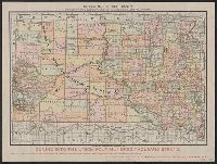
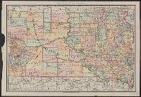
- Beinecke Rare Book and Manuscript Library > Rand McNally & Co.'s South Dakota.
- Creator:
- Rand McNally and Company
- Published / Created:
- c1911.
- Call Number:
- 823 1911
- Container / Volume:
- BRBL_00568
- Image Count:
- 1
- Resource Type:
- Maps, Atlases & Globes
- Found in:
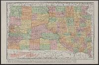
- Beinecke Rare Book and Manuscript Library > Rand McNally & Co.'s South Dakota.
- Published / Created:
- 1876
- Call Number:
- 821 1876A
- Container / Volume:
- BRBL_00566
- Image Count:
- 1
- Resource Type:
- Maps, Atlases & Globes
- Found in:
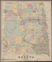
- Beinecke Rare Book and Manuscript Library > Rice's sectional map of Dakota.
- Creator:
- O'Neill, Ralph S
- Published / Created:
- [1941]
- Call Number:
- 823gmb 1941
- Container / Volume:
- BRBL_00569
- Image Count:
- 2
- Resource Type:
- Maps, Atlases & Globes
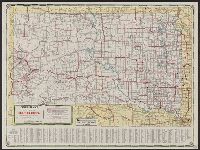
- Found in:
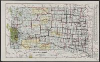
- Beinecke Rare Book and Manuscript Library > South Dakota highways / prepared by the South Dakota State-wide Highway Planning Survey ; drawn by Ralph S. O'Neill, 1939.
- Creator:
- South Dakota. State Highway Commission
- Published / Created:
- [1939]
- Call Number:
- 823gmb 1939
- Container / Volume:
- BRBL_00569
- Image Count:
- 2
- Resource Type:
- Maps, Atlases & Globes
- Found in:
- Beinecke Rare Book and Manuscript Library > South Dakota highways.
- Creator:
- Rand McNally and Company
- Published / Created:
- c1912.
- Call Number:
- 823 1912
- Container / Volume:
- BRBL_00568
- Image Count:
- 1
- Resource Type:
- Maps, Atlases & Globes
- Found in:
- Beinecke Rare Book and Manuscript Library > The Rand McNally new commercial atlas map of South Dakota.
- Creator:
- National Geographic Society (U.S.)
- Published / Created:
- 1936
- Call Number:
- 823am 1936
- Container / Volume:
- BRBL_00569
- Image Count:
- 1
- Resource Type:
- Maps, Atlases & Globes
- Found in:
- Beinecke Rare Book and Manuscript Library > The first photograph ever made showing the division between the troposhere and the stratosphere and also the actual curvature of the earth : photographed from an elevation of 72,395 feet, the highest point ever reached by man.