Search
You Searched For
Search Results
- Call Number:
- Zc20 931pi
- Collection Title:
- Pichardo’s treatise on the limits of Louisiana and Texas : an argumentative historical treatise
- Image Count:
- 1
- Found in:
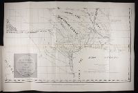
- Beinecke Rare Book and Manuscript Library > Section of Pichardo's map of New Mexico and adjacent regions, drawn in 1811 to assist in the determination of the boundaries between the Spanish dominions and the United States.
- Creator:
- Puelles, José María de Jesus
- Published / Created:
- [ca. 1828?]
- Call Number:
- WA MSS S-1586 P962
- Image Count:
- 1
- Found in:
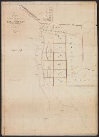
- Beinecke Rare Book and Manuscript Library > Plan de la provincia de Texas
- Creator:
- Staples, Stephen McL. (Stephen McLellan), 1800-1832
- Published / Created:
- 1828
- Call Number:
- 796ad 1828
- Container / Volume:
- BRBL_00716
- Image Count:
- 2
- Resource Type:
- Maps, Atlases & Globes
- Found in:
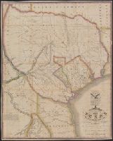
- Beinecke Rare Book and Manuscript Library > A map of northern part of Mexico, including Exter and Wilson's Grant / made from Legrand's notes and other documents by S. McL. Staples, A.M., surveyor general of Chihuahua.
- Creator:
- Austin, Stephen F. (Stephen Fuller), 1793-1836
- Published / Created:
- [1830?]
- Call Number:
- 796 1830
- Container / Volume:
- BRBL_00524
- Image Count:
- 1
- Resource Type:
- Maps, Atlases & Globes
- Found in:
- Beinecke Rare Book and Manuscript Library > Map of Texas with parts of the adjoining states / compiled by Stephen F. Austin ; engraved by John & Wm. W. Warr.
- Published / Created:
- [1833?]
- Call Number:
- 796 1833C
- Container / Volume:
- BRBL_00524
- Image Count:
- 1
- Resource Type:
- Maps, Atlases & Globes
- Found in:
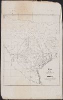
- Beinecke Rare Book and Manuscript Library > Map of the southern part of Texas / E.S. Mesier, lith.
- Published / Created:
- [1833?]
- Call Number:
- 796 1833B
- Container / Volume:
- BRBL_00524
- Image Count:
- 1
- Resource Type:
- Maps, Atlases & Globes
- Found in:
- Beinecke Rare Book and Manuscript Library > Map of the southern part [of] Texas / E.S. Mesier, lith.
- Creator:
- Colorado and Red River Land Company, New York
- Published / Created:
- [1835?]
- Call Number:
- 796 1839A
- Container / Volume:
- BRBL_00524
- Image Count:
- 1
- Resource Type:
- Maps, Atlases & Globes
- Found in:
- Beinecke Rare Book and Manuscript Library > Map of Texas shewing the grants in possession of the Colorado & Red River Land Comp.y.
- Creator:
- Burr, David H., 1803-1875
- Published / Created:
- 1835
- Call Number:
- 796 1835C
- Container / Volume:
- BRBL_00524
- Image Count:
- 1
- Resource Type:
- Maps, Atlases & Globes
- Found in:
- Beinecke Rare Book and Manuscript Library > Texas / by David H. Burr ; engraved by S. Stiles & Co.
- Creator:
- Groves, H
- Published / Created:
- 1837?]
- Call Number:
- 796fb 1837
- Container / Volume:
- BRBL_00530
- Image Count:
- 1
- Resource Type:
- Maps, Atlases & Globes
- Found in:
- Beinecke Rare Book and Manuscript Library > Map of the republic of Texas, shewing its division into counties and latest improvements to 1837 / compiled & written on stone by H. Groves.
- Published / Created:
- 1839?]
- Call Number:
- 796 1839G
- Container / Volume:
- BRBL_00524
- Image Count:
- 1
- Resource Type:
- Maps, Atlases & Globes
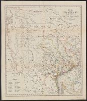
- Found in:
- Beinecke Rare Book and Manuscript Library > Karte von Texas, entworfen nach den Vermessungen der General Land Office der Republic, bis zum Jahr 1839.