Search
You Searched For
Search Results
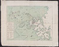
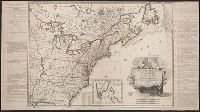
- Creator:
- Le Rouge, Georges-Louis
- Published / Created:
- 1777
- Call Number:
- 755 1777G
- Container / Volume:
- BRBL_00431
- Image Count:
- 1
- Resource Type:
- Maps, Atlases & Globes
- Found in:
- Beinecke Rare Book and Manuscript Library > Theatre de la guerre en Amérique / par le Sr. le Rouge, ingenieur, geographe du Roy.
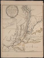
- Creator:
- De Costa, J
- Published / Created:
- July 29th, 1775.
- Call Number:
- 764 B65 1775
- Container / Volume:
- BRBL_00454
- Image Count:
- 1
- Resource Type:
- Maps, Atlases & Globes
- Found in:
- Beinecke Rare Book and Manuscript Library > A plan of the town and harbour of Boston and the country adjacent, with the road from Boston to Concord : shewing the place of the late engagement between the King's troops & the provincials, together with the several encampments of both armies in & about
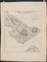
- Creator:
- Page, Thomas Hyde, Sir, 1746-1821
- Published / Created:
- [1775]
- Call Number:
- 764 B65 1775C
- Container / Volume:
- BRBL_00454
- Image Count:
- 1
- Resource Type:
- Maps, Atlases & Globes
- Found in:
- Beinecke Rare Book and Manuscript Library > A plan of the action at Bunkers-Hill, on the 17th. of June, 1775, between His Majesty's troops under the command of Major General Howe, and the rebel forces, by Lieut. Page, of the Engineers, who acted as aide de camp to General Howe in that action.
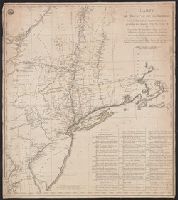
- Published / Created:
- 1776
- Call Number:
- 771hc 1776B
- Container / Volume:
- BRBL_00495
- Image Count:
- 1
- Resource Type:
- Maps, Atlases & Globes
- Found in:
- Beinecke Rare Book and Manuscript Library > The Seat of Action between the British and American Forces ... the Western part of Long Island ... Staten Island ... Amboy and New York ... Hudson's river from Courtland to Sandy Hook .... Surveys of Major Holland.
- Creator:
- Capitaine du Chesnoy, Michel, 1746-1804
- Published / Created:
- [1779]
- Call Number:
- 755 1775C
- Container / Volume:
- BRBL_00429
- Image Count:
- 1
- Resource Type:
- Maps, Atlases & Globes
- Found in:
- Beinecke Rare Book and Manuscript Library > Carte du théatre de la guerre dans l'Amerique Septentrionale pendant les années 1775, 76, 77, et 78 [cartographic material] : où se trouvent les principaux camps avec les différentes places et epoques des batailles qui se sont données pendent ces cam
- Published / Created:
- 1776
- Call Number:
- 771hc 1776
- Container / Volume:
- BRBL_00714
- Image Count:
- 1
- Resource Type:
- Maps, Atlases & Globes
- Found in:
- Beinecke Rare Book and Manuscript Library > Plan of the Operations of the British army in North America, Commanded by General Howe from the 15th to the 16th Nov. 1776.
- Creator:
- Bonne, Rigobert, 1727-1794
- Published / Created:
- [1776?]
- Call Number:
- 71 1776C
- Container / Volume:
- BRBL_00365
- Image Count:
- 1
- Resource Type:
- Maps, Atlases & Globes
- Found in:
- Beinecke Rare Book and Manuscript Library > Partie de l'Amerique septentrionale : qui comprend le Canada, la Louisiane, le Labrador, le Groenland, la Nouvelle Angleterre, la Floride &c. / projettée et assujettie aux observations, par Mr. Bonne.
- Creator:
- Lattré, Jean
- Published / Created:
- 1784
- Call Number:
- 75 1784
- Container / Volume:
- BRBL_00396
- Image Count:
- 1
- Resource Type:
- Maps, Atlases & Globes
- Found in:
- Beinecke Rare Book and Manuscript Library > Carte des Etats-Unis de l'Amerique suivant le Traité de Paix de 1783 : dédiée et présentée a s. excellence Mr. Benjamin Franklin... / par son très humble et très obeissant Serviteur Lattré.