Search
You Searched For
Search Results
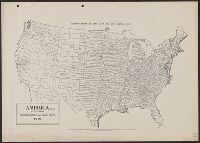
- Creator:
- United States. Congress. House. Committee on the Public Lands
- Published / Created:
- [1878?].
- Call Number:
- 75 1878
- Container / Volume:
- BRBL_00406
- Image Count:
- 16
- Resource Type:
- Maps, Atlases & Globes
- Found in:
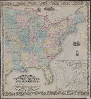
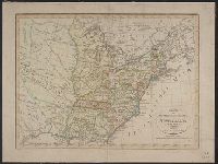
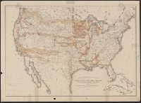
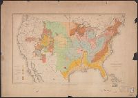
- Beinecke Rare Book and Manuscript Library > 1876 Centennial map of the United States and territories : showing the extent of public surveys, indian and military reservations, land grant R.R. rail roads, canals, cities, towns & other details / compiled from the official surveys of the General Land O
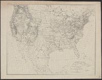
- Published / Created:
- 1810?]
- Call Number:
- 75 1810A
- Container / Volume:
- BRBL_00396
- Image Count:
- 1
- Resource Type:
- Maps, Atlases & Globes
- Found in:
- Beinecke Rare Book and Manuscript Library > A correct map of the United States of North America. Including the British and Spanish territories carefully laid down agreeable to the treaty of 1784. By T. Bowen, Geogr.
- Published / Created:
- March 15, 1832
- Call Number:
- 75 1850
- Container / Volume:
- BRBL_00689
- Image Count:
- 2
- Resource Type:
- Maps, Atlases & Globes
- Found in:
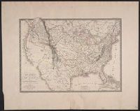
- Beinecke Rare Book and Manuscript Library > A geological map of the United States [cartographic material].
- Creator:
- Allen, F. D
- Published / Created:
- [1813]
- Call Number:
- 71 1813A
- Container / Volume:
- BRBL_00368
- Image Count:
- 1
- Resource Type:
- Maps, Atlases & Globes
- Found in:
- Beinecke Rare Book and Manuscript Library > A map of the British possessions in North America, including part of the United States / by F.D. Allen, 1815 ; J. Lewis sculpt.
- Published / Created:
- [185-]
- Call Number:
- 754gme 1850C
- Container / Volume:
- BRBL_00419
- Image Count:
- 1
- Resource Type:
- Maps, Atlases & Globes
- Found in:
- Beinecke Rare Book and Manuscript Library > A map of the North Western Rail Way : passing thr'o [sic] the Lackawanna Coal Lands in Pennsylvania / by James Seymour.
- Creator:
- Shelton & Kensett
- Published / Created:
- [1816]
- Call Number:
- 75 1816
- Container / Volume:
- BRBL_00397
- Image Count:
- 4
- Resource Type:
- Maps, Atlases & Globes
- Found in:
- Beinecke Rare Book and Manuscript Library > A map of the United States and British provinces of Upper and Lower Canada with other parts adjacent [cartographic material] / by Shelton & Kensett.
- Published / Created:
- 1841
- Call Number:
- 75 1841
- Container / Volume:
- BRBL_00399
- Image Count:
- 1
- Resource Type:
- Maps, Atlases & Globes
- Found in:
- Beinecke Rare Book and Manuscript Library > A map of the United States from the latest surverys - with the height of mountains and length of principal rivers. Engraved by G.W. Beynton.
- Creator:
- Tanner, Henry Schenck, 1786-1858
- Published / Created:
- [1839?]
- Call Number:
- G1200 T34 1839 (LC)
- Image Count:
- 4
- Resource Type:
- Maps, Atlases & Globes
- Found in:
- Beinecke Rare Book and Manuscript Library > A new American atlas [cartographic material] : containing maps of the several states of the North American union ... / by Henry S. Tanner.
- Published / Created:
- 1857
- Call Number:
- 75gme 1857
- Container / Volume:
- BRBL_00412
- Image Count:
- 2
- Resource Type:
- Maps, Atlases & Globes
- Found in:
- Beinecke Rare Book and Manuscript Library > A new and complete Rail Road map of the United States / compiled from reliable sources by William Perris ; presented by the Home Insurance Company of New York ; Korff Brothers, Practical Lithographers, New York.
- Creator:
- Smith, J. Calvin (John Calvin)
- Published / Created:
- 1870, c1856.
- Call Number:
- 75 1870S
- Container / Volume:
- BRBL_00404
- Image Count:
- 1
- Resource Type:
- Maps, Atlases & Globes
- Found in:
- Beinecke Rare Book and Manuscript Library > A new map for travelers through the United States of America showing the railroads, canals & stage roads with the distances / by J. Calvin Smith ; eng. on steel by Sherman & Smith, N.Y.
- Published / Created:
- 1850
- Call Number:
- 75GM 1850B
- Container / Volume:
- BRBL_00410
- Image Count:
- 1
- Resource Type:
- Maps, Atlases & Globes
- Found in:
- Beinecke Rare Book and Manuscript Library > A new map for travellers through the United States of America showing the railways, canals & stage roads with the distances.
- Creator:
- Beadle, E. F
- Published / Created:
- [1856?]
- Call Number:
- 80gme 1856B
- Container / Volume:
- BRBL_00538
- Image Count:
- 1
- Resource Type:
- Maps, Atlases & Globes
- Found in:
- Beinecke Rare Book and Manuscript Library > A new map of the Great West.
- Creator:
- Young, J. H. (James Hamilton)
- Published / Created:
- 1857
- Call Number:
- 75 1857
- Container / Volume:
- BRBL_00401
- Image Count:
- 1
- Resource Type:
- Maps, Atlases & Globes
- Found in:
- Beinecke Rare Book and Manuscript Library > A new map of the United States of America / by J.H. Young ; engraved by J.L. Hazzard & E. Yeager.
- Creator:
- Young, J. H. (James Hamilton)
- Published / Created:
- 1860, c1859.
- Call Number:
- 75 1859D
- Container / Volume:
- BRBL_00401
- Image Count:
- 1
- Resource Type:
- Maps, Atlases & Globes
- Found in:
- Beinecke Rare Book and Manuscript Library > A new map of the United States of America / by J.H. Young ; engraved by J.L. Hazzard & E. Yeager.
- Published / Created:
- 1861
- Call Number:
- 75 1861N
- Container / Volume:
- BRBL_00402
- Image Count:
- 1
- Resource Type:
- Maps, Atlases & Globes
- Found in:
- Beinecke Rare Book and Manuscript Library > A new map of the United States of America / by J.H. Young.
- Creator:
- Young, J. H. (James Hamilton)
- Published / Created:
- [1864]
- Call Number:
- 75 1864B
- Container / Volume:
- BRBL_00403
- Image Count:
- 1
- Resource Type:
- Maps, Atlases & Globes
- Found in:
- Beinecke Rare Book and Manuscript Library > A new map of the United States of America [cartographic material] / by J.H. Young ; engraved by J.L. Hazzard & E. Yeager.
- Creator:
- Young, J. H. (James Hamilton)
- Published / Created:
- [1864]
- Call Number:
- 75 1864B
- Container / Volume:
- BRBL_00403
- Image Count:
- 2
- Resource Type:
- Maps, Atlases & Globes
- Found in:
- Beinecke Rare Book and Manuscript Library > A new map of the United States of America [cartographic material] / by J.H. Young ; engraved by J.L. Hazzard & E. Yeager.
- Creator:
- Williams, W. (Wellington)
- Published / Created:
- 1851
- Call Number:
- 75 1851
- Container / Volume:
- BRBL_00400
- Image Count:
- 1
- Resource Type:
- Maps, Atlases & Globes
- Found in:
- Beinecke Rare Book and Manuscript Library > A new map of the United States. Upon which are delineated its vast works of internal communication, routes across the continent &c. showing also Canada and the Island of Cuba, by W. Williams.
- Published / Created:
- 1928
- Call Number:
- 75GMR 1928
- Container / Volume:
- BRBL_00414A
- Image Count:
- 1
- Resource Type:
- Maps, Atlases & Globes
- Found in:
- Beinecke Rare Book and Manuscript Library > Air Mail Services To & From New York.
- Published / Created:
- [1874?].
- Call Number:
- 75gma 1874
- Container / Volume:
- BRBL_00411
- Image Count:
- 1
- Resource Type:
- Maps, Atlases & Globes
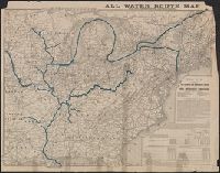
- Found in:
- Beinecke Rare Book and Manuscript Library > All water route map from the Mississippi to the Eastern Atlantic / [Printed for] The Illinois and Mississippi River and Canal Improvement Commission, Davenport, Iowa.
- Creator:
- Goode, J. Paul, 1862-1932
- Published / Created:
- c1910.
- Call Number:
- 75fb 1910A
- Container / Volume:
- BRBL_00410
- Image Count:
- 1
- Resource Type:
- Maps, Atlases & Globes
- Found in:
- Beinecke Rare Book and Manuscript Library > America (U.S.) by counties.
- Published / Created:
- 1863-1864.
- Call Number:
- 75cea 1864
- Container / Volume:
- BRBL_00409
- Image Count:
- 2
- Resource Type:
- Maps, Atlases & Globes
- Found in:
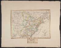
- Beinecke Rare Book and Manuscript Library > Atlantic Coast of the United States (in four sheets).
- Creator:
- U.S. Coast and Geodetic Survey
- Published / Created:
- 1880
- Call Number:
- 75AK 1880
- Container / Volume:
- BRBL_00407A
- Image Count:
- 1
- Resource Type:
- Maps, Atlases & Globes
- Found in:
- Beinecke Rare Book and Manuscript Library > Base-map of the United States / Drawn and engraved by A. and H. Lindenkohl.
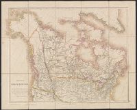
- Creator:
- Arrowsmith, John, 1790-1873
- Published / Created:
- 25 April 1859.
- Call Number:
- 73 1859D
- Container / Volume:
- BRBL_00375
- Image Count:
- 2
- Resource Type:
- Maps, Atlases & Globes
- Found in:
- Beinecke Rare Book and Manuscript Library > British North America : by permission dedicated to the Honble. Hudsons Bay Company, containing the latest information which their documents furnish / by their obedient servant, J. Arrowsmith.
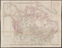
- Creator:
- Arrowsmith, John, 1790-1873
- Published / Created:
- 1832 February 15
- Call Number:
- 73 1832
- Container / Volume:
- BRBL_00374
- Image Count:
- 1
- Resource Type:
- Maps, Atlases & Globes
- Found in:
- Beinecke Rare Book and Manuscript Library > British North America : by permission dedicated to the Honble. Hudsons Bay Company, containing the latest information which their documents furnish / by their obedient servant, J. Arrowsmith.
- Published / Created:
- 1968
- Call Number:
- 75 1868A
- Container / Volume:
- BRBL_00404
- Image Count:
- 2
- Resource Type:
- Maps, Atlases & Globes
- Found in:
- Beinecke Rare Book and Manuscript Library > Cabinet Map of the United States and Territories / compiled from government maps and published by Rufus Blanchard.
- Published / Created:
- 1820
- Call Number:
- 75 1820B
- Container / Volume:
- BRBL_00397
- Image Count:
- 1
- Resource Type:
- Maps, Atlases & Globes
- Found in:
- Beinecke Rare Book and Manuscript Library > Carte Generale des États-Unis ... par A.H. Brué Geographe ... Gravée Sous la direction de Auteur.
- Published / Created:
- 1825
- Call Number:
- 75 1825
- Container / Volume:
- BRBL_00398
- Image Count:
- 1
- Resource Type:
- Maps, Atlases & Globes
- Found in:
- Beinecke Rare Book and Manuscript Library > Carte Generale des États-Unis, du Canada ... par A. Brué, Géographe du Roi. Gravée sous la direction de l'Auteur.
- Published / Created:
- 1825
- Call Number:
- 75J 1825
- Container / Volume:
- BRBL_00414A
- Image Count:
- 1
- Resource Type:
- Maps, Atlases & Globes
- Found in:
- Beinecke Rare Book and Manuscript Library > Carte de l'adjonction progressive des divers états au territoire et à l'union constitutionnelle des Etats-Unis de L'Amerique du Nord.
- Creator:
- Levasseur, Emile, 1828-1911
- Published / Created:
- [1875]
- Call Number:
- 85 1875
- Container / Volume:
- BRBL_00638
- Image Count:
- 1
- Resource Type:
- Maps, Atlases & Globes
- Found in:
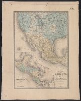
- Beinecke Rare Book and Manuscript Library > Carte générale du Mexique : et de la partie Sud-Ouest des Etats-Unis / Dressée par A. Brué, Géographe ; Revue par E. Levasseur.
- Published / Created:
- 1820
- Call Number:
- 75 1820
- Container / Volume:
- BRBL_00397
- Image Count:
- 1
- Resource Type:
- Maps, Atlases & Globes
- Found in:
- Beinecke Rare Book and Manuscript Library > Charte von den Vereinigten Staaten von Nord America mit Luisiana.
- Published / Created:
- 1809
- Call Number:
- 75 1809
- Container / Volume:
- BRBL_00396
- Image Count:
- 1
- Resource Type:
- Maps, Atlases & Globes
- Found in:
- Beinecke Rare Book and Manuscript Library > Charte von den Vereinigten Staaten von Nord America mit Luisiana.
- Published / Created:
- 1855
- Call Number:
- 75 1855B
- Container / Volume:
- BRBL_00401
- Image Count:
- 2
- Resource Type:
- Maps, Atlases & Globes
- Found in:
- Beinecke Rare Book and Manuscript Library > Colton's United States of America / published by J.H. Colton.
- Creator:
- G.W. & C.B. Colton & Co
- Published / Created:
- 1869
- Call Number:
- 75 1869A
- Container / Volume:
- BRBL_00404
- Image Count:
- 2
- Resource Type:
- Maps, Atlases & Globes
- Found in:
- Beinecke Rare Book and Manuscript Library > Colton's map of the United States of America, the British provinces, Mexico and the West Indies : showing the country from the Atlantic to the Pacific Ocean.
- Creator:
- G.W. & C.B. Colton & Co
- Published / Created:
- 1864
- Call Number:
- 75 1864
- Container / Volume:
- BRBL_00403
- Image Count:
- 1
- Resource Type:
- Maps, Atlases & Globes
- Found in:
- Beinecke Rare Book and Manuscript Library > Coltons' rail-road and military map of the United States, Mexico, the West Indies &c.
- Creator:
- Burr, Henry A
- Published / Created:
- 1853
- Call Number:
- 75GM 1853
- Container / Volume:
- BRBL_00410
- Image Count:
- 1
- Resource Type:
- Maps, Atlases & Globes
- Found in:
- Beinecke Rare Book and Manuscript Library > Disturnell's new map of the United States and Canada : showing all the canals, rail roads, telegraph lines and principal stage routes / Drawn by Henry A. Burr.
- Creator:
- Burr, Henry A
- Published / Created:
- 1850
- Call Number:
- 75 1850
- Container / Volume:
- BRBL_00400
- Image Count:
- 2
- Resource Type:
- Maps, Atlases & Globes
- Found in:
- Beinecke Rare Book and Manuscript Library > Disturnell's new map of the United States and Canada : showing all the canals, rail roads, telegraph lines and principal stage routes / drawn by Henry A. Burr, topographer to the Post Office Dep't., Washington, D.C. ; engraved by J.M. Atwood, N.Y.
- Published / Created:
- 1874]
- Call Number:
- 75eha 1873
- Image Count:
- 1
- Resource Type:
- Maps, Atlases & Globes
- Found in:
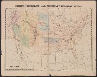
- Beinecke Rare Book and Manuscript Library > Domestic missionary map, Protestant Episcopal Church.
- Published / Created:
- 1834]
- Call Number:
- 75 1834E
- Container / Volume:
- BRBL_00398
- Image Count:
- 1
- Resource Type:
- Maps, Atlases & Globes
- Found in:
- Beinecke Rare Book and Manuscript Library > Estados Unidos de la América Septentrional / Pablo Alabern lo grabo 1834.
- Published / Created:
- [1812?]
- Call Number:
- 75 1812B
- Container / Volume:
- BRBL_00396
- Image Count:
- 1
- Resource Type:
- Maps, Atlases & Globes
- Found in:
- Beinecke Rare Book and Manuscript Library > Etats Unis et Grandes Antilles. Gravé par Chamouin Rue de la Harpe. No. 35. Ecrit par Giraldon.
- Creator:
- Colton, G. Woolworth (George Woolworth), 1827-1901
- Published / Created:
- 1862, c1861.
- Call Number:
- 75 1862C
- Container / Volume:
- BRBL_00403
- Image Count:
- 1
- Resource Type:
- Maps, Atlases & Globes
- Found in:
- Beinecke Rare Book and Manuscript Library > G. Woolworth Colton's new guide map of the United States & Canada : with railroads, counties etc. / drawn, engraved & published by G. Woolworth Colton.
- Creator:
- Colton, G. Woolworth (George Woolworth), 1827-1901
- Published / Created:
- 1877, c1876.
- Call Number:
- 75 1877
- Container / Volume:
- BRBL_00405
- Image Count:
- 1
- Resource Type:
- Maps, Atlases & Globes
- Found in:
- Beinecke Rare Book and Manuscript Library > G. Woolworth Colton's new guide map of the United States & Canada, with railroads, counties, etc.
- Published / Created:
- [1880?].
- Call Number:
- 75gme 1880M
- Container / Volume:
- BRBL_00413
- Image Count:
- 1
- Resource Type:
- Maps, Atlases & Globes
- Found in:
- Beinecke Rare Book and Manuscript Library > General railroad map of the United States and Canada, showing the Macon & Brunswick Railroad and its connections.
- Published / Created:
- 1849
- Call Number:
- 75 1849
- Container / Volume:
- BRBL_00400
- Image Count:
- 1
- Resource Type:
- Maps, Atlases & Globes
- Found in:
- Beinecke Rare Book and Manuscript Library > General-karte der Vereinigten Staaten von Nord-Amerika nebst den grösst theilen von Canada & Tejas ... von Albrecht Platt.
- Creator:
- Goldthwait, J. H
- Published / Created:
- 1861
- Call Number:
- 75 1861D
- Container / Volume:
- BRBL_00402
- Image Count:
- 1
- Resource Type:
- Maps, Atlases & Globes
- Found in:
- Beinecke Rare Book and Manuscript Library > Goldthwait's map of the United States & Canada : exhibiting the railroads with their distances, single and double tracks and width of gauge, and the time compared with noon at Washington & Greenwich / by J.H. Goldthwait.
- Creator:
- C.S. Hammond & Company
- Published / Created:
- [19--?]
- Call Number:
- 75J 1960
- Container / Volume:
- BRBL_00414A
- Image Count:
- 2
- Resource Type:
- Maps, Atlases & Globes
- Found in:
- Beinecke Rare Book and Manuscript Library > Hammond's Map of the United States with historical maps, historical data on states and territories, air line distances and population of cities and towns / compiled and printed expressly for Liggett's, the Rexall Drug Stores.
- Published / Created:
- 1899
- Call Number:
- 807gmb 1899
- Container / Volume:
- BRBL_00551
- Image Count:
- 1
- Resource Type:
- Maps, Atlases & Globes
- Found in:
- Beinecke Rare Book and Manuscript Library > Illinois Central Railroad : and Yazoo & Mississippi Valley Railroad.
- Published / Created:
- [1919?]
- Call Number:
- 75ED 1818B
- Container / Volume:
- BRBL_00410
- Image Count:
- 1
- Resource Type:
- Maps, Atlases & Globes
- Found in:
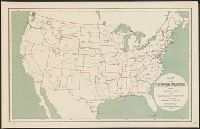
- Beinecke Rare Book and Manuscript Library > Indian Tribes of the Southeastern United States. Compiled by J.R. Swanton, 1919.
- Creator:
- United States. Office of Farm Management
- Published / Created:
- 1915
- Call Number:
- 75gce 1915
- Container / Volume:
- BRBL_00410
- Image Count:
- 1
- Resource Type:
- Maps, Atlases & Globes
- Found in:
- Beinecke Rare Book and Manuscript Library > Irrigation map of the United States / engraved and printed by the U.S. Geological Survey ; outline of irrigated areas based upon data collected by the Bureau of the Census, 1910 ; revised by Irrigation Division, Office of Experimental Stations, and by the
- Creator:
- Johnson, A. J. (Alvin Jewett), 1827-1884
- Published / Created:
- [1864]
- Call Number:
- 75 1864E
- Container / Volume:
- BRBL_00403
- Image Count:
- 1
- Resource Type:
- Maps, Atlases & Globes
- Found in:
- Beinecke Rare Book and Manuscript Library > Johnson's United States.
- Published / Created:
- 1860, c1856.
- Call Number:
- 75 1860
- Container / Volume:
- BRBL_00402
- Image Count:
- 6
- Resource Type:
- Maps, Atlases & Globes
- Found in:
- Beinecke Rare Book and Manuscript Library > Johnson's new illustrated & embellished county map of the Republics of North America : with the adjacent islands & countries / compiled, drawn & engraved from U. States land & coast surveys, British Admiralty & other reliable [sources] under the direction
- Published / Created:
- [1848]
- Call Number:
- 75EG 1848F
- Container / Volume:
- BRBL_00410
- Image Count:
- 1
- Resource Type:
- Maps, Atlases & Globes
- Found in:
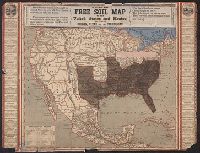
- Beinecke Rare Book and Manuscript Library > Lewis free soil map of the United States and Mexico including Oregon, Texas and the Californias.
- Published / Created:
- 1848
- Call Number:
- 75EG 1848L
- Container / Volume:
- BRBL_00410
- Image Count:
- 1
- Resource Type:
- Maps, Atlases & Globes
- Found in:
- Beinecke Rare Book and Manuscript Library > Lewis' free soil, slavery, and territorial map of the United States.
- Published / Created:
- 1919, c1918.
- Call Number:
- 75gm 1918A
- Container / Volume:
- BRBL_00411
- Image Count:
- 1
- Resource Type:
- Maps, Atlases & Globes
- Found in:
- Beinecke Rare Book and Manuscript Library > Lines of Transportation / compiled and drawn by R. Baxter Blair.
- Creator:
- H.H. Lloyd & Co
- Published / Created:
- 1861
- Call Number:
- 777hc 1861
- Container / Volume:
- BRBL_00504A
- Image Count:
- 1
- Resource Type:
- Maps, Atlases & Globes
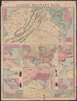
- Found in:
- Beinecke Rare Book and Manuscript Library > Lloyd's military maps : showing the principal places of interest / compiled from official data by Egbert L. Viele and Charles Haskins.
- Published / Created:
- 1866
- Call Number:
- 75CKB 1870M
- Container / Volume:
- BRBL_00409
- Image Count:
- 1
- Resource Type:
- Maps, Atlases & Globes
- Found in:
- Beinecke Rare Book and Manuscript Library > Magnetic Declination : Isogonic lines for the year 1870 / Drawn by A. Lindenkohl ; Chas. G. Krebs, Lith.
- Published / Created:
- 1848.]
- Call Number:
- 75 1848U
- Container / Volume:
- BRBL_00399
- Image Count:
- 1
- Resource Type:
- Maps, Atlases & Globes
- Found in:
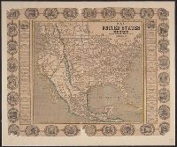
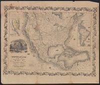
- Beinecke Rare Book and Manuscript Library > Map o f the United States and Mexico including Oregon, Texas and the Californias.
- Published / Created:
- [1880?].
- Call Number:
- 75gme 1880R
- Container / Volume:
- BRBL_00413
- Image Count:
- 1
- Resource Type:
- Maps, Atlases & Globes
- Found in:
- Beinecke Rare Book and Manuscript Library > Map of Michigan, Southern & Northern Indiana Railroad : with their connections from Council Bluffs to New York.
- Creator:
- Poole Brothers
- Published / Created:
- [1927], c1911.
- Call Number:
- 73gme 1927
- Container / Volume:
- BRBL_00376
- Image Count:
- 1
- Resource Type:
- Maps, Atlases & Globes
- Found in:
- Beinecke Rare Book and Manuscript Library > Map of the Canadian Pacific Railway, the Minneapolis, St. Paul & Sault Ste. Marie Railway, the Duluth, South Shore & Atlantic Railway, the Spokane International Railway and connections / Poole Bros, Chicago.
- Creator:
- Poole Brothers
- Published / Created:
- [1901?], c1893.
- Call Number:
- 73eu 1901
- Container / Volume:
- BRBL_00375B
- Image Count:
- 1
- Resource Type:
- Maps, Atlases & Globes
- Found in:
- Beinecke Rare Book and Manuscript Library > Map of the Canadian Pacific Railway, the Minneapolis, St. Paul and Sault Ste. Marie Railway, the Duluth, South Shore and Atlantic Railway and connections / Poole Bros, engravers.
- Published / Created:
- 1907
- Call Number:
- 75gme 1907
- Container / Volume:
- BRBL_00414
- Image Count:
- 1
- Resource Type:
- Maps, Atlases & Globes
- Found in:
- Beinecke Rare Book and Manuscript Library > Map of the Chicago, St. Paul, Minneapolis & Omaha Ry. and Chicago & North Western Ry.
- Published / Created:
- [1855?].
- Call Number:
- 75gme 1855
- Container / Volume:
- BRBL_00411
- Image Count:
- 1
- Resource Type:
- Maps, Atlases & Globes
- Found in:
- Beinecke Rare Book and Manuscript Library > Map of the Clinton Line Railroad and its connections.
- Published / Created:
- 1848
- Call Number:
- 75 1848V
- Container / Volume:
- BRBL_00399
- Image Count:
- 1
- Resource Type:
- Maps, Atlases & Globes
- Found in:
- Beinecke Rare Book and Manuscript Library > Map of the Country between the Atlantic & Pacific Oceans ... shewing the proposed Route of a Rail Road from Mississippi Valley to the parts of St. Diego, Monterey, & San Francisco on the Pacific Coast also the connection of this Road with those of the Atl
- Published / Created:
- 1853
- Call Number:
- 754gme 1853
- Container / Volume:
- BRBL_00419
- Image Count:
- 1
- Resource Type:
- Maps, Atlases & Globes
- Found in:
- Beinecke Rare Book and Manuscript Library > Map of the Delaware, Lackawanna & Western railroad : with its principal connections.
- Published / Created:
- 1891
- Call Number:
- 75gme 1891A
- Container / Volume:
- BRBL_00414
- Image Count:
- 2
- Resource Type:
- Maps, Atlases & Globes
- Found in:
- Beinecke Rare Book and Manuscript Library > Map of the Lake Shore & Michigan Southern Railway "Lake Shore Route" and Principal Connections / Poole Bros., Map Engravers, Chicago.
- Creator:
- J.H. Colton & Co.
- Published / Created:
- 1858
- Call Number:
- 754gme 1858
- Container / Volume:
- BRBL_00420
- Image Count:
- 1
- Resource Type:
- Maps, Atlases & Globes
- Found in:
- Beinecke Rare Book and Manuscript Library > Map of the Mississippi and Missouri Railroad : and its connections.
- Published / Created:
- 1870
- Call Number:
- 80 1870B
- Container / Volume:
- BRBL_00535
- Image Count:
- 1
- Resource Type:
- Maps, Atlases & Globes
- Found in:
- Beinecke Rare Book and Manuscript Library > Map of the North West : from explorations by the United States Engineers & Royal Engineers of England and Union & Northern Pacific R.R. surveys.
- Published / Created:
- [1912?].
- Call Number:
- 75gme 1912
- Container / Volume:
- BRBL_00414A
- Image Count:
- 2
- Resource Type:
- Maps, Atlases & Globes
- Found in:
- Beinecke Rare Book and Manuscript Library > Map of the Pennsylvania System of Railroads and their connections / issued by Passenger Department, Pennsylvania Lines, Pittsburgh, Pa.
- Published / Created:
- 1848
- Call Number:
- 75 1848A
- Container / Volume:
- BRBL_00399
- Image Count:
- 1
- Resource Type:
- Maps, Atlases & Globes
- Found in:
- Beinecke Rare Book and Manuscript Library > Map of the United States & Mexico.
- Published / Created:
- 1831
- Call Number:
- 75 1831A
- Container / Volume:
- BRBL_00398
- Image Count:
- 1
- Resource Type:
- Maps, Atlases & Globes
- Found in:
- Beinecke Rare Book and Manuscript Library > Map of the United States ... J.H. Young Sc.
- Published / Created:
- 1903
- Call Number:
- 75 1903
- Container / Volume:
- BRBL_00407
- Image Count:
- 2
- Resource Type:
- Maps, Atlases & Globes
- Found in:
- Beinecke Rare Book and Manuscript Library > Map of the United States / by Geo. F. Cram.
- Creator:
- Waddell, J. H. (John Hunter)
- Published / Created:
- 1868
- Call Number:
- 75GBC 1868
- Container / Volume:
- BRBL_00410
- Image Count:
- 1
- Resource Type:
- Maps, Atlases & Globes
- Found in:
- Beinecke Rare Book and Manuscript Library > Map of the United States / constructed on the rectangular tangential projection by J.H. Waddell ... ; prepared under the instructions M. F. Maury ...
- Creator:
- Waddell, J. H
- Published / Created:
- 1868?]
- Call Number:
- 75 1868
- Container / Volume:
- BRBL_00404
- Image Count:
- 1
- Resource Type:
- Maps, Atlases & Globes
- Found in:
- Beinecke Rare Book and Manuscript Library > Map of the United States / constructed on the rectangular tangential projection by J.H. Waddell ... ; prepared under the instructions M.F. Maury ...
- Creator:
- Winship, W. W
- Published / Created:
- 1889
- Call Number:
- 75 1889
- Container / Volume:
- BRBL_00407
- Image Count:
- 4
- Resource Type:
- Maps, Atlases & Globes
- Found in:
- Beinecke Rare Book and Manuscript Library > Map of the United States / prepared in the Office of the Chief of Engineers, U.S.A., by W.W. Winship, under the direction of Brig. Gen. John Newton, Chief of Eng., Bvt. Major General, U.S.A.
- Creator:
- Huntington, Eleazer, 1789-1852
- Published / Created:
- 1833
- Call Number:
- 75 1833
- Container / Volume:
- BRBL_00398
- Image Count:
- 1
- Resource Type:
- Maps, Atlases & Globes
- Found in:
- Beinecke Rare Book and Manuscript Library > Map of the United States : corrected from the most authentic sources and published for Darby and Dwight's Gazetteer.
- Published / Created:
- 1826
- Call Number:
- 75 1826B
- Container / Volume:
- BRBL_00398
- Image Count:
- 1
- Resource Type:
- Maps, Atlases & Globes
- Found in:
- Beinecke Rare Book and Manuscript Library > Map of the United States : drawn from the most approved surveys.
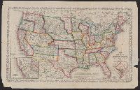
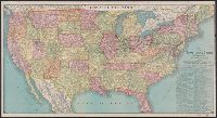
- Published / Created:
- 1878
- Call Number:
- 75GM 1878
- Container / Volume:
- BRBL_00410
- Image Count:
- 1
- Resource Type:
- Maps, Atlases & Globes
- Found in:
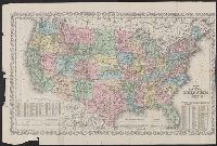
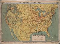
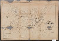
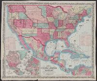
- Beinecke Rare Book and Manuscript Library > Map of the United States : exhibiting the grants of lands made by the General government to aid the construction of railroads and wagon roads / Dept. of the Interior. U.S. Geographical and Geological Survey of the Rocky Mountain Region J.W. Powell, in Cha
- Published / Created:
- 1878
- Call Number:
- 75gme 1878
- Container / Volume:
- BRBL_00412
- Image Count:
- 1
- Resource Type:
- Maps, Atlases & Globes
- Found in:
- Beinecke Rare Book and Manuscript Library > Map of the United States : exhibiting the grants of lands made by the General government to aid the construction of railroads and wagon roads / Dept. of the Interior. U.S. Geographical and Geological Survey of the Rocky Mountain Region J.W. Powell, in Cha
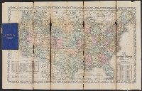
- Published / Created:
- 1849
- Call Number:
- 75 1849F
- Container / Volume:
- BRBL_00400
- Image Count:
- 1
- Resource Type:
- Maps, Atlases & Globes
- Found in:
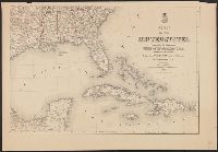
- Beinecke Rare Book and Manuscript Library > Map of the United States Mexico &c. Showing the various Land and Water Routes from the Atlantic Cities to California. Compiled by J.H. Colton for "Last Leaves of American History."
- Published / Created:
- c1883.
- Call Number:
- 75gme 1883A
- Container / Volume:
- BRBL_00413
- Image Count:
- 2
- Resource Type:
- Maps, Atlases & Globes
- Found in:
- Beinecke Rare Book and Manuscript Library > Map of the United States and Canada : showing routes and ticketing facilities of the American Exchange Travelers' Bureau, in connection with the American Exchange in Europe (Limited) / Eng'd by the American Bank Note Co., New York.
- Creator:
- Butterfield, Carlos
- Published / Created:
- [1859]
- Call Number:
- 75 1859
- Container / Volume:
- BRBL_00401
- Image Count:
- 1
- Resource Type:
- Maps, Atlases & Globes
- Found in:
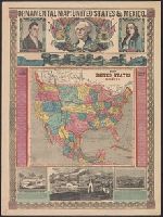
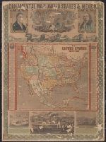
- Beinecke Rare Book and Manuscript Library > Map of the United States and Mexico / published by Johnson & Browning under the direction of Col. Carlos Butterfield.
- Published / Created:
- 1846
- Call Number:
- 75 1846C
- Container / Volume:
- BRBL_00399
- Image Count:
- 1
- Resource Type:
- Maps, Atlases & Globes
- Found in:
- Beinecke Rare Book and Manuscript Library > Map of the United States and Mexico Including Oregon, Texas and the Californias. By John Haven.
- Published / Created:
- 1846.]
- Call Number:
- 75 1846
- Container / Volume:
- BRBL_00399
- Image Count:
- 1
- Resource Type:
- Maps, Atlases & Globes
- Found in:
- Beinecke Rare Book and Manuscript Library > Map of the United States and Mexico Including Oregon, Texas and the Californias. By John Haven.
- Creator:
- Ensign, Bridgman & Fanning
- Published / Created:
- [1854]
- Call Number:
- 75 1854
- Container / Volume:
- BRBL_00401
- Image Count:
- 1
- Resource Type:
- Maps, Atlases & Globes
- Found in:
- Beinecke Rare Book and Manuscript Library > Map of the United States and Mexico.
- Creator:
- Ensign, Thayer & Co
- Published / Created:
- [1850]
- Call Number:
- 75 1850T
- Container / Volume:
- BRBL_00400
- Image Count:
- 1
- Resource Type:
- Maps, Atlases & Globes
- Found in:
- Beinecke Rare Book and Manuscript Library > Map of the United States and Mexico.
- Creator:
- Ensign, Bridgman & Fanning
- Published / Created:
- [185-?]
- Call Number:
- 71 185X
- Container / Volume:
- BRBL_00371
- Image Count:
- 1
- Resource Type:
- Maps, Atlases & Globes
- Found in:
- Beinecke Rare Book and Manuscript Library > Map of the United States and Mexico.
- Published / Created:
- 1872
- Call Number:
- 75 1872
- Container / Volume:
- BRBL_00405
- Image Count:
- 1
- Resource Type:
- Maps, Atlases & Globes
- Found in:
- Beinecke Rare Book and Manuscript Library > Map of the United States and Territories.
- Published / Created:
- [1844?]
- Call Number:
- 75 1844
- Container / Volume:
- BRBL_00399
- Image Count:
- 1
- Resource Type:
- Maps, Atlases & Globes
- Found in:
- Beinecke Rare Book and Manuscript Library > Map of the United States and Texas. Engraved by C. Copley, New York.
- Creator:
- Mitchell, S. Augustus (Samuel Augustus), 1792-1868
- Published / Created:
- 1860
- Call Number:
- 75 1860A
- Container / Volume:
- BRBL_00402
- Image Count:
- 1
- Resource Type:
- Maps, Atlases & Globes
- Found in:
- Beinecke Rare Book and Manuscript Library > Map of the United States and territories, together with Canada &c..
- Published / Created:
- 1831
- Call Number:
- 75 1831
- Container / Volume:
- BRBL_00398
- Image Count:
- 1
- Resource Type:
- Maps, Atlases & Globes
- Found in:
- Beinecke Rare Book and Manuscript Library > Map of the United States constructed from the latest authorities.
- Published / Created:
- 1833
- Call Number:
- 75 1833A
- Container / Volume:
- BRBL_00398
- Image Count:
- 1
- Resource Type:
- Maps, Atlases & Globes
- Found in:
- Beinecke Rare Book and Manuscript Library > Map of the United States constructed from the latest authorities.
- Creator:
- McGee, W. J., 1853-1912
- Published / Created:
- 1884
- Call Number:
- 75CA 1884
- Container / Volume:
- BRBL_00407A
- Image Count:
- 1
- Resource Type:
- Maps, Atlases & Globes
- Found in:
- Beinecke Rare Book and Manuscript Library > Map of the United States exhibiting the present status of knowledge relating to the areal distribution of geologic groups : (preliminary compilation) / compiled by W.J. McGee.
- Published / Created:
- [1840?]
- Call Number:
- 75gme 1840F
- Container / Volume:
- BRBL_00411
- Image Count:
- 1
- Resource Type:
- Maps, Atlases & Globes
- Found in:
- Beinecke Rare Book and Manuscript Library > Map of the United States of America to accompany Doggett's Railroad Guide.
- Creator:
- Reed and Barber
- Published / Created:
- 1850
- Call Number:
- 75 1850J
- Container / Volume:
- BRBL_00400
- Image Count:
- 1
- Resource Type:
- Maps, Atlases & Globes
- Found in:
- Beinecke Rare Book and Manuscript Library > Map of the United States of America with its territories & districts : Including also a part of upper & lower Canada and Mexico.
- Creator:
- Barber, Bissell B
- Published / Created:
- 1835
- Call Number:
- 75 1835A
- Container / Volume:
- BRBL_00398
- Image Count:
- 1
- Resource Type:
- Maps, Atlases & Globes
- Found in:
- Beinecke Rare Book and Manuscript Library > Map of the United States of America with its territories and districts : including also a part of upper & lower Canada and Mexico.
- Published / Created:
- .
- Call Number:
- 75H 1895
- Container / Volume:
- BRBL_00414A
- Image Count:
- 1
- Resource Type:
- Maps, Atlases & Globes
- Found in:
- Beinecke Rare Book and Manuscript Library > Map of the United States showing Military Posts and Principal Lines of Communication / Prepared by direction of the Secretary of War in the Office of the Chief of Engineers U.S.A.
- Published / Created:
- 1801
- Call Number:
- 755 1801
- Container / Volume:
- BRBL_00437
- Image Count:
- 1
- Resource Type:
- Maps, Atlases & Globes
- Found in:
- Beinecke Rare Book and Manuscript Library > Map of the United States, Canada, the Rriver St. Lawrence, the Lakes &e.
- Creator:
- Atwood, John M., b. ca. 1818
- Published / Created:
- 1849
- Call Number:
- 71 1849B
- Container / Volume:
- BRBL_00370
- Image Count:
- 1
- Resource Type:
- Maps, Atlases & Globes
- Found in:
- Beinecke Rare Book and Manuscript Library > Map of the United States, the British provinces, Mexico &c.
- Creator:
- Atwood, John M., b. ca. 1818
- Published / Created:
- 1849
- Call Number:
- 71 1849C
- Container / Volume:
- BRBL_00370
- Image Count:
- 1
- Resource Type:
- Maps, Atlases & Globes
- Found in:
- Beinecke Rare Book and Manuscript Library > Map of the United States, the British provinces, Mexico &c. / drawn & engraved by J.M. Atwood.