Search
You Searched For
Search Results
- Published / Created:
- 1796
- Call Number:
- 75 1796A
- Container / Volume:
- BRBL_00396
- Image Count:
- 1
- Resource Type:
- Maps, Atlases & Globes
- Found in:
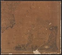
- Beinecke Rare Book and Manuscript Library > A Geographical View of all the Post Towns in the United States of America and their distances from each other according to the establishment of the Postmaster General, 1796. By Samuel A. Puddock, Accomptant, Boston. B. Callender, Sculp., Boston.
- Creator:
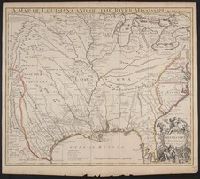
- Senex, John, d. 1740
- Published / Created:
- 1721]
- Call Number:
- 755 1715A
- Container / Volume:
- BRBL_00425
- Image Count:
- 1
- Resource Type:
- Maps, Atlases & Globes
- Found in:
- Beinecke Rare Book and Manuscript Library > A map of Louisiana and of the river Mississipi [i.e. Mississippi] : this map of the Mississipi [i.e. Mississippi] is most humbly inscribed to William Law of Lanreston, esq. / by Iohn Senex.
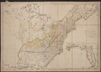
- Creator:
- Bowen, Emanuel, d. 1767
- Published / Created:
- 1754
- Call Number:
- 75 1720
- Container / Volume:
- BRBL_00689
- Image Count:
- 1
- Resource Type:
- Maps, Atlases & Globes
- Found in:
- Beinecke Rare Book and Manuscript Library > A map of the British American plantations [cartographic material] : extending from Boston in New England to Georgia, including all the back settlements in the respective provinces, as far as the Mississippi / by Eman. Bowen Geogr. to His Majesty ; Tho. Bo
- Published / Created:
- 1795
- Call Number:
- 75 1795
- Container / Volume:
- BRBL_00396
- Image Count:
- 1
- Resource Type:
- Maps, Atlases & Globes
- Found in:
- Beinecke Rare Book and Manuscript Library > A map of the United States; Compiled chiefly from the State maps, and other authentic information, by Saml. Lewis. W. Harrison Jun. Sculp.
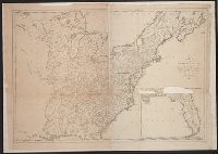
- Creator:
- Buell, Abel, 1742-1822
- Published / Created:
- 1784]
- Call Number:
- 755 1783W
- Container / Volume:
- BRBL_00434
- Image Count:
- 4
- Resource Type:
- Maps, Atlases & Globes
- Found in:
- Beinecke Rare Book and Manuscript Library > A new and correct map of the United States of North America : layd down from the latest observations and best authorities, agreeable to the Peace of 1783 / humbly inscribed to His Excellency the Governor and Company of the State of Connecticut by ... Abel
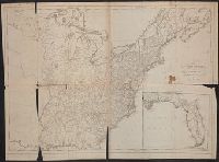
- Published / Created:
- [1754]
- Call Number:
- 755 1754
- Container / Volume:
- BRBL_00728
- Image Count:
- 1
- Resource Type:
- Maps, Atlases & Globes
- Found in:
- Beinecke Rare Book and Manuscript Library > An accurate map of the English colonies in North America, bordering on the river Ohio.