Search
You Searched For
Search Results
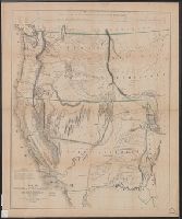
- Creator:
- Warren, Gouverneur Kemble, 1830-1882
- Published / Created:
- 1856]
- Call Number:
- 80 1855B
- Container / Volume:
- BRBL_00534
- Image Count:
- 1
- Resource Type:
- Maps, Atlases & Globes
- Found in:
- Beinecke Rare Book and Manuscript Library > Section of map compiled in P.R.R. Office with additions designed to illustrate Lt. Warrens report of military reconnaissances in the Dacota Country 1855 / compiled by Lt. [G.K.] Warren, T.E. ; drawn by E. Fréyhold.
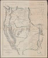
- Creator:
- Frémont, John Charles, 1813-1890
- Published / Created:
- 1848
- Call Number:
- 80 1848A
- Container / Volume:
- BRBL_00533
- Image Count:
- 1
- Resource Type:
- Maps, Atlases & Globes
- Found in:
- Beinecke Rare Book and Manuscript Library > Map of Oregon and upper California from the surveys of John Charles Frémont and other authorities / drawn by Charles Preuss under the order of the Senate of the United States ; lithy. by E. Weber & Co., Balto.
- Creator:
- Simpson, J. H. (James Hervey), 1813-1883
- Published / Created:
- 1850?]
- Call Number:
- 80 1849B
- Container / Volume:
- BRBL_00533
- Image Count:
- 1
- Resource Type:
- Maps, Atlases & Globes
- Found in:
- Beinecke Rare Book and Manuscript Library > Map of route pursued by U.S. troops from Fort Smith, Arkansas, to Santa Fé, New Mexico, via south side of Canadian River in the year 1849 whilst serving as an escort to a party of California emigrants : escort commanded ... by Capt. R.B. Marcy ... Explor
- Published / Created:
- 1855-6]
- Call Number:
- 80 1855C
- Container / Volume:
- BRBL_00534
- Image Count:
- 1
- Resource Type:
- Maps, Atlases & Globes
- Found in:
- Beinecke Rare Book and Manuscript Library > Map showing the different routes travelled over by the detachments of the Overland Command in the spring of 1855 : from Salt Lake City, Utah, to the Bay of San Francisco.
- Creator:
- Frémont, John Charles, 1813-1890
- Published / Created:
- 1848
- Call Number:
- 80 1848A
- Container / Volume:
- BRBL_00533
- Image Count:
- 1
- Resource Type:
- Maps, Atlases & Globes
- Found in:
- Beinecke Rare Book and Manuscript Library > Map of Oregon and upper California from the surveys of John Charles Frémont and other authorities / drawn by Charles Preuss under the order of the Senate of the United States ; lithy. by E. Weber & Co., Balto.
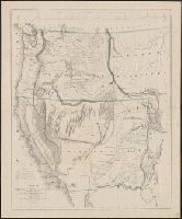
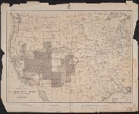
- Creator:
- Geographical Surveys West of the 100th Meridian (U.S.)
- Published / Created:
- 1877
- Call Number:
- 80b 1877
- Container / Volume:
- BRBL_00537
- Image Count:
- 1
- Resource Type:
- Maps, Atlases & Globes
- Found in:
- Beinecke Rare Book and Manuscript Library > Progress map of the U.S. Geographical Surveys west of the 100th meridian. 1877 : to accompany the annual report of 1st lieut. George M. Wheeler / 1st lieut. Geo. M. Wheeler, Corps of Engineers, U.S. Army, in charge ; under the direction of Brig. Gen. A.A.