Search
You Searched For
Search Results
- Creator:
- Frémont, John Charles, 1813-1890
- Published / Created:
- 1848
- Call Number:
- 80 1848A
- Container / Volume:
- BRBL_00533
- Image Count:
- 1
- Resource Type:
- Maps, Atlases & Globes
- Found in:
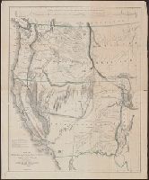
- Beinecke Rare Book and Manuscript Library > Map of Oregon and upper California from the surveys of John Charles Frémont and other authorities / drawn by Charles Preuss under the order of the Senate of the United States ; lithy. by E. Weber & Co., Balto.
- Creator:
- Frémont, John Charles, 1813-1890
- Published / Created:
- 1848
- Call Number:
- 80 1848A
- Container / Volume:
- BRBL_00533
- Image Count:
- 1
- Resource Type:
- Maps, Atlases & Globes
- Found in:
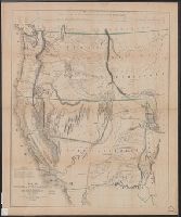
- Beinecke Rare Book and Manuscript Library > Map of Oregon and upper California from the surveys of John Charles Frémont and other authorities / drawn by Charles Preuss under the order of the Senate of the United States ; lithy. by E. Weber & Co., Balto.
- Creator:
- Frémont, John Charles, 1813-1890
- Published / Created:
- 1848
- Call Number:
- 80 1848A
- Container / Volume:
- BRBL_00533
- Image Count:
- 1
- Resource Type:
- Maps, Atlases & Globes
- Found in:
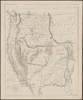
- Beinecke Rare Book and Manuscript Library > Map of Oregon and upper California from the surveys of John Charles Frémont and other authorities / drawn by Charles Preuss under the order of the Senate of the United States ; lithy. by E. Weber & Co., Balto.
- Creator:
- Preuss, Charles, 1803-1854
- Published / Created:
- 1846]
- Call Number:
- 80 1846A
- Container / Volume:
- BRBL_00533
- Image Count:
- 7
- Resource Type:
- Maps, Atlases & Globes
- Found in:
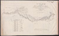
- Beinecke Rare Book and Manuscript Library > Topographical map of the road from Missouri to Oregon : commencing at the mouth of the Kansas in the Missouri River and ending at the mouth of the Wallah Wallah in the Columbia / from the field notes and journal of Capt. J.C. Frémont, and from sketches a