Search
You Searched For
Search Results
- Creator:
- Ensigns & Thayer
- Published / Created:
- [1849?]
- Call Number:
- 844 1849B
- Container / Volume:
- BRBL_00601
- Image Count:
- 1
- Resource Type:
- Maps, Atlases & Globes
- Found in:
- Beinecke Rare Book and Manuscript Library > Map of the gold regions of California : showing the routes via Chagres and Panama, Cape Horn, &c.
- Creator:
- Bowles, Samuel, 1826-1878
- Published / Created:
- [1865]
- Call Number:
- 80bh 1865
- Container / Volume:
- BRBL_00537
- Image Count:
- 1
- Resource Type:
- Maps, Atlases & Globes
- Found in:
- Beinecke Rare Book and Manuscript Library > Map of the territories and Pacific states to accompany "across the continent" / by Samuel Bowles.
- Creator:
- Warren, Gouverneur Kemble, 1830-1882
- Published / Created:
- 1858?]
- Call Number:
- 80 1857E
- Container / Volume:
- BRBL_00534
- Image Count:
- 2
- Resource Type:
- Maps, Atlases & Globes
- Found in:
- Beinecke Rare Book and Manuscript Library > Map of the territory of the United States from the Mississippi to the Pacific Ocean : ordered by Jeff'n Davis, Secretary of War to accompany the reports of the explorations for a railroad route / compiled from authorized explorations and other reliable da
- Creator:
- Freyhold, Edward
- Published / Created:
- 1879
- Call Number:
- 80 1879
- Container / Volume:
- BRBL_00536
- Image Count:
- 5
- Resource Type:
- Maps, Atlases & Globes
- Found in:
- Beinecke Rare Book and Manuscript Library > Map of the territory of the United States, west of the Mississippi River / prepared by authority of the Hon. the Secretary of War, in the office of the Chief of Engineers under the direction of Brig. Gen. A.A. Humphreys, Chief of Engrs. Bvt. Major General
- Creator:
- Freyhold, Edward
- Published / Created:
- 1879
- Call Number:
- 80 1879
- Container / Volume:
- BRBL_00536
- Image Count:
- 2
- Resource Type:
- Maps, Atlases & Globes
- Found in:
- Beinecke Rare Book and Manuscript Library > Map of the territory of the United States, west of the Mississippi River / prepared by authority of the Hon. the Secretary of War, in the office of the Chief of Engineers under the direction of Brig. Gen. A.A. Humphreys, Chief of Engrs. Bvt. Major General
- Published / Created:
- [1912?]
- Call Number:
- 80gme 1912
- Container / Volume:
- BRBL_00540
- Image Count:
- 1
- Resource Type:
- Maps, Atlases & Globes
- Found in:
- Beinecke Rare Book and Manuscript Library > Map showing Northern Pacific Railway System, Chicago, Burlington & Quincy R.R. system, Spokane, Portland & Seattle Railway and its subsidiary lines ... Spokane & Inland Empire Railroad, [and] Colorado & Southern Railway System.
- Published / Created:
- ca. 1783
- Call Number:
- GA405 +W44 (LC)
- Collection Title:
- Mapping the transmississippi West, 1540-1861
- Image Count:
- 1
- Found in:
- Beinecke Rare Book and Manuscript Library > Mapa de las provincias internas de la America septentrional [facsimile]
- Creator:
- Morris, C. A. F
- Published / Created:
- [1864]
- Call Number:
- 80 1864A
- Container / Volume:
- BRBL_00535
- Image Count:
- 1
- Resource Type:
- Maps, Atlases & Globes
- Found in:
- Beinecke Rare Book and Manuscript Library > Minnesota route, the shortest and best to the Idaho gold mines / compiled by C.A.F. Morris.
- Creator:
- Carey, Mathew, 1760-1839
- Published / Created:
- 1814]
- Call Number:
- 80 1814D
- Container / Volume:
- BRBL_00532
- Image Count:
- 1
- Resource Type:
- Maps, Atlases & Globes
- Found in:
- Beinecke Rare Book and Manuscript Library > Missouri Territory formerly Louisiana / Lewis, del. ; Bower, sc.
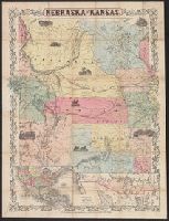
- Creator:
- J.H. Colton & Co
- Published / Created:
- [1855?]
- Call Number:
- 824 1855A
- Container / Volume:
- BRBL_00570
- Image Count:
- 1
- Resource Type:
- Maps, Atlases & Globes
- Found in:
- Beinecke Rare Book and Manuscript Library > Nebraska and Kansas.