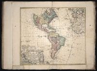
Map of all the world in two hemispheres in which are exactly described all the parts of the earth and seas
Description:
Dedicated To the most serene and most sacred majesty of Charles II ..., Described by Sanson ; corrected and amended by William Berry., Includes coat of arms and decorative cartouche containing dedication., No. 1 of 69 maps bound together in composite atlas., Prime meridian: Ferro., Relief shown pictorially., Scale [ca. 1:60 000 000]., and Shows California as an island.
Publisher:
Sold by William Berry at ye sign of the globe between Charing-Cross and White-Hall
Subject (Geographic):
Eastern Hemisphere --Maps --Early works to 1800 and Western Hemisphere --Maps --Early works to 1800
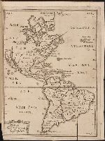
Compiled from Mr. D'Anville's maps of that continent, with the addition of the Spanish discoveries in 1775 to the north of California & corrected in the several parts belonging to Great Britain from the original materials of Governor Pownall, M.P., From Thomas Kitchin's a general atlas describing the whole universe. [1793]., Includes inset The supplement to North America containing the countries adjoining to Baffins & Hudsons Bays and tables showing European possessions., No. 39 of 43 maps bound together in composite atlas., Prime meridian: Ferro., Relief shown pictorially., and Scale [ca. 1:11,500,000].
Publisher:
Printed for Robt. Sayer, map, chart & printseller
Subject (Geographic):
United States --Maps --Early works to 1800 and Western Hemisphere --Maps --Early works to 1800
Kort beskrifning om provincien Nya Swerige uti America : som nu foertjden af the Engelske kallas
Image Count:
1
Description:
Preceding p. 1. and Teaching resource: Professor John Mack Faragher, History 141: The American West.
Subject (Geographic):
Canada --Discovery and exploration, South America --Discovery and exploration, United States --Discovery and exploration, and Western Hemisphere --Maps --Early works to 1800
Collection Created:
Stockholm : Tryckt uti Kongl. boktr. hos S. Wankijfs ankia, med egen bekostnad, af J. H. Werner, 1702
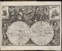
Jovrnal ou Description dv merveillevx voyage de Gvillavme Schovten, hollandois natif de Hoorn
Image Count:
1
Abstract:
Depicts notable explorers of the time as well as two ships, the Victoria and the Eendracht.
Description:
Bound in preceding first page of text., In ink on recto: Olivier van Nort [sic]., and Scale not given.
Subject (Geographic):
Eastern Hemisphere --Maps --Early works to 1800 and Western Hemisphere --Maps --Early works to 1800
Subject (Name):
Cavendish, Thomas, 1560-1592, Drake, Francis, Sir, 1540?-1596, Magalhaes, Fernao de, d. 1521, Noort, Olivier van, 1558 or 9-1627, Schouten, Willem Corneliszoon, d. 1625, and Spilbergen, Joris van, 1568?-1620
Subject (Topic):
Voyages around the world --To 1700
Collection Created:
A Amstredam : Chez Harman Ianson, marchand libraire, demeurant en la VVarmoes-straet, a le Sereine, 1619