Search
You Searched For
Search Results
- Published / Created:
- [1932?], c1931.
- Call Number:
- 833gmb 1932
- Container / Volume:
- BRBL_00586
- Image Count:
- 2
- Resource Type:
- Maps, Atlases & Globes
- Found in:
- Beinecke Rare Book and Manuscript Library > 1932 highway map of the state of Wyoming.
- Creator:
- Wyoming. State Highway Dept
- Published / Created:
- [1933]
- Call Number:
- 833gmb 1933
- Container / Volume:
- BRBL_00586
- Image Count:
- 2
- Resource Type:
- Maps, Atlases & Globes
- Found in:
- Beinecke Rare Book and Manuscript Library > 1933 highway map of the state of Wyoming / Wyoming State Highway Department.
- Creator:
- Asher & Adams
- Published / Created:
- [1874?]
- Call Number:
- 833 1874
- Container / Volume:
- BRBL_00584
- Image Count:
- 1
- Resource Type:
- Maps, Atlases & Globes
- Found in:
- Beinecke Rare Book and Manuscript Library > Asher & Adams' Wyoming.
- Creator:
- Clason Map Co
- Published / Created:
- [1919].
- Call Number:
- 833 1919
- Container / Volume:
- BRBL_00584
- Image Count:
- 2
- Resource Type:
- Maps, Atlases & Globes
- Found in:
- Beinecke Rare Book and Manuscript Library > Clason's guide map of Wyoming / compliments of Douglas National Bank, Douglas, Wyoming.
- Creator:
- H.M. Gousha Company
- Published / Created:
- [1927]
- Call Number:
- 833gmb 1927
- Container / Volume:
- BRBL_00586
- Image Count:
- 2
- Resource Type:
- Maps, Atlases & Globes
- Found in:
- Beinecke Rare Book and Manuscript Library > Continental Oil Co. official road map, Wyoming.
- Creator:
- Bond, Frank, 1856-1940
- Published / Created:
- [1884]
- Call Number:
- 833 1884
- Container / Volume:
- BRBL_00584
- Image Count:
- 1
- Resource Type:
- Maps, Atlases & Globes
- Found in:
- Beinecke Rare Book and Manuscript Library > Holt's new map of Wyoming : compiled by permission from official records in U.S. Land Office / Frank & Fred Bond, draftsmen.
- Creator:
- Bond, Frank, 1856-1940
- Published / Created:
- 1886
- Call Number:
- 833 1886
- Container / Volume:
- BRBL_00584
- Image Count:
- 1
- Resource Type:
- Maps, Atlases & Globes
- Found in:
- Beinecke Rare Book and Manuscript Library > Holt's new map of Wyoming : compiled by permission from official records in U.S. Land Office / Frank & Fred. Bond, draftsmen.
- Creator:
- Rand McNally and Company
- Published / Created:
- [1960]
- Call Number:
- 832 1960
- Container / Volume:
- BRBL_00582
- Image Count:
- 2
- Resource Type:
- Maps, Atlases & Globes
- Found in:
- Beinecke Rare Book and Manuscript Library > Idaho, Montana, Wyoming / [prepared for] Sinclair.
- Creator:
- Clason Map Co
- Published / Created:
- c1917.
- Call Number:
- 833 1917A
- Container / Volume:
- BRBL_00584
- Image Count:
- 1
- Resource Type:
- Maps, Atlases & Globes
- Found in:
- Beinecke Rare Book and Manuscript Library > Map of the Wyoming oil fields.
- Creator:
- United States. General Land Office
- Published / Created:
- 1900
- Call Number:
- 833 1900
- Container / Volume:
- BRBL_00584
- Image Count:
- 1
- Resource Type:
- Maps, Atlases & Globes
- Found in:
- Beinecke Rare Book and Manuscript Library > Map of the state of Wyoming / compiled from the official records of the General Office and other sources, under the direction of Harry King, C.E., Chief of Drafting Division G.L.O. ; compiled, drawn, and lettered by I.P. Berthrong.
- Creator:
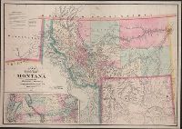
- De Lacy, W. W. (Walter Washington), 1819-1892
- Published / Created:
- 1870
- Call Number:
- 831 1870
- Container / Volume:
- BRBL_00579
- Image Count:
- 1
- Resource Type:
- Maps, Atlases & Globes
- Found in:
- Beinecke Rare Book and Manuscript Library > Map of the territory of Montana with portions of the adjoining territories / compiled and drawn by W.W. De Lacy of the Surveyor General's Office, Helena, M.T. ; engraved, printed and published by G.W. & C.B. Colton & Co.
- Creator:
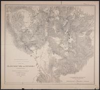
- Geological Survey of the Territories (U.S.)
- Published / Created:
- 1871
- Call Number:
- 80 1871
- Container / Volume:
- BRBL_00535
- Image Count:
- 1
- Resource Type:
- Maps, Atlases & Globes
- Found in:
- Beinecke Rare Book and Manuscript Library > Parts of Idaho, Montana and Wyoming territories / from surveys made under the direction of F.V. Hayden and other authorities ; compiled and drawn by E. Hergesheimer.
- Creator:
- Geological and Geographical Survey of the Territories (U.S.)
- Published / Created:
- [1878]
- Call Number:
- 833 1878
- Container / Volume:
- BRBL_00584
- Image Count:
- 1
- Resource Type:
- Maps, Atlases & Globes
- Found in:
- Beinecke Rare Book and Manuscript Library > Parts of western Wyoming and southeastern Idaho / U.S. Geological and Geographical Survey of the Territories ; F.V. Hayden, U.S. geologist in charge ; G.R. Bechler and Fred A. Clark, topographical assistants.
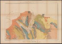
- Creator:
- Geological and Geographical Survey of the Territories (U.S.)
- Published / Created:
- [1878]
- Call Number:
- 833ca 1878
- Container / Volume:
- BRBL_00585
- Image Count:
- 1
- Resource Type:
- Maps, Atlases & Globes
- Found in:
- Beinecke Rare Book and Manuscript Library > Parts of western Wyoming and southeastern Idaho / U.S. Geological and Geographical Survey of the Territories ; F.V. Hayden, U.S. geologist in charge ; O. St. John, geological assistant ; G.R. Bechler and Fred A. Clark, topographical assistants.
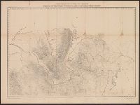
- Creator:
- Geological and Geographical Survey of the Territories (U.S.)
- Published / Created:
- [1877]
- Call Number:
- 833ca 1878AB
- Container / Volume:
- BRBL_00585
- Image Count:
- 1
- Resource Type:
- Maps, Atlases & Globes
- Found in:
- Beinecke Rare Book and Manuscript Library > Parts of western Wyoming, southeastern Idaho and northeastern Utah [cartographic material] / F.V. Hayden, U.S. geologist in charge ; Harry Gannett, M.E., topographical assistant ; Julius Bien, lith., New York.
- Creator:
- Rand McNally and Company
- Published / Created:
- [1949?]
- Call Number:
- 832gmb 1949
- Container / Volume:
- BRBL_00583
- Image Count:
- 2
- Resource Type:
- Maps, Atlases & Globes
- Found in:
- Beinecke Rare Book and Manuscript Library > Rand McNally road map, Idaho, Montana - Wyoming / issued by Randall Motor Club, Inc. affiliated with E. Broox Randall & Sons, Inc.
- Creator:
- United States. General Land Office
- Published / Created:
- 1876
- Call Number:
- 833 1876
- Container / Volume:
- BRBL_00584
- Image Count:
- 1
- Resource Type:
- Maps, Atlases & Globes
- Found in:
- Beinecke Rare Book and Manuscript Library > Territory of Wyoming / compiled from the official records of the General Land Office and other sources by C. Roeser, Principal Draughtsman, G.L.O.
- Creator:
- United States. General Land Office
- Call Number:
- 833 1879
- Container / Volume:
- BRBL_00584
- Image Count:
- 1
- Resource Type:
- Maps, Atlases & Globes
- Found in:
- Beinecke Rare Book and Manuscript Library > Territory of Wyoming : 1879 / compiled from the official records of the General Land Office and other sources by C. Roeser, Principal Draughtsman, G.L.O.
- Creator:
- United States. General Land Office
- Published / Created:
- 1888
- Call Number:
- 833 1888
- Container / Volume:
- BRBL_00584
- Image Count:
- 1
- Resource Type:
- Maps, Atlases & Globes
- Found in:
- Beinecke Rare Book and Manuscript Library > Territory of Wyoming : 1888 / compiled from the official records of the General Land Office and other sources under supervision of Geo. U. Mayo., compiled and drawn by A.F. Dinsmore, 1887.
- Creator:
- Rand McNally and Company
- Published / Created:
- [1942]
- Call Number:
- 833gmb 1942
- Container / Volume:
- BRBL_00586
- Image Count:
- 2
- Resource Type:
- Maps, Atlases & Globes
- Found in:
- Beinecke Rare Book and Manuscript Library > Texaco touring map of Wyoming.
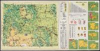
- Creator:
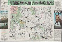
- Wyoming. State Highway Commission
- Published / Created:
- 1952
- Call Number:
- 833gmb 1952
- Container / Volume:
- BRBL_00586
- Image Count:
- 2
- Resource Type:
- Maps, Atlases & Globes
- Found in:
- Beinecke Rare Book and Manuscript Library > Wyoming highway map / by Wyoming State Highway Commission ; prepared by Rand McNally & Co.
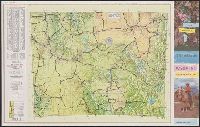
- Creator:
- Wyoming. State Highway Dept
- Published / Created:
- [1939]
- Call Number:
- 833gmb 1939
- Container / Volume:
- BRBL_00586
- Image Count:
- 2
- Resource Type:
- Maps, Atlases & Globes
- Found in:
- Beinecke Rare Book and Manuscript Library > Wyoming highway map, 1939.
- Creator:
- Rand McNally and Company
- Published / Created:
- 1955]
- Call Number:
- 833gmb 1955
- Container / Volume:
- BRBL_00586
- Image Count:
- 2
- Resource Type:
- Maps, Atlases & Globes
- Found in:
- Beinecke Rare Book and Manuscript Library > Wyoming highway map, 1955 / Wyoming State Highway Commission ; prepared by Rand McNally & Co.
- Creator:
- A. B. Hirschfeld Press
- Published / Created:
- 1975
- Call Number:
- 833gmb 1976
- Container / Volume:
- BRBL_00586
- Image Count:
- 2
- Resource Type:
- Maps, Atlases & Globes
- Found in:
- Beinecke Rare Book and Manuscript Library > Wyoming, 1976 / prepared by The A.B. Hirschfeld Press.
- Creator:
- A. B. Hirschfeld Press
- Published / Created:
- 1977
- Call Number:
- 833gmb 1977
- Container / Volume:
- BRBL_00586
- Image Count:
- 2
- Resource Type:
- Maps, Atlases & Globes
- Found in:
- Beinecke Rare Book and Manuscript Library > Wyoming, 1977, official highway map / prepared by The A.B. Hirschfeld Press.