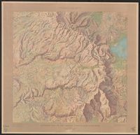
Covers area from Mariposa to Big Oak Flat and east to Mono Lake., Relief shown by hachures., and Unlike earlier ed., area east of Bridgeport is hachured, and a number of names have been changed including "Wagon road between Coulterville and Gentry's" changed from "Coulterville and Yosemite trail."
Publisher:
The Survey,
Subject (Geographic):
Sierra Nevada (Calif. and Nev.)--Maps and Yosemite National Park (Calif.)--Maps
Subject (Name):
Gardner, J. T, Hoffmann, C. F. (Charles Frederick), 1838-1913, and Whitney, J. D. (Josiah Dwight), 1819-1896
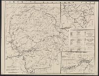
"Form M-111" and "156" on panel., Map of "Yosemite Valley" (scale [ca. 1:50,000]), distance tables, and text on verso., and Relief shown by spot heights.
Publisher:
California State Automobile Association,
Subject (Geographic):
San Joaquin Valley (Calif.)--Maps and Yosemite National Park (Calif.)--Maps
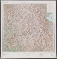
"Compiled in 1963 from 1:62,500-scale maps dated 1947, 1953, 1956, and 1958.", "N3728--W11900/45X60.", Includes location map and USGS index map., and Relief shown by shading, contours, and spot heights.
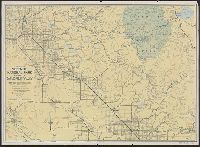
In lower right margin: N.P.-YOS. 7002., Includes distance chart, text, and maps of "Routes to Yosemite National Park," and "Roads in Yosemite Valley.", On verso: U.S. Government Printing Office, 1943., Relief shown by hachures and spot heights., and Text and ill.