Search
You Searched For
Search Results
- Creator:
- Teleki, Pál, gróf, 1879-1941
- Published / Created:
- [1910?]
- Call Number:
- 43ed 1910
- Container / Volume:
- BRBL_00251
- Image Count:
- 1
- Resource Type:
- Maps, Atlases & Globes
- Found in:
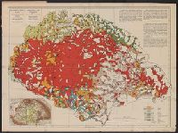
- Beinecke Rare Book and Manuscript Library > Magyarország néprajzi térképe a népsűrűség alapján = / szerkesztette Gróf Teleki Pál = Ethnographical map of Hungary based on the density of population / by Count Paul Teleki.
- Creator:
- Županić, Niko
- Published / Created:
- 1915
- Call Number:
- 11hcf 1919E-27
- Container / Volume:
- BRBL_00010ZA
- Image Count:
- 1
- Resource Type:
- Maps, Atlases & Globes
- Found in:
- Beinecke Rare Book and Manuscript Library > Jugoslovenska zemlja = The Jugoslav territory = Le territoire Iougoslave : Map of Jugoslav territory / by Dr. Niko Županić ; Issued for the Jugoslav community in London.
- Published / Created:
- 191-.
- Call Number:
- 11hcf 1919E-31
- Container / Volume:
- BRBL_00010ZA
- Image Count:
- 1
- Resource Type:
- Maps, Atlases & Globes
- Found in:
- Beinecke Rare Book and Manuscript Library > [Spalato and envrions.]
- Creator:
- Great Britain. General Staff. Geographical Section
- Published / Created:
- 1919
- Call Number:
- 11hcf 1919-4
- Container / Volume:
- BRBL_00010L
- Image Count:
- 1
- Resource Type:
- Maps, Atlases & Globes
- Found in:
- Beinecke Rare Book and Manuscript Library > Map of the Dragoman Pass, GSGS 2922.
- Published / Created:
- 191-.
- Call Number:
- 11hcf 1919A-13
- Container / Volume:
- BRBL_00010M
- Image Count:
- 1
- Resource Type:
- Maps, Atlases & Globes
- Found in:
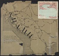
- Beinecke Rare Book and Manuscript Library > [Map used discussions of in Rumanian-Yugoslav Committee, regarding Rumanian-Hungarian boundary, March 1919.]
- Creator:
- Teleki, Pál, gróf, 1879-1941
- Published / Created:
- 1919
- Call Number:
- 11hcf 1919-51
- Container / Volume:
- BRBL_00010L
- Image Count:
- 1
- Resource Type:
- Maps, Atlases & Globes
- Found in:
- Beinecke Rare Book and Manuscript Library > Magyarország néprajzi térképe a népsürüség alapján = / szerkesztette Grof Teleki Pál = Ethnographical map of Hungary based on the density of population / by Count Paul Teleki = Carte ethnographique de la Hongrie construite en la accordance avec
- Published / Created:
- 191-.
- Call Number:
- 11hcf 1919A-12
- Container / Volume:
- BRBL_00010M
- Image Count:
- 1
- Resource Type:
- Maps, Atlases & Globes
- Found in:
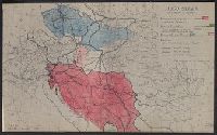
- Beinecke Rare Book and Manuscript Library > Map used in Rumanian-Jugoslav Committee discussions of Banat and Transylvanian proposed frontiers. Feb-March 1919.
- Published / Created:
- 1918
- Call Number:
- 11hcf 1919A-3
- Container / Volume:
- BRBL_00010N
- Image Count:
- 1
- Resource Type:
- Maps, Atlases & Globes
- Found in:
- Beinecke Rare Book and Manuscript Library > [Jugo-Slavia (According to Županić)] / map prepared by R.J. Kerner, 1918.
- Published / Created:
- 191-?]
- Call Number:
- 11hcf 1919D-17
- Container / Volume:
- BRBL_00010W
- Image Count:
- 1
- Resource Type:
- Maps, Atlases & Globes
- Found in:
- Beinecke Rare Book and Manuscript Library > [Fiume].