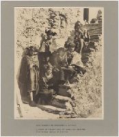
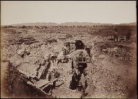
Photograph album with photographs taken by an unidentified photographer of mining town Ajo, Arizona, 1917-1918. Depicted are copper mining operations at the New Cornelia mine, as well as identified men and women. 9 photographs are attributed to Hadsell Foto; "Hadsell" himself appears in multiple photographs
Description:
Captions in English., Title from front cover., and Place of creation and date from front cover.
Subject (Geographic):
Arizona, Arizona., and Ajo (Ariz.)
Subject (Name):
Hadsell Foto.
Subject (Topic):
Copper miners, Copper mines and mining, and Mines and mineral resources
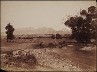
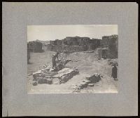
Photographs by C. C. Pierce, G. Wharton James, and Frank H. Nowell of Navajo, Hopi, Pima, Havasupai, Flathead and Seminole Indians. Included are views of cliff dwellings, villages, and kivas and photographs of weaving, pottery making and other activities in Shipolovi, Shongopovi, and Mishongnovi pueblos, and views of the Grand Canyon of Arizona. In New Mexico, views include an old church and the feast of St. Stephen at Acoma, and the village of Laguna and In Colorado, there is one photograph of the Cliff Palace in Marcus Canyon. In Montana, the photographs consist entirely of portraits of Flathead Indian families, chiefs, and warriors. There is one photograph of Alaskan basketry, and a single portrait of the Seminole chief Billy Bowlegs in Florida
Description:
Photographs are mounted on boards, and are accompanied by typescript captions. Six photographs are accompanied by maps of Navajo, Hopi, Havasupai, Flathead and Seminole Indian Reserves. A single print has extensive hand coloring.
Subject (Geographic):
Arizona, Grand Canyon (Ariz.), Acoma (N.M.), Laguna (N.M.), Walpi (Ariz.), and Oraibi (Ariz.)
Subject (Name):
Hotte, Arthur.
Subject (Topic):
Indians of North America, Navajo Indians, Salish Indians, Pima Indians, Seminole Indians, Hopi Indians, Pueblo Indians, Rites and ceremonies, Kivas, Pueblos, Snake dance, Indian baskets, and Cliff-dwellings
Photograph album created by Sumner Matteson from a selection of his photographs of the Southwest, Montana, and Colorado. The photographs, which are captioned in a typed list that accompanies the album, date from 1899 to 1902, and depict a variety of places and events. The majority of the photographs are of the Hopi Indians, their Snake, Antelope, and Flute ceremonies, kiva interiors, as well as weaving, grinding corn, courting, working in fields, making pottery, and marketing at the Moenkopi, Mishongnovi, Shipolovi and Shongopovi Pueblos. There are also photographs of cliff-dwellings at Mesa Verde and Mancos Canyon, Colorado; Canyon de Chelly, Arizona; Pueblo Indians at Isleta and Acoma, New Mexico; Navajo and Ute Indians in New Mexico and Colorado; Penitentes in Abiquiu, New Mexico; and views of wagon trains, Indian encampments, mines, and sheepherding in Montana
Description:
Sumner Matteson, a bicycle salesman in Denver who became a photographer, traveled around the West between 1899 and 1903, photographing the Mesa Verde and Pueblo Bonito cliff-dwellings, Navajo Indians, Penitentes in New Mexico, Hopi Snake and Flute ceremonies in Arizona, the Pueblo villages of Acoma and Isleta, Montana wagon trains, and cattle and sheep roundups. He sold his own photographs, wrote articles and provided illustrations for popular magazines, and provided photographs for several books on Southwestern Indians written by others., Accompanied by a contemporary typescript containing captions and often explanatory background for almost all of the photographs in the album. Typescript titled "Index to the Frank Klepetko Album. Photos and Data by Sumner W. Matteson" and signed "Sumner W. Matteson, D.A.C. [Denver Athletic Club] Denver, Colo. Jan. 1903.", Individual photographs are 12 x 17 cm. and smaller., 157 of the photographs are platinum prints., Album and copy prints in 2 boxes., and Copy prints available for every page except the first.
Subject (Geographic):
Southwest, New, Montana, New Mexico, Arizona, Abiquiu (N.M.), Acoma (N.M.), Canyon de Chelly National Monument (Ariz.), Colorado, Isleta (N.M.), Mancos Site (Colo.), Mesa Verde National Park (Colo.), Moenkopi Pueblo (Ariz.), and West (U.S.)
Subject (Name):
Klepetko, Frank., Matteson, Sumner W., 1867-1920., and Hermanos Penitentes
Subject (Topic):
Hopi Indians, Rites and ceremonies, Indians of North America, Cliff-dwellings, Kivas, Navajo Indians, Pueblo Indians, Snake dance, Mines and mineral resources, Sheep ranches, Wool industry, and Religious life and customs
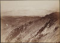
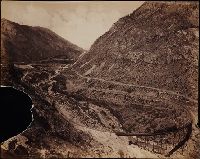
Photographs created from mammoth plate negatives primarily by photographers Carleton E. Watkins and William Henry Jackson of various locations in the American West, primarily in the states of California, Colorado, and Oregon, as well as Arizona, Montana, Utah, Washington, and Wyoming Territories, ca. 1874-1898, Photographs by Watkins consist of images created in the states of California and Oregon, and in Arizona, Montana, Utah, Washington, and Wyoming Territories, ca. 1874-1890, An image created by Watkins of Tombstone, Arizona Territory shows the Old South Shaft Ore Quarry of the Tough Nut Mine with a view of the town, the Dragoon Mountains, and the Cochise Stronghold in the distance, 1880, Images created by Watkins in California consist primarily of locations in Yosemite National Park, including Half Dome, Sentinel Rock, Tutocanula Pass (consisting of El Capitan and Cathedral Rocks cliff), and views of the Yosemite Valley from the Mariposa Trail and Eagle Point, 1878-1881. Other images from California include two different views from the top of Round Top Mountain, with one of the images showing a view of the Blue Lakes and the other the Mokelumne River, 1879; views in the vicinity of San Gabriel showing residences and wine houses of the Lake Vineyard, near the Sierra Madre Mountains and a date palm tree on the grounds of the Mission San Gabriel Arcangel, ca. 1874-1880; a view of the Carmel Valley from the Mission Road, Monterey; and a view of a waterfall, probably the Palisades Falls on the North Fork American River at Soda Springs, ca. 1874-1880, Images created by Watkins in Marysville, Montana Territory, consist of a view of the town, three interior views of a mill, and a view of the Drumlummon Mine and the Maskelyne Tunnel, 1884-1885 or 1890, Images created by Watkins along the Columbia River, Oregon, consist of views of rock bluffs along the river, a Native American village located at the Dalles, a winter view of the river with snow-covered shores, and a view of the Tooth Bridge and Eagle Creek Crossing, 1884-1885, Images created by Watkins in Washington Territory include a view of the Spokane Falls of the Spokane River, a mill in Port Ludlow, and ships at a dock in Port Madison on Bainbridge Island, 1882, Images created by Watkins of geothermal features in Yellowstone National Park, Wyoming Territory, consist of Giant Geyser, Grotto Geyser, Old Faithful Geyser, and Pulpit Terrace, 1884-1885, A majority of the images created by William Henry Jackson depict locations and geological features in Colorado, while other images show locations in Utah, Idaho, New Mexico, and Oregon, 1878-1898, Images from El Paso County, Colorado, created by Jackson include geological features in the Garden of the Gods, such as Cathedral Spires, Gate Rock, Tower of Babel, and the abutting Seal Rock and Bear Rock, with many images showing Pikes Peak in the distance; a view of Monument Park showing eroded sandstone rock formations; a view of a waterfall identified as Castle Falls, on North Cheyenne Creek in North Cheyenne Canyon; a view of Phoebe's Arch, near Palmer Lake; a view of Sheltered Falls on Ruxton Creek; a view of foothills and snow on Pikes Peak and Austin Bluffs; a view of Seven Falls (also known as Cheyenne Falls) on South Cheyenne Creek in South Cheyenne Canyon, and a view of Fountain Creek near Colorado City with a snow-covered Pikes Peak in the distance, Images from Gunnison County, Colorado, created by Jackson include a view of the Curecanti Needle rock formation in the Black Canyon with the Gunnison River and the railroad of the Denver and Rio Grande Railroad Company, and a view of a man standing on a rock by the Gunnison River near Sapinero, Two images in the Royal Gorge, Fremont County, Colorado, created by Jackson show the Denver and Rio Grande Railroad near the Arkansas River, with one of the images showing a suspension bridge known as Hanging Bridge, Other images created by Jackson in Colorado include a view of the city of Glenwood Springs in Garfield County and the stone and wood frame buildings at the Yampah Hot Springs bathhouse and pool; a view of the Georgetown Loop and tracks of the Colorado Central Railroad Company in Clear Creek Canyon in Clear Creek County; a view of Cathedral Spires and the Platte Canyon of the South Platte River with tracks of the Denver, South Park, and Pacific Railroad Company in Jefferson County; a view of people sitting in a horse-drawn carriage on a dirt road in Ute Pass, showing Twin Creek and Rainbow Falls, in Teller County; and a view of Sierra Blanca mountains, a stream and railroad tracks, possibly in Costilla County, Images created by Jackson in Utah include a view of Bridal Veil Falls on the Provo River in Provo Canyon, Utah County; and a view in the vicinity of Echo, depicting men standing and sitting on a rock formation identified as Pulpit Rock, Summit County, Other images created by Jackson include a view of the Twin Falls waterfall on the Snake River, Jerome County, Idaho; a view of Rio de los Pinos and rock formations in the Toltec Gorge, Rio Arriba County, New Mexico; and a view of Multnomah Falls on Multnomah Creek in Multnomah County, Oregon, and The collection includes an additional view created by F. Jay Haynes that shows an unidentified body of water beside two railroad tracks and a telegraph line; and an image probably by Watkins or Haynes that depicts an interior view of large industrial machinery in a brick building
Description:
A mammoth plate is a photographic negative plate, 18 by 21 inches (53.5 x 45.7 cm.) or larger, from which photographic prints are made through contact printing., Title devised by cataloger., Captions inscribed in the negatives created by Jackson., Manuscript inscription on the recto and verso of several photographic prints., and Photographs previously bound in a volume with the spine title "Photographs by Ezra Meeker and W. H. Jackson." The original boards and spine are filed with the collection.
Subject (Geographic):
Wyoming, Montana, West (U.S.), Arizona, Arkansas River, Austin Bluffs (Colo.), Black Canyon of the Gunnison (Colo.), Blue Lakes (Calif.), Bridal Veil Falls (Utah), California, Cathedral Rocks (Calif.), Cathedral Spires (El Paso County, Colo.), Cathedral Spires (Jefferson County, Colo.), Clear Creek Canyon (Colo.), Clear Creek County (Colo.), Cochise Stronghold (Ariz.), Colorado, Columbia River, Costilla County (Colo.), Curecanti Needle (Colo.), Dalles (Or.), Dragoon Mountains (Ariz.), Drumlummon Mine (Mont.), Eagle Creek (Or.), Echo (Utah), El Capitan (Calif.), El Paso County (Colo.), Fountain Creek (Colo.), Fremont County (Colo.), Garden of the Gods (Colorado Springs, Colo.), Garfield County (Colo.), Gate Rock (El Paso County, Colo.), Giant Geyser (Wyo.), Glenwood Springs (Colo.), Grotto Geyser (Wyo.), Gunnison County (Colo.), Gunnison River (Colo.), Half Dome (Calif.), Jefferson County (Colo.), Jerome County (Idaho), Lake Vineyard (San Gabriel, Calif.), Marysville (Lewis and Clark County, Mont.), Mokelumne River (Calif.), Monument Park (El Paso County, Colo.), Multnomah County (Or.), Multnomah Creek (Or.), Multnomah Falls (Or.), North Cheyenne Canyon (Colo.), North Cheyenne Creek (Colo.), North Fork American River (Calif.), Old Faithful Geyser (Wyo.), Oregon, Palisades Falls, Pikes Peak (Colo.), Platte Canyon (Colo.), Port Ludlow (Wash.), Port Madison (Bainbridge Island, Wash.), Provo Canyon (Utah), Provo River (Utah), Pulpit Rock (Utah), Pulpit Terrace (Wyo.), Rainbow Falls (Colo.), Rio Arriba County (N.M.), Rio de los Pinos (Colo. and N.M.), Round Top Mountain (Calif.), Royal Gorge (Colo.), San Gabriel (Calif.), Sentinel Rock (Calif.), Seven Falls (Colo.), Sierra Blanca (Colo.), Snake River (Wyo.-Wash.), Soda Springs (Calif.), South Cheyenne Canyon (Colo.), South Cheyenne Creek (Colo.), South Platte River (Colo. and Neb.), Spokane (Wash.), Spokane River (Idaho and Wash.), Teller County (Colo.), Toltec Gorge (N.M.), Tombstone (Ariz.), Tombstone Region (Ariz.), Twin Creek (Colo.), Twin Falls (Idaho : Waterfalls), Utah, Ute Pass (Teller County, Colo.), Washington (State), Yampah Hot Springs (Colo.), Yellowstone National Park, Yosemite National Park (Calif.), and Yosemite Valley (Calif.)
Subject (Name):
Haynes, F. Jay 1853-1921. (Frank Jay),, Jackson, William Henry, 1843-1942., Meeker, Ezra, 1830-1928., Watkins, Carleton E., 1829-1916., Colorado Central Railroad Company, Denver and Rio Grande Railroad Company, Denver, South Park, and Pacific Railroad Company, Mission San Gabriel Arcangel (San Gabriel, Calif.), and Tough Nut Mine
Subject (Topic):
Geysers, Landscape photography, Mineral industries, and Railroads
Photograph album depicting the landscape and participants of a pack trip to the Grand Canyon along the Mystic Springs and Hange trails, including views of boating on the Colorado River, Cataract Creek Canyon, the Havasupai Indian Agency, Havasupai Point and the Painted Desert, These images are followed by a series of photographs of the Hopi pueblos of Walpi and Oraibi, showing flute and basket dancers, domestic scenes such as tending corn plants and grinding corn, spinning, weaving, making pottery, and tending children. There are several scenes in the pueblos that show the campers from the earlier series of Grand Canyon views, and A series of ten portraits of Navajo Indians follows the Hopi scenes. These are followed by a picture of a women with a 216 lb. tuna hoisted beside her, and then by a series of poor quality snapshots of a big horn sheep hunting trip and several color postcards of British Columbia
Description:
Album lacks covers. Individual photographs are 15 x 20 cm. or smaller, and have repeating orotone letterpress captions. Numbers inscribed in negatives of some prints.
Publisher:
George L. Rose
Subject (Geographic):
Arizona, Oraibi (Ariz.), Walpi (Ariz.), Havasupai Reservation (Ariz.), British Columbia, and Grand Canyon (Ariz.)
Subject (Topic):
Indians of North America, Pictorial works, Hopi Indians, Navajo Indians, Rites and ceremonies, and Hunting
Geographical Surveys West of the 100th Meridian (U.S.)
Published / Created:
1871-72.
Call Number:
WA Photos Folio 56
Image Count:
13
Abstract:
Mounted photographs of Arizona, Nevada, and Utah created by Timothy H. O'Sullivan, with a single photographic print by William Bell, that document the Geographical Surveys West of the 100th Meridian led by George Montague Wheeler for the United States War Department, 1871-1872. O'Sullivan created photographs from the 1871 expedition, and Bell created photographs from the 1872 expedition. Manuscript captions pasted on versos of mounts describe geological formations in detail, and are signed "G.K.G" (Grove Karl Gilbert), geologist with the Wheeler expedition 1871-1874, Photographs by O'Sullivan depict several locations along the Colorado River in the Black Canyon and the Grand Canyon. Photographs of Nevada include a view of men and women in the mining town of Logan and a view of eroded strata near Cottonwood Springs. A photograph of Utah consists of a detailed view of a rock marked with striations from wind erosion near Grand Wash, Utah (misidentified by a typescript caption as below Fortification Rock, Arizona)., The photograph by Bell shows the Colorado River and Marble Canyon (identified as Grand Cañon) near the confluence with the Paria River in Arizona, and Accompanied by an architectural detail drawing with graphical representations of a scarab, dagger, celestial symbols, and a horned toad or rodent, as well as manuscript passage attributed to Pliny the Elder
Description:
Accompanied by a box list., Title devised by cataloger., Each photograph mounted on board with a descriptive letter-press captions: War Department, Corps of Engineers, U.S. Army. Expeditions West of the 100th Meridian ... Lt. Geo. M. Wheeler, Com'd'g., with title, series and number of image., and Numbers inscribed in some negatives.
Subject (Geographic):
Arizona, Black Canyon (Ariz. and Nev.), Colorado River (Colo.-Mexico), Grand Canyon (Ariz.), Logan (Nev.), Marble Canyon (Coconino County, Ariz. : Canyon), Nevada, Paria River (Utah and Ariz.), United States, and Utah
Subject (Name):
Bell, William, 1830-1910., Gilbert, Grove Karl, 1843-1918., O'Sullivan, Timothy H., 1840-1882, Wheeler, George M. 1842-1905. (George Montague),, Geographical Surveys West of the 100th Meridian (U.S.), and United States. War Department.
Subject (Topic):
Architecture, Details, Exploring expeditions, and Surveys
Photographs of Hopi Indians taken at Oraibi and Walpi pueblos in Arizona. Included are views of pueblo structures and hogans, pottery and baskets, and of the daily activities of carrying water, herding sheep and tending other livestock, working in irrigation canals, hunting or preparing food, and caring for children. Family groups, scenes of Antelope and Snake dancers and spectators, and landscapes around the pueblos are also depicted and Most of the photographs are outdoors, but there are several formal interior portraits of individuals
Description:
"Curtis" and three-digit number on each print, many copyrighted 1900. and Accompanied by a box list.
Subject (Geographic):
Arizona., Arizona, Oraibi (Ariz.), and Walpi (Ariz.)
Subject (Topic):
Indians of North America, Hopi Indians, Tewa Indians, Pueblos, and Snake dance