Photograph album created by Sumner Matteson from a selection of his photographs of the Southwest, Montana, and Colorado. The photographs, which are captioned in a typed list that accompanies the album, date from 1899 to 1902, and depict a variety of p...
Description:
Sumner Matteson, a bicycle salesman in Denver who became a photographer, traveled around the West between 1899 and 1903, photographing the Mesa Verde and Pueblo Bonito cliff-dwellings, Navajo Indians, Penitentes in New Mexico, Hopi Snake and Flute cer...
Subject (Geographic):
Southwest, New, Montana, New Mexico, Arizona, Abiquiu (N.M.), Acoma (N.M.), Canyon de Chelly National Monument (Ariz.), Colorado, Isleta (N.M.), Mancos Site (Colo.), Mesa Verde National Park (Colo.), Moenkopi Pueblo (Ariz.), and West (U.S.)
Subject (Name):
Klepetko, Frank., Matteson, Sumner W., 1867-1920., and Hermanos Penitentes
Subject (Topic):
Hopi Indians, Rites and ceremonies, Indians of North America, Cliff-dwellings, Kivas, Navajo Indians, Pueblo Indians, Snake dance, Mines and mineral resources, Sheep ranches, Wool industry, and Religious life and customs
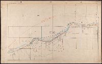
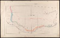
107 colored manuscript railroad maps, detailing the line of the Colorado Midland Railway between Park County and Pitkin and Garfield Counties. The highly detailed maps depict county ranges and townships, survey points and mileage markers, depots, cany...
Subject (Geographic):
Colorado, Aspen (Colo.), Buena Vista (Colo.), Glenwood Springs (Colo.), and Leadville (Colo.)
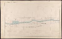
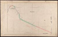
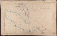