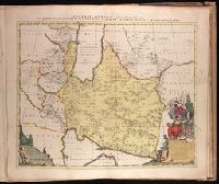
1. Imperii Persici delineatio [cartographic material] Creator: Reelant, Adriaan, 1676-1718 Published / Created: MDCCV [1705] Call Number: 1973 Folio 18 Image Count: 1 Description: BEIN 1973 Folio 18: Backed with paper. Ms. no. "90" in upper right-hand corner. Sheet measures 53.6 x 62.7 cm. No. 82 of 87 maps bound together. Publisher: Ex formis [Pe]tri Schenk Subject (Geographic): Middle East and Iran Found in: Beinecke Rare Book and Manuscript Library > Imperii Persici delineatio [cartographic material]
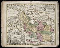
2. Imperii Persici in omnes suas provincias (tam veteribus quam modernis earundem nominibus signatas Creator: Homann, Johann Baptist, 1663-1724 Published / Created: ca. 1724] Call Number: 1975 Folio 31 Image Count: 1 Description: BEIN 1975 Folio 31: Imperfect: edges frayed, with no loss of text. Sheet measures 53.2 x 62.5 cm. No. 39 of 42 maps bound together. Publisher: Johann Baptist Homann Subject (Geographic): Middle East and Iran Found in: Beinecke Rare Book and Manuscript Library > Imperii Persici in omnes suas provincias (tam veteribus quam modernis earundem nominibus signatas) exacte divisi nova tabula geographica / [cartographic material]
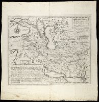
3. [Ibrahim Müteferrika's engraved map of the Persian Empire, showing also the Caucasus, southern Published / Created: 1729?] Call Number: 534 1729 Image Count: 2 Alternative Title: Mameluke Iran Description: BEIN 534 1729: Preliminary record. Publisher: Ibrahim Müteferrika Subject (Geographic): Iran Found in: Beinecke Rare Book and Manuscript Library > [Ibrahim Müteferrika's engraved map of the Persian Empire, showing also the Caucasus, southern Russia, Transcaucasian Turkestan, Iraq and part of Anatolia ... A.H. 1142 - A.D. 1729/30] [cartographic material].