

- None3
You Searched For
« Previous
| 1 - 10 of 19 |
Next »
Search Results
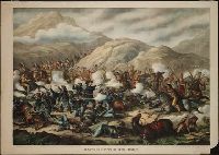
2.
- Published / Created:
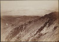
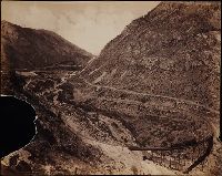
- 1889.
- Call Number:
- BrSides Zc43 889ba
- Image Count:
- 1
- Resource Type:
- still image
- Abstract:
- Print depicts the battle at the Little Big Horn river in Montana. Custer stands in the center of the action firing a pistol with each hand; Native Americans on horseback attacking dismounted U.S. soldiers
- Description:
- BEIN BrSides Zc43 889ba: On sheet 49 x 71 cm. and Title from caption below image. Title continues: June 25th. 1876. -- Gen. Custer, his two brothers, his nephew, and all his men (7th. Cavalry) were killed.
- Publisher:
- Published by Kurz & Allison, Art Publishers
- Subject (Geographic):
- Montana, United States, Montana., and United States.
- Subject (Name):
- Custer, George A. 1839-1876 (George Armstrong), and Custer, George A. 1839-1876. (George Armstrong),
- Subject (Topic):
- Little Bighorn, Battle of the, Mont., 1876 and History
- Found in:
- Beinecke Rare Book and Manuscript Library > Battle of the Big Horn
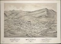
3.
- Creator:
- Glover, E. S. (Eli Sheldon), 1844-1920, artist
- Published / Created:
- 1875.
- Call Number:
- BrSides Zc43 875gL
- Image Count:
- 1
- Resource Type:
- cartographic image and text
- Abstract:
- Print shows a birds-eye view of Helena, Montana, in 1875, looking from the north-east to the south-west
- Description:
- BEIN BrSides Zc43 875gL: Stamped in blue: Library of Congress Washington copyright 187 [completed in manuscript "5"] no. [completed in manuscript "111638"]; overstamped in red: Duplicate. Backed with paper., Title from caption., and Includes index to points of interest and text.
- Publisher:
- C.K. Wells
- Subject (Geographic):
- Helena (Mont.), Montana, and Helena.
- Found in:
- Beinecke Rare Book and Manuscript Library > Birds-eye view of Helena, Montana 1875
4.

- Creator:
- Matteson, Sumner W., 1867-1920
- Published / Created:
- ca. 1899-1903.
- Call Number:
- WA Photos 204
- Container / Volume:
- Box 1 (album)
- Image Count:
- 20
- Abstract:
- Photograph album created by Sumner Matteson from a selection of his photographs of the Southwest, Montana, and Colorado. The photographs, which are captioned in a typed list that accompanies the album, date from 1899 to 1902, and depict a variety of places and events. The majority of the photographs are of the Hopi Indians, their Snake, Antelope, and Flute ceremonies, kiva interiors, as well as weaving, grinding corn, courting, working in fields, making pottery, and marketing at the Moenkopi, Mishongnovi, Shipolovi and Shongopovi Pueblos. There are also photographs of cliff-dwellings at Mesa Verde and Mancos Canyon, Colorado; Canyon de Chelly, Arizona; Pueblo Indians at Isleta and Acoma, New Mexico; Navajo and Ute Indians in New Mexico and Colorado; Penitentes in Abiquiu, New Mexico; and views of wagon trains, Indian encampments, mines, and sheepherding in Montana
- Description:
- Sumner Matteson, a bicycle salesman in Denver who became a photographer, traveled around the West between 1899 and 1903, photographing the Mesa Verde and Pueblo Bonito cliff-dwellings, Navajo Indians, Penitentes in New Mexico, Hopi Snake and Flute ceremonies in Arizona, the Pueblo villages of Acoma and Isleta, Montana wagon trains, and cattle and sheep roundups. He sold his own photographs, wrote articles and provided illustrations for popular magazines, and provided photographs for several books on Southwestern Indians written by others., Accompanied by a contemporary typescript containing captions and often explanatory background for almost all of the photographs in the album. Typescript titled "Index to the Frank Klepetko Album. Photos and Data by Sumner W. Matteson" and signed "Sumner W. Matteson, D.A.C. [Denver Athletic Club] Denver, Colo. Jan. 1903.", Individual photographs are 12 x 17 cm. and smaller., 157 of the photographs are platinum prints., Album and copy prints in 2 boxes., and Copy prints available for every page except the first.
- Subject (Geographic):
- Southwest, New, Montana, New Mexico, Arizona, Abiquiu (N.M.), Acoma (N.M.), Canyon de Chelly National Monument (Ariz.), Colorado, Isleta (N.M.), Mancos Site (Colo.), Mesa Verde National Park (Colo.), Moenkopi Pueblo (Ariz.), and West (U.S.)
- Subject (Name):
- Klepetko, Frank., Matteson, Sumner W., 1867-1920., and Hermanos Penitentes
- Subject (Topic):
- Hopi Indians, Rites and ceremonies, Indians of North America, Cliff-dwellings, Kivas, Navajo Indians, Pueblo Indians, Snake dance, Mines and mineral resources, Sheep ranches, Wool industry, and Religious life and customs
- Found in:
- Beinecke Rare Book and Manuscript Library > Cliff dwellings, pueblo ruins, & Indian life in the South West
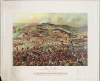
5.
- Creator:
- Hoskins, Gayle (Gayle Porter), 1887-1962, artist
- Published / Created:
- [195-?]
- Call Number:
- WA Prints +142
- Image Count:
- 1
- Resource Type:
- still image
- Abstract:
- Print reproduces an original painting by Gayle P. Hoskins showing an imaginary convergence of battle events in a panoramic, birdseye-view, including Crazy Horse's encircling maneuver and Chief Gall's converging attack from the south
- Description:
- Title from caption below image., Signed in the image: Gayle Hoskins 1953., and Text below caption: Reprinted from The Custer myth by Colonel W.A. Graham, copyright by the Stackpole Company, Harrisburg, Pennsylvania, publishers.
- Publisher:
- Stackpole Co.
- Subject (Geographic):
- Montana.
- Subject (Name):
- Custer, George A. 1839-1876 (George Armstrong),, Crazy Horse, approximately 1842-1877, Gall, Dakota chief, 1840-1894, and Custer, George A. 1839-1876. (George Armstrong),
- Subject (Topic):
- Little Bighorn, Battle of the, Mont., 1876, Lakota Indians, Nothern Cheyenne Indians, and Arapaho Indians
- Found in:
- Beinecke Rare Book and Manuscript Library > Custer's last fight : the Battle of the Little Big Horn, June 25, 1876
6.

- Creator:
- Hoskins, Gayle (Gayle Porter), 1887-1962, artist
- Published / Created:
- [195-?]
- Call Number:
- WA Prints +141
- Image Count:
- 1
- Resource Type:
- still image
- Abstract:
- Print reproduces an original painting by Gayle P. Hoskins showing an imaginary convergence of battle events in a panoramic, birdseye-view, including Crazy Horse's encircling maneuver and Chief Gall's converging attack from the south
- Description:
- Title from caption below image., Signed in the image: Gayle Hoskins 1953., and Text below caption: Reprinted from The Custer myth by Colonel W.A. Graham, copyright by the Stackpole Company, Harrisburg, Pennsylvania, publishers.
- Publisher:
- Stackpole Co.
- Subject (Geographic):
- Montana.
- Subject (Name):
- Custer, George A. 1839-1876 (George Armstrong),, Crazy Horse, approximately 1842-1877, Gall, Dakota chief, 1840-1894, and Custer, George A. 1839-1876. (George Armstrong),
- Subject (Topic):
- Little Bighorn, Battle of the, Mont., 1876, Lakota Indians, Nothern Cheyenne Indians, and Arapaho Indians
- Found in:
- Beinecke Rare Book and Manuscript Library > Custer's last fight : the Battle of the Little Big Horn, June 25, 1876
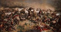
7.
- Creator:
- Mulvany, John, 1839-1906, artist
- Published / Created:
- [1881]
- Call Number:
- BrSides Zc43 881mu
- Image Count:
- 1
- Resource Type:
- still image
- Abstract:
- Print depicts Custer and dismounted U.S. soldiers attacked by mounted Native Americans; Custer, standing in center, pistol raised in his right hand, saber in his left
- Description:
- BEIN BrSides Zc43 881mu: Imperfect: Trimmed to image only; wanting caption title and attributions., Title from caption below image., and Signed in plate lower right corner: "Jno. Mulvaney 1881" and printed in plate lower left: copyrighted.
- Publisher:
- Chicago Litho. & Engraving Co.
- Subject (Geographic):
- United States, Montana., and United States.
- Subject (Name):
- Custer, George A. 1839-1876 (George Armstrong), and Custer, George A. 1839-1876. (George Armstrong),
- Subject (Topic):
- Little Bighorn, Battle of the, Mont., 1876 and Battles
- Found in:
- Beinecke Rare Book and Manuscript Library > Custer's last rally : battle of the Little Big Horn, June 25, 1876
8.
- Published / Created:
- 1874-1898.
- Call Number:
- WA Photos Folio 1
- Container / Volume:
- Box 2
- Image Count:
- 26
- Abstract:
- Photographs created from mammoth plate negatives primarily by photographers Carleton E. Watkins and William Henry Jackson of various locations in the American West, primarily in the states of California, Colorado, and Oregon, as well as Arizona, Montana, Utah, Washington, and Wyoming Territories, ca. 1874-1898, Photographs by Watkins consist of images created in the states of California and Oregon, and in Arizona, Montana, Utah, Washington, and Wyoming Territories, ca. 1874-1890, An image created by Watkins of Tombstone, Arizona Territory shows the Old South Shaft Ore Quarry of the Tough Nut Mine with a view of the town, the Dragoon Mountains, and the Cochise Stronghold in the distance, 1880, Images created by Watkins in California consist primarily of locations in Yosemite National Park, including Half Dome, Sentinel Rock, Tutocanula Pass (consisting of El Capitan and Cathedral Rocks cliff), and views of the Yosemite Valley from the Mariposa Trail and Eagle Point, 1878-1881. Other images from California include two different views from the top of Round Top Mountain, with one of the images showing a view of the Blue Lakes and the other the Mokelumne River, 1879; views in the vicinity of San Gabriel showing residences and wine houses of the Lake Vineyard, near the Sierra Madre Mountains and a date palm tree on the grounds of the Mission San Gabriel Arcangel, ca. 1874-1880; a view of the Carmel Valley from the Mission Road, Monterey; and a view of a waterfall, probably the Palisades Falls on the North Fork American River at Soda Springs, ca. 1874-1880, Images created by Watkins in Marysville, Montana Territory, consist of a view of the town, three interior views of a mill, and a view of the Drumlummon Mine and the Maskelyne Tunnel, 1884-1885 or 1890, Images created by Watkins along the Columbia River, Oregon, consist of views of rock bluffs along the river, a Native American village located at the Dalles, a winter view of the river with snow-covered shores, and a view of the Tooth Bridge and Eagle Creek Crossing, 1884-1885, Images created by Watkins in Washington Territory include a view of the Spokane Falls of the Spokane River, a mill in Port Ludlow, and ships at a dock in Port Madison on Bainbridge Island, 1882, Images created by Watkins of geothermal features in Yellowstone National Park, Wyoming Territory, consist of Giant Geyser, Grotto Geyser, Old Faithful Geyser, and Pulpit Terrace, 1884-1885, A majority of the images created by William Henry Jackson depict locations and geological features in Colorado, while other images show locations in Utah, Idaho, New Mexico, and Oregon, 1878-1898, Images from El Paso County, Colorado, created by Jackson include geological features in the Garden of the Gods, such as Cathedral Spires, Gate Rock, Tower of Babel, and the abutting Seal Rock and Bear Rock, with many images showing Pikes Peak in the distance; a view of Monument Park showing eroded sandstone rock formations; a view of a waterfall identified as Castle Falls, on North Cheyenne Creek in North Cheyenne Canyon; a view of Phoebe's Arch, near Palmer Lake; a view of Sheltered Falls on Ruxton Creek; a view of foothills and snow on Pikes Peak and Austin Bluffs; a view of Seven Falls (also known as Cheyenne Falls) on South Cheyenne Creek in South Cheyenne Canyon, and a view of Fountain Creek near Colorado City with a snow-covered Pikes Peak in the distance, Images from Gunnison County, Colorado, created by Jackson include a view of the Curecanti Needle rock formation in the Black Canyon with the Gunnison River and the railroad of the Denver and Rio Grande Railroad Company, and a view of a man standing on a rock by the Gunnison River near Sapinero, Two images in the Royal Gorge, Fremont County, Colorado, created by Jackson show the Denver and Rio Grande Railroad near the Arkansas River, with one of the images showing a suspension bridge known as Hanging Bridge, Other images created by Jackson in Colorado include a view of the city of Glenwood Springs in Garfield County and the stone and wood frame buildings at the Yampah Hot Springs bathhouse and pool; a view of the Georgetown Loop and tracks of the Colorado Central Railroad Company in Clear Creek Canyon in Clear Creek County; a view of Cathedral Spires and the Platte Canyon of the South Platte River with tracks of the Denver, South Park, and Pacific Railroad Company in Jefferson County; a view of people sitting in a horse-drawn carriage on a dirt road in Ute Pass, showing Twin Creek and Rainbow Falls, in Teller County; and a view of Sierra Blanca mountains, a stream and railroad tracks, possibly in Costilla County, Images created by Jackson in Utah include a view of Bridal Veil Falls on the Provo River in Provo Canyon, Utah County; and a view in the vicinity of Echo, depicting men standing and sitting on a rock formation identified as Pulpit Rock, Summit County, Other images created by Jackson include a view of the Twin Falls waterfall on the Snake River, Jerome County, Idaho; a view of Rio de los Pinos and rock formations in the Toltec Gorge, Rio Arriba County, New Mexico; and a view of Multnomah Falls on Multnomah Creek in Multnomah County, Oregon, and The collection includes an additional view created by F. Jay Haynes that shows an unidentified body of water beside two railroad tracks and a telegraph line; and an image probably by Watkins or Haynes that depicts an interior view of large industrial machinery in a brick building
- Description:
- A mammoth plate is a photographic negative plate, 18 by 21 inches (53.5 x 45.7 cm.) or larger, from which photographic prints are made through contact printing., Title devised by cataloger., Captions inscribed in the negatives created by Jackson., Manuscript inscription on the recto and verso of several photographic prints., and Photographs previously bound in a volume with the spine title "Photographs by Ezra Meeker and W. H. Jackson." The original boards and spine are filed with the collection.
- Subject (Geographic):
- Wyoming, Montana, West (U.S.), Arizona, Arkansas River, Austin Bluffs (Colo.), Black Canyon of the Gunnison (Colo.), Blue Lakes (Calif.), Bridal Veil Falls (Utah), California, Cathedral Rocks (Calif.), Cathedral Spires (El Paso County, Colo.), Cathedral Spires (Jefferson County, Colo.), Clear Creek Canyon (Colo.), Clear Creek County (Colo.), Cochise Stronghold (Ariz.), Colorado, Columbia River, Costilla County (Colo.), Curecanti Needle (Colo.), Dalles (Or.), Dragoon Mountains (Ariz.), Drumlummon Mine (Mont.), Eagle Creek (Or.), Echo (Utah), El Capitan (Calif.), El Paso County (Colo.), Fountain Creek (Colo.), Fremont County (Colo.), Garden of the Gods (Colorado Springs, Colo.), Garfield County (Colo.), Gate Rock (El Paso County, Colo.), Giant Geyser (Wyo.), Glenwood Springs (Colo.), Grotto Geyser (Wyo.), Gunnison County (Colo.), Gunnison River (Colo.), Half Dome (Calif.), Jefferson County (Colo.), Jerome County (Idaho), Lake Vineyard (San Gabriel, Calif.), Marysville (Lewis and Clark County, Mont.), Mokelumne River (Calif.), Monument Park (El Paso County, Colo.), Multnomah County (Or.), Multnomah Creek (Or.), Multnomah Falls (Or.), North Cheyenne Canyon (Colo.), North Cheyenne Creek (Colo.), North Fork American River (Calif.), Old Faithful Geyser (Wyo.), Oregon, Palisades Falls, Pikes Peak (Colo.), Platte Canyon (Colo.), Port Ludlow (Wash.), Port Madison (Bainbridge Island, Wash.), Provo Canyon (Utah), Provo River (Utah), Pulpit Rock (Utah), Pulpit Terrace (Wyo.), Rainbow Falls (Colo.), Rio Arriba County (N.M.), Rio de los Pinos (Colo. and N.M.), Round Top Mountain (Calif.), Royal Gorge (Colo.), San Gabriel (Calif.), Sentinel Rock (Calif.), Seven Falls (Colo.), Sierra Blanca (Colo.), Snake River (Wyo.-Wash.), Soda Springs (Calif.), South Cheyenne Canyon (Colo.), South Cheyenne Creek (Colo.), South Platte River (Colo. and Neb.), Spokane (Wash.), Spokane River (Idaho and Wash.), Teller County (Colo.), Toltec Gorge (N.M.), Tombstone (Ariz.), Tombstone Region (Ariz.), Twin Creek (Colo.), Twin Falls (Idaho : Waterfalls), Utah, Ute Pass (Teller County, Colo.), Washington (State), Yampah Hot Springs (Colo.), Yellowstone National Park, Yosemite National Park (Calif.), and Yosemite Valley (Calif.)
- Subject (Name):
- Haynes, F. Jay 1853-1921. (Frank Jay),, Jackson, William Henry, 1843-1942., Meeker, Ezra, 1830-1928., Watkins, Carleton E., 1829-1916., Colorado Central Railroad Company, Denver and Rio Grande Railroad Company, Denver, South Park, and Pacific Railroad Company, Mission San Gabriel Arcangel (San Gabriel, Calif.), and Tough Nut Mine
- Subject (Topic):
- Geysers, Landscape photography, Mineral industries, and Railroads
- Found in:
- Beinecke Rare Book and Manuscript Library > Mammoth plate photographs of the North American West
9.
- Published / Created:
- 1874-1898.
- Call Number:
- WA Photos Folio 1
- Container / Volume:
- Box 3
- Image Count:
- 28
- Abstract:
- Photographs created from mammoth plate negatives primarily by photographers Carleton E. Watkins and William Henry Jackson of various locations in the American West, primarily in the states of California, Colorado, and Oregon, as well as Arizona, Montana, Utah, Washington, and Wyoming Territories, ca. 1874-1898, Photographs by Watkins consist of images created in the states of California and Oregon, and in Arizona, Montana, Utah, Washington, and Wyoming Territories, ca. 1874-1890, An image created by Watkins of Tombstone, Arizona Territory shows the Old South Shaft Ore Quarry of the Tough Nut Mine with a view of the town, the Dragoon Mountains, and the Cochise Stronghold in the distance, 1880, Images created by Watkins in California consist primarily of locations in Yosemite National Park, including Half Dome, Sentinel Rock, Tutocanula Pass (consisting of El Capitan and Cathedral Rocks cliff), and views of the Yosemite Valley from the Mariposa Trail and Eagle Point, 1878-1881. Other images from California include two different views from the top of Round Top Mountain, with one of the images showing a view of the Blue Lakes and the other the Mokelumne River, 1879; views in the vicinity of San Gabriel showing residences and wine houses of the Lake Vineyard, near the Sierra Madre Mountains and a date palm tree on the grounds of the Mission San Gabriel Arcangel, ca. 1874-1880; a view of the Carmel Valley from the Mission Road, Monterey; and a view of a waterfall, probably the Palisades Falls on the North Fork American River at Soda Springs, ca. 1874-1880, Images created by Watkins in Marysville, Montana Territory, consist of a view of the town, three interior views of a mill, and a view of the Drumlummon Mine and the Maskelyne Tunnel, 1884-1885 or 1890, Images created by Watkins along the Columbia River, Oregon, consist of views of rock bluffs along the river, a Native American village located at the Dalles, a winter view of the river with snow-covered shores, and a view of the Tooth Bridge and Eagle Creek Crossing, 1884-1885, Images created by Watkins in Washington Territory include a view of the Spokane Falls of the Spokane River, a mill in Port Ludlow, and ships at a dock in Port Madison on Bainbridge Island, 1882, Images created by Watkins of geothermal features in Yellowstone National Park, Wyoming Territory, consist of Giant Geyser, Grotto Geyser, Old Faithful Geyser, and Pulpit Terrace, 1884-1885, A majority of the images created by William Henry Jackson depict locations and geological features in Colorado, while other images show locations in Utah, Idaho, New Mexico, and Oregon, 1878-1898, Images from El Paso County, Colorado, created by Jackson include geological features in the Garden of the Gods, such as Cathedral Spires, Gate Rock, Tower of Babel, and the abutting Seal Rock and Bear Rock, with many images showing Pikes Peak in the distance; a view of Monument Park showing eroded sandstone rock formations; a view of a waterfall identified as Castle Falls, on North Cheyenne Creek in North Cheyenne Canyon; a view of Phoebe's Arch, near Palmer Lake; a view of Sheltered Falls on Ruxton Creek; a view of foothills and snow on Pikes Peak and Austin Bluffs; a view of Seven Falls (also known as Cheyenne Falls) on South Cheyenne Creek in South Cheyenne Canyon, and a view of Fountain Creek near Colorado City with a snow-covered Pikes Peak in the distance, Images from Gunnison County, Colorado, created by Jackson include a view of the Curecanti Needle rock formation in the Black Canyon with the Gunnison River and the railroad of the Denver and Rio Grande Railroad Company, and a view of a man standing on a rock by the Gunnison River near Sapinero, Two images in the Royal Gorge, Fremont County, Colorado, created by Jackson show the Denver and Rio Grande Railroad near the Arkansas River, with one of the images showing a suspension bridge known as Hanging Bridge, Other images created by Jackson in Colorado include a view of the city of Glenwood Springs in Garfield County and the stone and wood frame buildings at the Yampah Hot Springs bathhouse and pool; a view of the Georgetown Loop and tracks of the Colorado Central Railroad Company in Clear Creek Canyon in Clear Creek County; a view of Cathedral Spires and the Platte Canyon of the South Platte River with tracks of the Denver, South Park, and Pacific Railroad Company in Jefferson County; a view of people sitting in a horse-drawn carriage on a dirt road in Ute Pass, showing Twin Creek and Rainbow Falls, in Teller County; and a view of Sierra Blanca mountains, a stream and railroad tracks, possibly in Costilla County, Images created by Jackson in Utah include a view of Bridal Veil Falls on the Provo River in Provo Canyon, Utah County; and a view in the vicinity of Echo, depicting men standing and sitting on a rock formation identified as Pulpit Rock, Summit County, Other images created by Jackson include a view of the Twin Falls waterfall on the Snake River, Jerome County, Idaho; a view of Rio de los Pinos and rock formations in the Toltec Gorge, Rio Arriba County, New Mexico; and a view of Multnomah Falls on Multnomah Creek in Multnomah County, Oregon, and The collection includes an additional view created by F. Jay Haynes that shows an unidentified body of water beside two railroad tracks and a telegraph line; and an image probably by Watkins or Haynes that depicts an interior view of large industrial machinery in a brick building
- Description:
- A mammoth plate is a photographic negative plate, 18 by 21 inches (53.5 x 45.7 cm.) or larger, from which photographic prints are made through contact printing., Title devised by cataloger., Captions inscribed in the negatives created by Jackson., Manuscript inscription on the recto and verso of several photographic prints., and Photographs previously bound in a volume with the spine title "Photographs by Ezra Meeker and W. H. Jackson." The original boards and spine are filed with the collection.
- Subject (Geographic):
- Wyoming, Montana, West (U.S.), Arizona, Arkansas River, Austin Bluffs (Colo.), Black Canyon of the Gunnison (Colo.), Blue Lakes (Calif.), Bridal Veil Falls (Utah), California, Cathedral Rocks (Calif.), Cathedral Spires (El Paso County, Colo.), Cathedral Spires (Jefferson County, Colo.), Clear Creek Canyon (Colo.), Clear Creek County (Colo.), Cochise Stronghold (Ariz.), Colorado, Columbia River, Costilla County (Colo.), Curecanti Needle (Colo.), Dalles (Or.), Dragoon Mountains (Ariz.), Drumlummon Mine (Mont.), Eagle Creek (Or.), Echo (Utah), El Capitan (Calif.), El Paso County (Colo.), Fountain Creek (Colo.), Fremont County (Colo.), Garden of the Gods (Colorado Springs, Colo.), Garfield County (Colo.), Gate Rock (El Paso County, Colo.), Giant Geyser (Wyo.), Glenwood Springs (Colo.), Grotto Geyser (Wyo.), Gunnison County (Colo.), Gunnison River (Colo.), Half Dome (Calif.), Jefferson County (Colo.), Jerome County (Idaho), Lake Vineyard (San Gabriel, Calif.), Marysville (Lewis and Clark County, Mont.), Mokelumne River (Calif.), Monument Park (El Paso County, Colo.), Multnomah County (Or.), Multnomah Creek (Or.), Multnomah Falls (Or.), North Cheyenne Canyon (Colo.), North Cheyenne Creek (Colo.), North Fork American River (Calif.), Old Faithful Geyser (Wyo.), Oregon, Palisades Falls, Pikes Peak (Colo.), Platte Canyon (Colo.), Port Ludlow (Wash.), Port Madison (Bainbridge Island, Wash.), Provo Canyon (Utah), Provo River (Utah), Pulpit Rock (Utah), Pulpit Terrace (Wyo.), Rainbow Falls (Colo.), Rio Arriba County (N.M.), Rio de los Pinos (Colo. and N.M.), Round Top Mountain (Calif.), Royal Gorge (Colo.), San Gabriel (Calif.), Sentinel Rock (Calif.), Seven Falls (Colo.), Sierra Blanca (Colo.), Snake River (Wyo.-Wash.), Soda Springs (Calif.), South Cheyenne Canyon (Colo.), South Cheyenne Creek (Colo.), South Platte River (Colo. and Neb.), Spokane (Wash.), Spokane River (Idaho and Wash.), Teller County (Colo.), Toltec Gorge (N.M.), Tombstone (Ariz.), Tombstone Region (Ariz.), Twin Creek (Colo.), Twin Falls (Idaho : Waterfalls), Utah, Ute Pass (Teller County, Colo.), Washington (State), Yampah Hot Springs (Colo.), Yellowstone National Park, Yosemite National Park (Calif.), and Yosemite Valley (Calif.)
- Subject (Name):
- Haynes, F. Jay 1853-1921. (Frank Jay),, Jackson, William Henry, 1843-1942., Meeker, Ezra, 1830-1928., Watkins, Carleton E., 1829-1916., Colorado Central Railroad Company, Denver and Rio Grande Railroad Company, Denver, South Park, and Pacific Railroad Company, Mission San Gabriel Arcangel (San Gabriel, Calif.), and Tough Nut Mine
- Subject (Topic):
- Geysers, Landscape photography, Mineral industries, and Railroads
- Found in:
- Beinecke Rare Book and Manuscript Library > Mammoth plate photographs of the North American West
10.
- Published / Created:
- 1874-1898.
- Call Number:
- WA Photos Folio 1
- Container / Volume:
- Box 4
- Image Count:
- 28
- Abstract:
- Photographs created from mammoth plate negatives primarily by photographers Carleton E. Watkins and William Henry Jackson of various locations in the American West, primarily in the states of California, Colorado, and Oregon, as well as Arizona, Montana, Utah, Washington, and Wyoming Territories, ca. 1874-1898, Photographs by Watkins consist of images created in the states of California and Oregon, and in Arizona, Montana, Utah, Washington, and Wyoming Territories, ca. 1874-1890, An image created by Watkins of Tombstone, Arizona Territory shows the Old South Shaft Ore Quarry of the Tough Nut Mine with a view of the town, the Dragoon Mountains, and the Cochise Stronghold in the distance, 1880, Images created by Watkins in California consist primarily of locations in Yosemite National Park, including Half Dome, Sentinel Rock, Tutocanula Pass (consisting of El Capitan and Cathedral Rocks cliff), and views of the Yosemite Valley from the Mariposa Trail and Eagle Point, 1878-1881. Other images from California include two different views from the top of Round Top Mountain, with one of the images showing a view of the Blue Lakes and the other the Mokelumne River, 1879; views in the vicinity of San Gabriel showing residences and wine houses of the Lake Vineyard, near the Sierra Madre Mountains and a date palm tree on the grounds of the Mission San Gabriel Arcangel, ca. 1874-1880; a view of the Carmel Valley from the Mission Road, Monterey; and a view of a waterfall, probably the Palisades Falls on the North Fork American River at Soda Springs, ca. 1874-1880, Images created by Watkins in Marysville, Montana Territory, consist of a view of the town, three interior views of a mill, and a view of the Drumlummon Mine and the Maskelyne Tunnel, 1884-1885 or 1890, Images created by Watkins along the Columbia River, Oregon, consist of views of rock bluffs along the river, a Native American village located at the Dalles, a winter view of the river with snow-covered shores, and a view of the Tooth Bridge and Eagle Creek Crossing, 1884-1885, Images created by Watkins in Washington Territory include a view of the Spokane Falls of the Spokane River, a mill in Port Ludlow, and ships at a dock in Port Madison on Bainbridge Island, 1882, Images created by Watkins of geothermal features in Yellowstone National Park, Wyoming Territory, consist of Giant Geyser, Grotto Geyser, Old Faithful Geyser, and Pulpit Terrace, 1884-1885, A majority of the images created by William Henry Jackson depict locations and geological features in Colorado, while other images show locations in Utah, Idaho, New Mexico, and Oregon, 1878-1898, Images from El Paso County, Colorado, created by Jackson include geological features in the Garden of the Gods, such as Cathedral Spires, Gate Rock, Tower of Babel, and the abutting Seal Rock and Bear Rock, with many images showing Pikes Peak in the distance; a view of Monument Park showing eroded sandstone rock formations; a view of a waterfall identified as Castle Falls, on North Cheyenne Creek in North Cheyenne Canyon; a view of Phoebe's Arch, near Palmer Lake; a view of Sheltered Falls on Ruxton Creek; a view of foothills and snow on Pikes Peak and Austin Bluffs; a view of Seven Falls (also known as Cheyenne Falls) on South Cheyenne Creek in South Cheyenne Canyon, and a view of Fountain Creek near Colorado City with a snow-covered Pikes Peak in the distance, Images from Gunnison County, Colorado, created by Jackson include a view of the Curecanti Needle rock formation in the Black Canyon with the Gunnison River and the railroad of the Denver and Rio Grande Railroad Company, and a view of a man standing on a rock by the Gunnison River near Sapinero, Two images in the Royal Gorge, Fremont County, Colorado, created by Jackson show the Denver and Rio Grande Railroad near the Arkansas River, with one of the images showing a suspension bridge known as Hanging Bridge, Other images created by Jackson in Colorado include a view of the city of Glenwood Springs in Garfield County and the stone and wood frame buildings at the Yampah Hot Springs bathhouse and pool; a view of the Georgetown Loop and tracks of the Colorado Central Railroad Company in Clear Creek Canyon in Clear Creek County; a view of Cathedral Spires and the Platte Canyon of the South Platte River with tracks of the Denver, South Park, and Pacific Railroad Company in Jefferson County; a view of people sitting in a horse-drawn carriage on a dirt road in Ute Pass, showing Twin Creek and Rainbow Falls, in Teller County; and a view of Sierra Blanca mountains, a stream and railroad tracks, possibly in Costilla County, Images created by Jackson in Utah include a view of Bridal Veil Falls on the Provo River in Provo Canyon, Utah County; and a view in the vicinity of Echo, depicting men standing and sitting on a rock formation identified as Pulpit Rock, Summit County, Other images created by Jackson include a view of the Twin Falls waterfall on the Snake River, Jerome County, Idaho; a view of Rio de los Pinos and rock formations in the Toltec Gorge, Rio Arriba County, New Mexico; and a view of Multnomah Falls on Multnomah Creek in Multnomah County, Oregon, and The collection includes an additional view created by F. Jay Haynes that shows an unidentified body of water beside two railroad tracks and a telegraph line; and an image probably by Watkins or Haynes that depicts an interior view of large industrial machinery in a brick building
- Description:
- A mammoth plate is a photographic negative plate, 18 by 21 inches (53.5 x 45.7 cm.) or larger, from which photographic prints are made through contact printing., Title devised by cataloger., Captions inscribed in the negatives created by Jackson., Manuscript inscription on the recto and verso of several photographic prints., and Photographs previously bound in a volume with the spine title "Photographs by Ezra Meeker and W. H. Jackson." The original boards and spine are filed with the collection.
- Subject (Geographic):
- Wyoming, Montana, West (U.S.), Arizona, Arkansas River, Austin Bluffs (Colo.), Black Canyon of the Gunnison (Colo.), Blue Lakes (Calif.), Bridal Veil Falls (Utah), California, Cathedral Rocks (Calif.), Cathedral Spires (El Paso County, Colo.), Cathedral Spires (Jefferson County, Colo.), Clear Creek Canyon (Colo.), Clear Creek County (Colo.), Cochise Stronghold (Ariz.), Colorado, Columbia River, Costilla County (Colo.), Curecanti Needle (Colo.), Dalles (Or.), Dragoon Mountains (Ariz.), Drumlummon Mine (Mont.), Eagle Creek (Or.), Echo (Utah), El Capitan (Calif.), El Paso County (Colo.), Fountain Creek (Colo.), Fremont County (Colo.), Garden of the Gods (Colorado Springs, Colo.), Garfield County (Colo.), Gate Rock (El Paso County, Colo.), Giant Geyser (Wyo.), Glenwood Springs (Colo.), Grotto Geyser (Wyo.), Gunnison County (Colo.), Gunnison River (Colo.), Half Dome (Calif.), Jefferson County (Colo.), Jerome County (Idaho), Lake Vineyard (San Gabriel, Calif.), Marysville (Lewis and Clark County, Mont.), Mokelumne River (Calif.), Monument Park (El Paso County, Colo.), Multnomah County (Or.), Multnomah Creek (Or.), Multnomah Falls (Or.), North Cheyenne Canyon (Colo.), North Cheyenne Creek (Colo.), North Fork American River (Calif.), Old Faithful Geyser (Wyo.), Oregon, Palisades Falls, Pikes Peak (Colo.), Platte Canyon (Colo.), Port Ludlow (Wash.), Port Madison (Bainbridge Island, Wash.), Provo Canyon (Utah), Provo River (Utah), Pulpit Rock (Utah), Pulpit Terrace (Wyo.), Rainbow Falls (Colo.), Rio Arriba County (N.M.), Rio de los Pinos (Colo. and N.M.), Round Top Mountain (Calif.), Royal Gorge (Colo.), San Gabriel (Calif.), Sentinel Rock (Calif.), Seven Falls (Colo.), Sierra Blanca (Colo.), Snake River (Wyo.-Wash.), Soda Springs (Calif.), South Cheyenne Canyon (Colo.), South Cheyenne Creek (Colo.), South Platte River (Colo. and Neb.), Spokane (Wash.), Spokane River (Idaho and Wash.), Teller County (Colo.), Toltec Gorge (N.M.), Tombstone (Ariz.), Tombstone Region (Ariz.), Twin Creek (Colo.), Twin Falls (Idaho : Waterfalls), Utah, Ute Pass (Teller County, Colo.), Washington (State), Yampah Hot Springs (Colo.), Yellowstone National Park, Yosemite National Park (Calif.), and Yosemite Valley (Calif.)
- Subject (Name):
- Haynes, F. Jay 1853-1921. (Frank Jay),, Jackson, William Henry, 1843-1942., Meeker, Ezra, 1830-1928., Watkins, Carleton E., 1829-1916., Colorado Central Railroad Company, Denver and Rio Grande Railroad Company, Denver, South Park, and Pacific Railroad Company, Mission San Gabriel Arcangel (San Gabriel, Calif.), and Tough Nut Mine
- Subject (Topic):
- Geysers, Landscape photography, Mineral industries, and Railroads
- Found in:
- Beinecke Rare Book and Manuscript Library > Mammoth plate photographs of the North American West