Souvenir views of Ogden, Utah and nearby points of interest, including Washington Avenue, 25th Street, the Union Depot in Ogden, the Mormon Tabernacle, the Thomas D. Dee Memorial Hospital, and the Carnegie Library. There are also views of the Power Dam, Narrows, and Falls in Ogden Canyon, the Bear River Canyon, Echo Canyon, Pulpit Rock and Ben Lomond, Mount Ogden seen from Lester Park, and the Devil's Slide in Weber Canyon
Description:
Captions on prints. Two images are credited to D. S. Spencer. The set is packaged in a cardboard wrapper suitable for mailing.
Viewbook of mounted photographic prints compiled by the George W. Williams & Company, fertilizer merchants, ca. 1869. A photographic print appears on the recto of each mount that depicts an advertisement for Carolina Fertilizer with a letterpress testimonial below it. The verso of each mount carries a photographic print of an image created by Andrew J. Russell. The exception is the last mount, which carries a photographic advertisement for BD Sea Fowl Guano on the recto of the mount and no photographic print on the verso. The images by Russell document landscape views and buildings along the Union Pacific Railroad in Nebraska, Wyoming, and Utah, ca. 1867-1869. Many images of landscapes include men and women posited in the terrain to provide scale, An image shows a view of Echo, Utah, as well as rock outcroppings in its vicinity, including Hanging Rock, Monument Rock, and Sphinx Rock, Images of locations in the Weber River Valley, Utah, include views of Coalville city, Devil's Gate, Tunnel No. 4, Bridge No. 32, and of the Mormon Turnpike Bridge at the mouth of the canyon, Images of Wyoming include views of a large windmill at Laramie; Granite Canyon from a water tank; High Bluffs in the Black Buttes area; and an overview of the Laramie River Valley, as well as railroad cuts consisting of the Burning Rock Cut and Hall's Cut (identified in a caption as the Great Mountain Pass)., An image of Omaha, Nebraska, shows a street leading to the Missouri River, An image shows a group of people during the laying of the last rail connecting the Union Pacific Railroad and Central Pacific Railroad on May 10, 1869, near Promontory, Utah, and Sixteen plates without mounted photographic prints in the volume contain graphical advertisements for the products of the George W. Williams Company including BD Sea Fowl Guano, Bradley's Super Phosphate of Lime, C. C. Coe's Ammoniated Super Phosphate of Lime, Carolina Fertilizer, and Palmetto Soluble Acid Phosphate, as well as powdered raw bones and dissolved unburnt bones
Description:
Title from cover., Autograph on front board of Frank E. Taylor., Twenty photographs of the west are reduced images from Andrew J. Russell's, The Great West illustrated . . . New York, 1869., and Photographic prints measure 13 x 7 cm.
Publisher:
s.n.
Subject (Geographic):
United States., West (U.S.), Coalville (Utah), Echo (Utah), Laramie (Wyo.), Missouri River, Nebraska, Omaha (Neb.), Salt Lake City (Utah), Utah, Weber River Valley (Utah), and Wyoming
Subject (Name):
Russell, Andrew J., Williams, George Walton, 1820-1903., Young, Brigham, 1801-1877, Beehive House (Salt Lake City, Utah), Central Pacific Railroad Company, Lion House (Salt Lake City, Utah), Tabernacle (Salt Lake City, Utah), and Union Pacific Railroad Company
Subject (Topic):
Homes and haunts, Advertising, Agriculture, Fertilizer industry, and Railroads
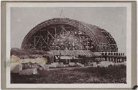
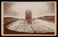
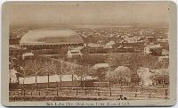
Photograph album of cabinet card views of Salt Lake City, Fort Douglas, Green River and Ogden, Utah, and studio portraits of Ute and Sioux Indians. Salt Lake City views include the Triumphal Arch, the Eagle Gate, the City and County Building, the Mormon Tabernacle under construction, Brigham Young's Schoolhouse, Brigham Young's grave, and the Old Curiosity Shop, and colored views of the Salt Air Palace, the City and County buiding, and the Brighton Hotel in Silver Lake, There are also portraits of Major John Gilbert, Joseph and Hyrum Smith, George Cannon, Heber J. Grant, and Brigham Young, and Most photographs are by C.R. Savage, with twelve images by Sainsbury & Johnson, one composite image showing stages in the construction of the Tabernacle by Chas. W. Carter, and a stereocard by Halsey & Coffin. Some cabinet cards are from the Bureau of Information and Church Literature of the Mormon Church
Description:
Cabinet cards, cartes-de-visite (1) and stereographs (5), many with advertisments on versos, some accompanied by manuscript captions. and Accompanied by a container list (in box 1).
Subject (Geographic):
Utah, Salt Lake City (Utah), Fort Douglas (Utah), Green River (Utah), and Ogden (Utah)
Subject (Topic):
Indians of North America, Ute Indians, Dakota Indians, and Mormons
Photograph album of copy prints from original photographs and artwork, many depicting views of Salt Lake City, including the Deseret News, the Tithing Office, Beehive and Lion Houses, East Temple Street, Main Street, Garfield Beach, the Salt Palace, the Great Salt Lake, the theatre, the studio of photographers Savage & Ottinger, and a Pioneer Day Procession in 1882, There are also copy prints of views of Provo, Utah, and of Marysville, Timbuctoo, and Smartsville, California. Views in La Porte, California depict ski races and horses shod with "snow shoes," and hydraulic mining scenes. In Wyoming there are views of the ruins of Fort Bridger, and in Nevada an unidentified town whose streets are decorated with presidential election banners, Originals from which the copy prints were made date roughly between 1850 and 1890, In addition, there are views of New York, copy prints of several western maps and of various documents relating to the pony express, and of ten paintings by "Ottinger.", and Many views in Salt Lake City are credited to C.R. Savage or Savage & Ottinger
Description:
Individual prints are 31.5 x 20.2 cm. or smaller. Most are accompanied by manuscript captions.
Subject (Geographic):
Utah, California, Provo (Utah), Salt Lake City (Utah), Marysville (Calif.), Timbuctoo (Calif.), La Porte (Calif.), Smartsville (Calif.), Wyoming, Fort Bridger (Wyo.), and Nevada
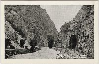
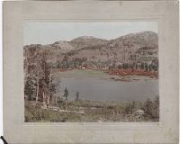
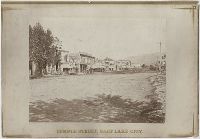
Photographic prints of images created by Andrew Joseph Russell of locations in Utah, Wyoming, California, and Nebraska, ca. 1867-1869. The bound album contains the same images represented in the loose photographic prints. the loose photographic prints were previously bound in a deteriorating leather album with spine title "Views in Salt Lake." The loose photographic prints were foliated before the album was disbound album, Images of locations and structures related to Brigham Young in Utah include views of his residences, known as the Beehive House and Lion House in Salt Lake City; one of these images includes the foundation for the Salt Lake Temple in the foreground. Images of other structures related to Young include his bathhouse located at Warm Sulphur Springs, Salt Lake City, and a view of his cotton and woolen mills in Parley Canyon with the Wasatch Range in the distance, Images of locations in Salt Lake City, Utah, include views of the Tabernacle, the Salt Lake Theatre, Zion's Cooperative Mercantile Institution, and an overview of Temple Street that shows businesses, Images of locations in Echo, Utah, and its vicinity include an overview of the city from the south, as well as several rock formations, including Conglomerate Peaks, Hanging Rock, Sentinel Rock, and Sphinx Rock, Images of locations in Echo Canyon, Utah, and its vicinity include views of several rock outcroppings, including Death's Rock, Finger Rock, and Rock Great Eastern. Several images document Tunnel No. 2 (also known as Echo Tunnel or Wahsatch No. 2) for the Union Pacific Railroad Company, and includes an image of a tunnel entrance, Images of the Weber River and Weber Canyon (also known as the Weber River Valley or Weber Valley), Utah, include views of Coalville; a location on the river near Heneferville (which became Henefer); a vista from Witch Rocks; construction of a wooden bridge across the Weber River at Devil's Gate; a view of Devil's Gate without a bridge; and a view from a ridge of the canyon that shows both entrances to Tunnel No. 3 and two railroad bridges. An image also documents the One Thousand Mile Tree, located in the canyon at a distance one thousand miles west of Omaha, Nebraska, Views of Wilhelmina Pass in Weber Canyon (also known as the Narrows of Weber Canyon), include a distant view of Serrated Rocks (also known as Devil's Slide); a view below a railroad bridge, and an overview of the canyon, Images of locations in the Uinta Mountains, Utah, include a view of Moore's Lake at the head of the Bear River; a view of a man identified as the old trapper in camp beside the Bear River; and a view of the Lake of the Sounding Shore, Images of other locations in Utah include a view of a wooden trestle near Promontory, and a view of Ripple Lake in White Pine Canyon near Park City, Images of locations in the vicinity of Dale Creek, near Sherman and the Laramie Mountains in Wyoming include a view of the Dale Creek Trestle, a wooden railroad trestle bridge; a view of Medicine Bow Mountain; a view of Skull Rock near Sherman Station; a view of Camel Rocks (also known as Granite Rock) near Buford; a view of Devil's Gate in the canyon of Dale Creek; a view of Grizzly Peak from near Evans' Pass; and a view of the source of the Laramie River in the Laramie Mountains, Images of the Green River Valley in Wyoming include a view of the Green River Bridge, a wooden bridge across the Green River with Citadel Rock in the distance; as well as discrete views of rock outcroppings, including Smith's Buttes and Castle Rock, Images of rock outcroppings at various locations throughout Wyoming include views of the High Bluffs near Black Buttes; Church Buttes near Fort Bridger; and Dial Rock in the Laramie Basin, Images of locations in Nebraska include views of a wooden bridge that crosses the North Platte River at its junction with the South Platte River east of the city of North Platte, and a view of the Loup Fork Bridge across Loup Fork of the Platte River, and Images of California include a view from a summit of the Sierra Nevada mountain range with snow sheds in the foreground and Donner Lake in the distance, as well as a view of hydraulic gold mining near Dutch Flat that shows men using jets of water to break down gravel banks
Description:
Title devised by cataloger., Letterpress captions on mounts., Many duplicate images. Some of these photographs also appear in A.J. Russell's The Great West Illustrated . . . New York, 1869., and Accompanied by a box list.
Subject (Geographic):
Utah, Salt Lake City., West (U.S.), Bear River (Utah-Idaho), Buford (Wyo.), California, Coalville (Utah), Dale Creek (Colo. and Wyo.), Donner Lake (Calif.), Dutch Flat (Calif.), Echo (Utah), Echo Canyon (Utah), Green River (Wyo.-Utah), Green River Valley (Wyo.-Utah), Grizzly Peak (Wyo.), Henefer (Utah), Laramie Basin (Wyo.), Laramie Mountains (Colo. and Wyo.), Laramie River (Colo. and Wyo.), Nebraska, North Platte River, One Thousand Mile Tree (Utah : Tree), Parley Canyon (Utah), Platte River (Neb.), Promontory (Utah), Salt Lake City (Utah), Sherman (Wyo.), Sierra Nevada (Calif. and Nev.), Temple Street (Salt Lake City, Utah), Uinta Mountains (Utah and Wyo.), Wasatch Range (Utah and Idaho), Weber River (Utah), Weber River Valley (Utah), White Pine Canyon (Summit County, Utah), Wilhelmina Pass (Utah), Witch Rocks (Utah), and Wyoming
Subject (Name):
Russell, Andrew J., Young, Brigham, 1801-1877, Beehive House (Salt Lake City, Utah), Lion House (Salt Lake City, Utah), Salt Lake Theatre, Tabernacle (Salt Lake City, Utah), Union Pacific Railroad Company, and Zion's Co-operative Mercantile Institution
Subject (Topic):
Homes and haunts, Bridges, Wooden, Hot springs, and Railroads
Photographs created by Frank H. King, a photographer from Richfield, Utah, of locations in Salt Lake City, Utah, ca. 1892. Images consist of views of the gravesite and residences of Brigham Young, including the Beehive and Lion houses, and the Gardo House. Other scenes include the Salt Lake City and County Building, interiors of the Mormon Tabernacle, and a location identified as Rose Bank Cottage in the 20th Ward of Salt Lake City. The collection also includes views of the pavilion at Saltair Resort, including a photograph of a drawing, and of the Garfield Beach Resort, administered by the Union Pacific Railway Company, featuring surf bathers and the mooring of a large steamboat, probably the General Garfield, also known as the City of Corinne
Description:
Title devised by cataloger.
Subject (Geographic):
Utah, Great Salt Lake., Salt Lake City., Garfield Beach (Utah), Salt Lake City (Utah), and Salt Lake City and County Building
Subject (Name):
King, Frank H., Young, Brigham, 1801-1877, Beehive House (Salt Lake City, Utah), Gardo House (Salt Lake City, Utah), Lion House (Salt Lake City, Utah), Saltair Resort (Utah), Tabernacle (Salt Lake City, Utah), and Union Pacific Railway Company.
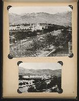
Photographs of Utah, including views in Salt Lake City of the City Hall, the interior of the Tabernacle, and Brigham Young's residence, and a portrait of Brigham Young. Outside of Salt Lake city there are photographs of a wagon train at Coalville, the Millersville Bridge, Weber Canyon, Soda Springs,and three composite photographs of Utah landscapes and Indians
Description:
Advertisement on verso of some mounts for C. W. Carter's Photograph Gallery and View Emporium. Manuscript captions on verso of some mounts. Letterpress captions on some mounts. One print of Brigham Young has become detached from its mount. and Accompanied by a box list.
Photographs of the homes and haunts of prominent Mormons in Illinois, Missouri and Utah, and of Salt Lake City and Saltair views, In Nauvoo, Illinois, views of the homes of Joseph Smith, Brigham Young, Lorenzo Snow and John Taylor and the grave of Joseph Smith, and of the jail in Carthage where Joseph and Hyram Smith were held, and the room in which they were killed. In Missouri, views of the jail at Liberty and of Lyman Wight's home at Adam-on-di-Aliman [?], near Gallatin, Missouri, and In Utah, views of the Tabernacle, Beehive houses, Eagle Gate, Temple Block, Assembly house, Court house, the grave of Brigham Young, and various street scenes in Salt Lake City. One photograph shows an advertisement for a baseball game between Salt Lake and Spokane. There are also views of the pavilion at Saltair Beach featuring bathers at Black Rock floating in the salt water, and of produce farming (beans, potatoes, onions) showing irrigated fields and water pipes
Description:
Individual prints are 9.6 x 12.8 cm. or smaller and are attached to both sides of large ledger pages. They are accompanied by manuscript captions and numbers. and The pages appear to constitute a proof book of photographs. See also WA Photos Folio 17 and WA Photos 1175.
Subject (Geographic):
Utah, Salt Lake City (Utah), Nauvoo (Ill.), and Carthage (Ill.)