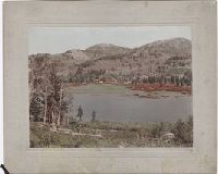
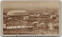
Photograph album of cabinet card views of Salt Lake City, Fort Douglas, Green River and Ogden, Utah, and studio portraits of Ute and Sioux Indians. Salt Lake City views include the Triumphal Arch, the Eagle Gate, the City and County Building, the Mormon Tabernacle under construction, Brigham Young's Schoolhouse, Brigham Young's grave, and the Old Curiosity Shop, and colored views of the Salt Air Palace, the City and County buiding, and the Brighton Hotel in Silver Lake, There are also portraits of Major John Gilbert, Joseph and Hyrum Smith, George Cannon, Heber J. Grant, and Brigham Young, and Most photographs are by C.R. Savage, with twelve images by Sainsbury & Johnson, one composite image showing stages in the construction of the Tabernacle by Chas. W. Carter, and a stereocard by Halsey & Coffin. Some cabinet cards are from the Bureau of Information and Church Literature of the Mormon Church
Description:
Cabinet cards, cartes-de-visite (1) and stereographs (5), many with advertisments on versos, some accompanied by manuscript captions. and Accompanied by a container list (in box 1).
Subject (Geographic):
Utah, Salt Lake City (Utah), Fort Douglas (Utah), Green River (Utah), and Ogden (Utah)
Subject (Topic):
Indians of North America, Ute Indians, Dakota Indians, and Mormons
Photographs of Arizona, New Mexico, Wyoming and Utah, including views of Santa Fe and Laguna and Taos Pueblos in New Mexico; the trolley lines in Uintah, Utah; winter views of the Grand Tetons in Wyoming; and an Ute Indian encampment in Los Pinos, New Mexico and There are also views of bridges and track along the line of the Union Pacific Railroad in Utah, the Atlantic and Pacific Railway Company bridge in Canon Diablo, Arizona, and Toltec Gorge, Arizona, along the line of the Denver & Rio Grand Railway
Description:
Accompanied by a box list. and Letterpress descriptions on verso of some mounts.
Publisher:
W. H. Jackson & Co., or W. H. & E. C. Jackson, Photographers
Subject (Geographic):
New Mexico., Santa Fe (N.M.), New Mexico, Uintah (Utah), Utah, Teton Range (Wyo. and Idaho), and Wyoming
Subject (Name):
Atlantic and Pacific Railway Company., Denver and Rio Grande Railroad Company., Union Pacific Railroad Company., and Chain & Hardy Book, Stationery & Art Co. (Denver, Colo.)
Subject (Topic):
Pueblo Indians, Indians of North America, Ute Indians, and Pueblos
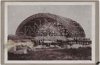
Photographs of Utah, including views in Salt Lake City of the City Hall, the interior of the Tabernacle, and Brigham Young's residence, and a portrait of Brigham Young. Outside of Salt Lake city there are photographs of a wagon train at Coalville, the Millersville Bridge, Weber Canyon, Soda Springs,and three composite photographs of Utah landscapes and Indians
Description:
Advertisement on verso of some mounts for C. W. Carter's Photograph Gallery and View Emporium. Manuscript captions on verso of some mounts. Letterpress captions on some mounts. One print of Brigham Young has become detached from its mount. and Accompanied by a box list.
Geographical Surveys West of the 100th Meridian (U.S.)
Published / Created:
1871-1874.
Call Number:
WA Photos Folio 55
Image Count:
68
Abstract:
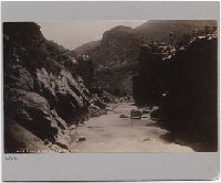
Album of mounted photographic prints created by Timothy H. O'Sullivan and William Bell, and later compiled by the United States War Department. Photographs document the Geographical Surveys West of the 100th Meridian led by George Montague Wheeler, 1871-1873, The photographic prints were arranged into three consecutive series by the United States War Department, "Explorations in Nevada and Arizona - Expedition of 1871," with photographs by O'Sullivan; "Explorations & Surveys West of the 100th Meridian - Expedition of 1872," with photographs by Bell; and "Geographical & Geological Explorations West of the 100th Meridian - Expedition of 1873," with photographs by O'Sullivan, Images of the expedition of 1871 by O'Sullivan include locations along the Colorado River in the Black Canyon, Iceberg Canyon, and Grand Canyon between Arizona and Nevada. Other images include a view of men and women in the mining town of Logan, Nevada; a view of Saguaro cacti, probably in the upper Sonoran desert in southern Arizona; a detailed view of a rock marked with striations from wind erosion near Grand Wash, Utah (misidentified by a typescript caption as below Fortification Rock, Arizona); and a view of an alpine lake, in the Sierra Nevada mountains in California, Images of the expedition of 1872 by Bell include views of steep rock walls and narrow valleys in vicinity of Kanab Canyon, Arizona, as well as views of the Colorado River and Marble Canyon (identified as Grand Cañon) near the confluence with the Paria River in Arizona. Other images include a view of geologic rock formations in Salt Creek Canyon, Utah, and Perched Rock near Rocker Creek, Arizona, Images of the expedition of 1873 by O'Sullivan in Arizona include views in the vicinity of the White Mountains with several views of Apache Lake, including an image that shows Western Apache Indian military scouts, as well as a view of the ranch owned by Corydon Eliphalet Cooley. Several images in the vicinity of Canyon de Chelly include views of the White House and Anasazi ruins, as well as images of rock towers and canyon walls. Other images include a view at the confluence of the Colorado River and Paria River; a view of the North Fork Canyon and the White River (identified as Sierra Blanca Creek); and an overview of Fort Apache, Images of the expedition of 1873 by O'Sullivan in New Mexico include images related to Inscription Rock, with a view of the steep rock spires and detail photographs of Spanish inscriptions carved in sandstone. Images of the community of Zuni, include a view of the Nuestra Señora de Guadalupe mission church, as well as views of multi-story stone and adobe pueblos. An image shows a view of an entrance or narthex of the Mission of San Miguel in Santa Fe. An informal portrait near Fort Defiance shows Navajo men and women sitting and standing beside a loom, and An incidental image from the expedition of 1873 by O'Sullivan in Utah shows a view of mesa tops and canyon walls near the confluence of the San Juan River and the Colorado River
Description:
Copy of album in WA MSS S-744 described in finding aid for collection., Each photograph accompanied by guard sheet with descriptive letter-press. Letterpress captions on mounts: War Department Corps of engineers. U.S. army . . . Lieut. Geo. M. Wheeler, Com'd'g., and Photographs by Timothy O'Sullivan for the 1871 expedition to Nevada and Arizona, numbered 1 through 16; photographs by William Bell for the 1872 expedition along the Colorado River and the Grand Canyon, numbered 1 through 15; and photographs by O'Sullivan for the 1873 expedition to Arizona and New Mexico, numbered 1 through 19.
Subject (Geographic):
Apache Lake (Ariz.), Arizona, Black Canyon (Ariz. and Nev.), Bull Run Mountains (Nev.), Canyon de Chelly National Monument (Ariz.), Colorado River (Colo.-Mexico), El Morro National Monument (N.M.), Fort Apache (Ariz.), Fort Defiance (N.M.), Grand Canyon (Ariz.), Iceberg Canyon (Ariz. and Nev.), Inscription Rock (N.M.), Kanab Canyon (Ariz.), Logan (Nev.), Marble Canyon (Coconino County, Ariz. : Canyon), Nevada, New Mexico, North Fork Canyon (Ariz.), Paria River (Utah and Ariz.), Salt Creek Canyon (Utah), San Juan River (Colo.-Utah), Sierra Nevada (Calif. and Nev.), Southwest, New, United States, Utah, West (U.S.), White Mountains (Ariz.), White River (Nev.), and Zuni (N.M.)
Subject (Name):
Bell, William, 1830-1910., Cooley, Corydon Eliphalet, O'Sullivan, Timothy H., 1840-1882, Mission San Miguel (Santa Fe, N.M.), Nuestra Señora de Guadalupe (Mission : Zuni, N.M.), Geographical Surveys West of the 100th Meridian (U.S.), and United States. War Department.
Subject (Topic):
Homes & haunts, Indians of North America, Navajo Indians, Paiute Indians, Pueblo Indians, Pueblos, Saguaro, Western Apache Indians, Exploring expeditions, and Surveys