Skip to search
Skip to main content
Skip to first result
Search
You Searched For
Subject Heading
Western Hemisphere > Maps > Early works to 1800
Search Results
Creator:
Published / Created:
1680.
Call Number:
1973 Folio 10
Image Count:
1
Alternative Title:
Map of all the world in two hemispheres in which are exactly described all the parts of the earth and seas
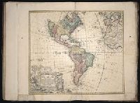
Description:
BEIN 1973 Folio 10: Bookplate of José M. Rodriguez. No. 1 of 63 maps bound together.
Publisher:
Sold by William Berry at ye sign of the globe between Charing-Cross and White-Hall
Subject (Geographic):
Western Hemisphere and Eastern Hemisphere
Subject (Topic):
World maps
Found in:
Beinecke Rare Book and Manuscript Library > A mapp of all the world in two hemispheres in which are exactly described all the parts of the earth and seas
Creator:
Published / Created:
1786.
Call Number:
1982 Folio 10
Image Count:
2
Description:
BEIN 1982 Folio 10: Not mounted on linen. 102 x 117 cm, on sheets 55 x 64 cm. Armorial bookplate: Charles Abbot. No. 38 of 42 maps bound together.
Publisher:
Printed for Robt. Sayer, map, chart & printseller
Subject (Geographic):
Western Hemisphere and United States
Found in:
Beinecke Rare Book and Manuscript Library > A new map of the whole continent of America : divided into North and South and West Indies wherein are exactly described the United States of North America as well as the several European possessions according to the preliminaries of peace signed at Versailles Jan. 20, 1783
Creator:
Published / Created:
MDCCXXXXVI [i.e., 1759]
Call Number:
1983 Folio 23
Image Count:
1
Description:
BEIN 70 1746D: Ms. numbers on right side of map. Sheet measures 48.5 x 55 cm. Cross Collection no. 132.
Publisher:
In lucem proferentibus Homannianis Heridibus
Subject (Geographic):
Western Hemisphere and America
Found in:
Beinecke Rare Book and Manuscript Library > Americae mappa generalis : secundum legitimas projectionis stereographicae regulas, relationesque recentissimas et observationes sociorum Acad. reg. sc. quae Parisiis est aliorumque auctorum nec non secundum mentem D.I.M. Hasii ; M.P.P. in partes suas methodicas divisa
Published / Created:
1596]
Call Number:
Taylor 192 4-6
Image Count:
15
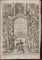
Alternative Title:
America. pars 6
Description:
BEIN Taylor 192 6: Blank leaf ²G6 wanting. Map: America siue nouus orbis respectu Europaeorum inferior globi terrestris pars 1596 (30 cm in diameter, on sheet 33 x 42 cm) bound following t.p. Plate: Cusco urbis nobilissima & opule[n]tissima Peruani r...
Publisher:
Theodore de Bry
Subject (Geographic):
Peru, America, Canary Islands, Florida, and Western Hemisphere
Subject (Topic):
History and Description and travel
Found in:
Beinecke Rare Book and Manuscript Library > Americae pars sexta, sive, Historiae ab Hieronymo Be[n]zono Mediolane[n]se scriptae, sectio tertia, res no[n]minus nobiles & admiratione plenas cintiens, quàm praecedentes duae : in hac enim reperies, qua ratione Hispani opule[n]tissimas illas Peruäni regni provincias occuparint, capto rege Atabaliba dei[n]de orta inter ipsos Hispanos in eo regno civilia bella : additus est brevis de Fortunatis insulis co[m]mentariolus in duo capita distinctus : idem ad ditiones ad singula capita historiam illustrantes : accessit Perväni regni chorographica tabula ... omnia figuris in aes incisis expressa à Theodoro de Bry Leod. cive. autem Fra[n]cofurte[n]se. a[nn]o MDXCVI
Creator:
Published / Created:
[1691]
Call Number:
70 169XA
Image Count:
1
Resource Type:
cartographic image
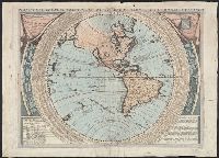
Description:
BEIN 70 169XA: Hand colored.
Publisher:
Vincenzo Coronelli
Subject (Geographic):
Western Hemisphere
Found in:
Beinecke Rare Book and Manuscript Library > Planisfero del mondo nuovo