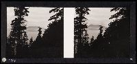
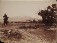
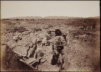
Album of Houseworth photographs of California presented by Edward Vischer to John Prince-Smith. Photographs depict San Francisco, Sacramento, and Stockton, Yosemite, dry dock at Hunter's Point, the Monitor Comanche, and the sinking of the Aquila carrying the Comanche, the Mendocino lumber region, geysers in Sonoma County, the Calaveras mammoth tree groves, scenes in the Sierra Nevada, including Lake Tahoe, and views of the Central Pacific Railroad
Description:
Thomas Houseworth (1829-1915) established his San Francisco photographic studio in the mid-1860s. Photographers who worked for Houseworth include George Fiske, Charles L. Weed, and Martin M. Hazeltine., John Prince-Smith was a German political economist, the founder and leader of the German Free Trade Party., Edward Vischer was a pioneer merchant and artist in early California., Printed title page continues "This selection of Houseworth & Co.'s Photographic Views to John Prince Smith, Dedicated by Edward Vischer.", Manuscript captions on mounts, with manuscript numbers on the prints., and Gilt lettering on front cover: California John Prince-Smith.
Publisher:
Houseworth & Co.
Subject (Geographic):
San Francisco Bay Area (Calif.), Sacramento (Calif.), Sierra Nevada (Calif. and Nev.), Tahoe, Lake (Calif. and Nev.), Yosemite National Park (Calif.), California, Sonoma County, Stockton (Calif.), and Calaveras County (Calif.)
Subject (Name):
Vischer, Edward., Central Pacific Railroad Company, Hunters Point Naval Shipyard, Comanche (Ironclad), and Aquila (Ship)
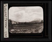
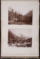
Stereoscopic slides, lantern slides, and two photograph albums recording the Burgermeisters' treks through the national parks of California and Washington. Views are of Yosemite National Park, Kings Canyon National Park, Sequoia National Park, and Mount Rainier National Park. A few of the photographs are of campsites and the Burgermeisters themselves. Accompanied by a stereoscope slide viewer made in Dresden, Germany
Description:
Emil Burgermeister, mountaineer, who with his wife Fanny trekked through the national parks and forests of California, Oregon, and Washington from the 1910s through the early 1930s., Accompanied by a container list., Albums, slides, and viewer stored in 6 boxes., Some slides captioned, all views identified after the Burgermeister's death by Oliver Kehrlein, a mountaineer-photographer., and Photograph albums labeled "B" and "C". List for album "A" created by Oliver Kehrlein in 1957, but album not present at time of acquisition.
Subject (Geographic):
West (U.S.), Kings Canyon National Park (Calif.), Mount Rainier National Park (Wash.), Sequoia National Park (Calif.), Whitney, Mount, Region (Calif.), and Yosemite National Park (Calif.)
Subject (Name):
Burgermeister, Emil, 1874-1957. and Burgermeister, Frances, 1881-1942.
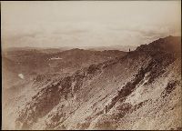
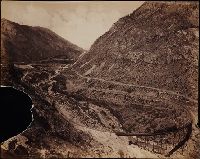
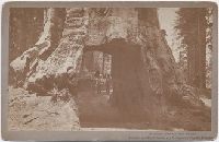
Photographs created from mammoth plate negatives primarily by photographers Carleton E. Watkins and William Henry Jackson of various locations in the American West, primarily in the states of California, Colorado, and Oregon, as well as Arizona, Montana, Utah, Washington, and Wyoming Territories, ca. 1874-1898, Photographs by Watkins consist of images created in the states of California and Oregon, and in Arizona, Montana, Utah, Washington, and Wyoming Territories, ca. 1874-1890, An image created by Watkins of Tombstone, Arizona Territory shows the Old South Shaft Ore Quarry of the Tough Nut Mine with a view of the town, the Dragoon Mountains, and the Cochise Stronghold in the distance, 1880, Images created by Watkins in California consist primarily of locations in Yosemite National Park, including Half Dome, Sentinel Rock, Tutocanula Pass (consisting of El Capitan and Cathedral Rocks cliff), and views of the Yosemite Valley from the Mariposa Trail and Eagle Point, 1878-1881. Other images from California include two different views from the top of Round Top Mountain, with one of the images showing a view of the Blue Lakes and the other the Mokelumne River, 1879; views in the vicinity of San Gabriel showing residences and wine houses of the Lake Vineyard, near the Sierra Madre Mountains and a date palm tree on the grounds of the Mission San Gabriel Arcangel, ca. 1874-1880; a view of the Carmel Valley from the Mission Road, Monterey; and a view of a waterfall, probably the Palisades Falls on the North Fork American River at Soda Springs, ca. 1874-1880, Images created by Watkins in Marysville, Montana Territory, consist of a view of the town, three interior views of a mill, and a view of the Drumlummon Mine and the Maskelyne Tunnel, 1884-1885 or 1890, Images created by Watkins along the Columbia River, Oregon, consist of views of rock bluffs along the river, a Native American village located at the Dalles, a winter view of the river with snow-covered shores, and a view of the Tooth Bridge and Eagle Creek Crossing, 1884-1885, Images created by Watkins in Washington Territory include a view of the Spokane Falls of the Spokane River, a mill in Port Ludlow, and ships at a dock in Port Madison on Bainbridge Island, 1882, Images created by Watkins of geothermal features in Yellowstone National Park, Wyoming Territory, consist of Giant Geyser, Grotto Geyser, Old Faithful Geyser, and Pulpit Terrace, 1884-1885, A majority of the images created by William Henry Jackson depict locations and geological features in Colorado, while other images show locations in Utah, Idaho, New Mexico, and Oregon, 1878-1898, Images from El Paso County, Colorado, created by Jackson include geological features in the Garden of the Gods, such as Cathedral Spires, Gate Rock, Tower of Babel, and the abutting Seal Rock and Bear Rock, with many images showing Pikes Peak in the distance; a view of Monument Park showing eroded sandstone rock formations; a view of a waterfall identified as Castle Falls, on North Cheyenne Creek in North Cheyenne Canyon; a view of Phoebe's Arch, near Palmer Lake; a view of Sheltered Falls on Ruxton Creek; a view of foothills and snow on Pikes Peak and Austin Bluffs; a view of Seven Falls (also known as Cheyenne Falls) on South Cheyenne Creek in South Cheyenne Canyon, and a view of Fountain Creek near Colorado City with a snow-covered Pikes Peak in the distance, Images from Gunnison County, Colorado, created by Jackson include a view of the Curecanti Needle rock formation in the Black Canyon with the Gunnison River and the railroad of the Denver and Rio Grande Railroad Company, and a view of a man standing on a rock by the Gunnison River near Sapinero, Two images in the Royal Gorge, Fremont County, Colorado, created by Jackson show the Denver and Rio Grande Railroad near the Arkansas River, with one of the images showing a suspension bridge known as Hanging Bridge, Other images created by Jackson in Colorado include a view of the city of Glenwood Springs in Garfield County and the stone and wood frame buildings at the Yampah Hot Springs bathhouse and pool; a view of the Georgetown Loop and tracks of the Colorado Central Railroad Company in Clear Creek Canyon in Clear Creek County; a view of Cathedral Spires and the Platte Canyon of the South Platte River with tracks of the Denver, South Park, and Pacific Railroad Company in Jefferson County; a view of people sitting in a horse-drawn carriage on a dirt road in Ute Pass, showing Twin Creek and Rainbow Falls, in Teller County; and a view of Sierra Blanca mountains, a stream and railroad tracks, possibly in Costilla County, Images created by Jackson in Utah include a view of Bridal Veil Falls on the Provo River in Provo Canyon, Utah County; and a view in the vicinity of Echo, depicting men standing and sitting on a rock formation identified as Pulpit Rock, Summit County, Other images created by Jackson include a view of the Twin Falls waterfall on the Snake River, Jerome County, Idaho; a view of Rio de los Pinos and rock formations in the Toltec Gorge, Rio Arriba County, New Mexico; and a view of Multnomah Falls on Multnomah Creek in Multnomah County, Oregon, and The collection includes an additional view created by F. Jay Haynes that shows an unidentified body of water beside two railroad tracks and a telegraph line; and an image probably by Watkins or Haynes that depicts an interior view of large industrial machinery in a brick building
Description:
A mammoth plate is a photographic negative plate, 18 by 21 inches (53.5 x 45.7 cm.) or larger, from which photographic prints are made through contact printing., Title devised by cataloger., Captions inscribed in the negatives created by Jackson., Manuscript inscription on the recto and verso of several photographic prints., and Photographs previously bound in a volume with the spine title "Photographs by Ezra Meeker and W. H. Jackson." The original boards and spine are filed with the collection.
Subject (Geographic):
Wyoming, Montana, West (U.S.), Arizona, Arkansas River, Austin Bluffs (Colo.), Black Canyon of the Gunnison (Colo.), Blue Lakes (Calif.), Bridal Veil Falls (Utah), California, Cathedral Rocks (Calif.), Cathedral Spires (El Paso County, Colo.), Cathedral Spires (Jefferson County, Colo.), Clear Creek Canyon (Colo.), Clear Creek County (Colo.), Cochise Stronghold (Ariz.), Colorado, Columbia River, Costilla County (Colo.), Curecanti Needle (Colo.), Dalles (Or.), Dragoon Mountains (Ariz.), Drumlummon Mine (Mont.), Eagle Creek (Or.), Echo (Utah), El Capitan (Calif.), El Paso County (Colo.), Fountain Creek (Colo.), Fremont County (Colo.), Garden of the Gods (Colorado Springs, Colo.), Garfield County (Colo.), Gate Rock (El Paso County, Colo.), Giant Geyser (Wyo.), Glenwood Springs (Colo.), Grotto Geyser (Wyo.), Gunnison County (Colo.), Gunnison River (Colo.), Half Dome (Calif.), Jefferson County (Colo.), Jerome County (Idaho), Lake Vineyard (San Gabriel, Calif.), Marysville (Lewis and Clark County, Mont.), Mokelumne River (Calif.), Monument Park (El Paso County, Colo.), Multnomah County (Or.), Multnomah Creek (Or.), Multnomah Falls (Or.), North Cheyenne Canyon (Colo.), North Cheyenne Creek (Colo.), North Fork American River (Calif.), Old Faithful Geyser (Wyo.), Oregon, Palisades Falls, Pikes Peak (Colo.), Platte Canyon (Colo.), Port Ludlow (Wash.), Port Madison (Bainbridge Island, Wash.), Provo Canyon (Utah), Provo River (Utah), Pulpit Rock (Utah), Pulpit Terrace (Wyo.), Rainbow Falls (Colo.), Rio Arriba County (N.M.), Rio de los Pinos (Colo. and N.M.), Round Top Mountain (Calif.), Royal Gorge (Colo.), San Gabriel (Calif.), Sentinel Rock (Calif.), Seven Falls (Colo.), Sierra Blanca (Colo.), Snake River (Wyo.-Wash.), Soda Springs (Calif.), South Cheyenne Canyon (Colo.), South Cheyenne Creek (Colo.), South Platte River (Colo. and Neb.), Spokane (Wash.), Spokane River (Idaho and Wash.), Teller County (Colo.), Toltec Gorge (N.M.), Tombstone (Ariz.), Tombstone Region (Ariz.), Twin Creek (Colo.), Twin Falls (Idaho : Waterfalls), Utah, Ute Pass (Teller County, Colo.), Washington (State), Yampah Hot Springs (Colo.), Yellowstone National Park, Yosemite National Park (Calif.), and Yosemite Valley (Calif.)
Subject (Name):
Haynes, F. Jay 1853-1921. (Frank Jay),, Jackson, William Henry, 1843-1942., Meeker, Ezra, 1830-1928., Watkins, Carleton E., 1829-1916., Colorado Central Railroad Company, Denver and Rio Grande Railroad Company, Denver, South Park, and Pacific Railroad Company, Mission San Gabriel Arcangel (San Gabriel, Calif.), and Tough Nut Mine
Subject (Topic):
Geysers, Landscape photography, Mineral industries, and Railroads
Photographs of Niagara Falls; Yosemite National Park, Shasta Springs, and the Siskiyou Mountains in California; Portland, Oregon; and Bow Falls in Banff, the Selkirk mountains, the Great Glacier, and other scenes along the Canadian Pacific Railway. Includes one image of the ruins of Pompeii, and one of other, unidentified ruins. Also includes a photograph of a drawing of Cunard's Atlantic liner "Umbria". and Photographers include Isaiah Taber of San Francisco; J. Thompson of New Westminster, B.C.; Wm. Notman & Son of Montreal; and G. Sommer of Naples, Italy
Description:
Photographer's captions printed in the negative for most images. and Label inside back cover: "A & N*C*S*Ld., Stationery Dept., 105 Victoria St. S.W."
Subject (Geographic):
Yosemite National Park (Calif.), Shasta Springs (Calif.), Siskiyou Mountains (Calif. and Or.), California, Portland (Or.), Oregon, Banff (Alta.), Selkirk Range, British Columbia, Alberta, Niagara Falls (N.Y. and Ont.), and Pompeii (Extinct city)
Subject (Name):
Taber, I. W. 1830-1912. (Isaiah West),, J. Thompson (Firm), Wm. Notman & Son., Canadian Pacific Railway Company, and Umbria (Steamship)
Photographs of California, Oregon, and Arizona, including views in San Francisco of the Palace Hotel, the residence of Mrs. Mark Hopkins, Golden Gate Park, Cliff House, Sutro Heights, the Seal Rocks, and the New City Hall, and views of Lake Tahoe, Santa Monica, Monterey, and San Gabriel. In Yosemite, the Nevada Fall, the Cathedral Rocks and Spires, Half Dome, and the Upper Geyser Basin are all depicted. Views in Oregon and Arizona include Indian Block Houses on the Upper Cascades of the Columbia River, and a desert scene with a group of cacti
Description:
Accompanied by a box list. and Advertisement on verso of some mounts for Watkins' Portrait and Landscape Photography. Manuscript captions on verso of some mounts.
Publisher:
Watkins
Subject (Geographic):
Yosemite National Park (Calif.), San Francisco (Calif.), California, and Columbia River