Search
You Searched For
Search Results
- Creator:
- Harrison, John, fl. 1784-1792
- Published / Created:
- 1791?]
- Call Number:
- 71 1791
- Container / Volume:
- BRBL_00367
- Image Count:
- 1
- Resource Type:
- Maps, Atlases & Globes
- Found in:
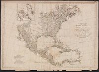
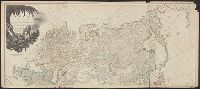
- Beinecke Rare Book and Manuscript Library > A map of North America : published under the patronage of the Duke of Orleans by d'Anville / drawn and engraved for J. Harrison, No. 115 Newgate Street, January 1, 1791.
- Creator:
- Sayer, Robert, 1725-1794
- Published / Created:
- July the 1st, 1787.
- Call Number:
- 90 1787
- Container / Volume:
- BRBL_00661
- Image Count:
- 2
- Resource Type:
- Maps, Atlases & Globes
- Found in:
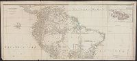
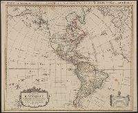
- Beinecke Rare Book and Manuscript Library > A map of South America : containing Tierra-Firma, Guayana, New Granada, Amazonia, Brasil, Peru, Paraguay, Chaco, Tucuman, Chili and Patagonia : from Mr. d'Anville with several improvements and additions, and the newest discoveries.
- Creator:
- Delarochette, L. (Louis), 1731-1802
- Published / Created:
- 17--?]
- Call Number:
- 70 1770
- Container / Volume:
- BRBL_00356
- Image Count:
- 1
- Resource Type:
- Maps, Atlases & Globes
- Found in:
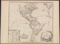
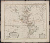
- Beinecke Rare Book and Manuscript Library > A map of the whole continent of America : according to D'Anville & Bellin / by L. Delarochette ; Bayly, sculpt.
- Creator:
- Kitchin, Thomas, d. 1784
- Published / Created:
- 1794
- Call Number:
- 40 1794
- Container / Volume:
- BRBL_00198
- Image Count:
- 1
- Resource Type:
- Maps, Atlases & Globes
- Found in:
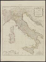
- Beinecke Rare Book and Manuscript Library > A new map of Italy with the islands of Sicily, Sardinia & Corsica / from Monsr. d'Anville: to which have been added the post roads and several other improvements.
- Creator:
- Sayer, Robert, 1725-1794
- Published / Created:
- [between 1750 and 1769?]
- Call Number:
- 71 1760C
- Container / Volume:
- BRBL_00364
- Image Count:
- 1
- Resource Type:
- Maps, Atlases & Globes
- Found in:
- Beinecke Rare Book and Manuscript Library > A new map of North America : with the British, French, Spanish, Dutch & Danish dominions on that great continent; and the West India Islands / done from the latest geographers, with great improvements from the Sieurs d'Anville & Robert.
- Creator:
- Homann Erben (Firm)
- Published / Created:
- 1756
- Call Number:
- 71 1756H
- Container / Volume:
- BRBL_00726
- Image Count:
- 1
- Resource Type:
- Maps, Atlases & Globes
- Found in:
- Beinecke Rare Book and Manuscript Library > America Septentrionalis a Domino d'Anville in Galliis edita nunc in Anglia : coloniis in interiorem Virginiam deductis nec non Fluvii Ohio cursu aucta notisque geographicis et historicis illustrata / sumptibus Homannianorum Heredum.
- Creator:
- Homann Erben (Firm)
- Published / Created:
- 1756
- Call Number:
- 755 1756B
- Container / Volume:
- BRBL_00428
- Image Count:
- 1
- Resource Type:
- Maps, Atlases & Globes
- Found in:
- Beinecke Rare Book and Manuscript Library > America Septentrionalis a Domino d'Anville in Galliis edita nunc in Anglia : coloniis in interiorem Virginiam deductis nec non Fluvii Ohio cursu aucta notisque geographicis et historicis illustrata / sumptibus Homannianorum Heredum.
- Creator:
- Homann Erben (Firm)
- Published / Created:
- 1756
- Call Number:
- 755 1756Ea
- Container / Volume:
- BRBL_00428
- Image Count:
- 1
- Resource Type:
- Maps, Atlases & Globes
- Found in:
- Beinecke Rare Book and Manuscript Library > America Septentrionalis a Domino d'Anville in Galliis edita nunc in Anglia : coloniis in interiorem Virginiam deductis nec non Fluvii Ohio cursu aucta notisque geographicis et historicis illustrata / sumptibus Homannianorum Heredum.
- Creator:
- Homann Erben (Firm)
- Published / Created:
- 1756
- Call Number:
- 755 1756G
- Container / Volume:
- BRBL_00690
- Image Count:
- 1
- Resource Type:
- Maps, Atlases & Globes
- Found in:
- Beinecke Rare Book and Manuscript Library > America Septentrionalis a Domino d'Anville in Galliis edita nunc in Anglia : coloniis in interiorem Virginiam deductis nec non Fluvii Ohio cursu aucta notisque geographicis et historicis illustrata / sumptibus Homannianorum Heredum.
- Creator:
- Homann Erben (Firm)
- Published / Created:
- 1777
- Call Number:
- 71 1777H
- Container / Volume:
- BRBL_00726
- Image Count:
- 1
- Resource Type:
- Maps, Atlases & Globes
- Found in:
- Beinecke Rare Book and Manuscript Library > America Septentrionalis a Domino d'Anville in Galliis edita nunc in Anglia : coloniis in interiorem Virginiam deductis nec non Fluvii Ohio cursu aucta notisque geographicis et historicis illustrata et ad bellum praesentis temporis accomodata / sumptibus H
- Creator:
- Kitchin, Thomas, d. 1784
- Published / Created:
- 6 Jany. 1787.
- Call Number:
- 50 1787
- Container / Volume:
- BRBL_00271
- Image Count:
- 2
- Resource Type:
- Maps, Atlases & Globes
- Found in:
- Beinecke Rare Book and Manuscript Library > Asia and its islands according to d'Anville : divided into empires, kingdoms, states, regions, & ca. with the European possessions and settlements in the East Indies and an exact delineation of all the discoveries made in the eastern parts by the English
- Creator:
- L'Isle, Guillaume de, 1675-1726
- Published / Created:
- 1774
- Call Number:
- 70 1774A
- Container / Volume:
- BRBL_00724
- Image Count:
- 1
- Resource Type:
- Maps, Atlases & Globes
- Found in:
- Beinecke Rare Book and Manuscript Library > Carte d'Amerique : divisées en ses principales parties / par G. Delisle, premier geographe du Roy, rectifiée apres les nouvelles observations du Sr. D'Anville et autres geographes ; J. Condet, sc.
- Creator:
- L'Isle, Guillaume de, 1675-1726
- Published / Created:
- 1774
- Call Number:
- 70 1774A
- Container / Volume:
- BRBL_00356
- Image Count:
- 1
- Resource Type:
- Maps, Atlases & Globes
- Found in:
- Beinecke Rare Book and Manuscript Library > Carte d'Amerique : divisées en ses principales parties / par G. Delisle, premier geographe du Roy, rectifiée apres les nouvelles observations du Sr. D'Anville et autres geographes ; J. Condet, sc.
- Creator:
- Homann Erben (Firm)
- Published / Created:
- 1743
- Call Number:
- 655 1743
- Container / Volume:
- BRBL_00345
- Image Count:
- 1
- Resource Type:
- Maps, Atlases & Globes
- Found in:
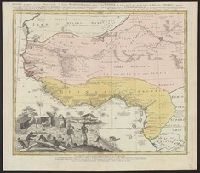
- Beinecke Rare Book and Manuscript Library > Gvinea propria, nec non Nigritiæ vel Terrae Nigrorvm maxima pars : geographis hodiernis dicta utraq[ue] Aethiopia inferior, & hujus quidem pars australis / ex delineationibus Anvillianis itineri guineensi D. de Marchais insertis secundum leges projectioni
- Creator:
- Berghaus, Heinrich Karl Wilhelm, 1797-1884
- Published / Created:
- 1843
- Call Number:
- 56 1843A
- Container / Volume:
- BRBL_00295
- Image Count:
- 1
- Resource Type:
- Maps, Atlases & Globes
- Found in:
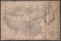
- Beinecke Rare Book and Manuscript Library > Karte von China und Japan den Manen D'Anville's und Klapproth's [cartographic material] / gewidmet Potsdam von H.B.
- Creator:
- Bolton, Solomon, d. ca. 1768
- Published / Created:
- 1766]
- Call Number:
- 71 1766B
- Container / Volume:
- BRBL_00364
- Image Count:
- 4
- Resource Type:
- Maps, Atlases & Globes
- Found in:
- Beinecke Rare Book and Manuscript Library > North America : performed under the patronage of Louis Duke of Orleans, First Prince of the Blood / by the Sieur d'Anville, greatly improved by Mr. Bolton ; engraved by R.W. Seale ; Gravelot, delin. ; Walker, sculp.
- Creator:
- Jefferys, Thomas, d. 1771
- Published / Created:
- May 1755.
- Call Number:
- 755 1755B
- Container / Volume:
- BRBL_00427
- Image Count:
- 1
- Resource Type:
- Maps, Atlases & Globes
- Found in:
- Beinecke Rare Book and Manuscript Library > North America from the French of Mr. D'Anville : improved with the back settlements of Virginia and course of Ohio : illustrated with geographical and historical remarks.
- Creator:
- Jefferys, Thomas, d. 1771
- Published / Created:
- August 12th, 1768.
- Call Number:
- 655 1768
- Container / Volume:
- BRBL_00345
- Image Count:
- 1
- Resource Type:
- Maps, Atlases & Globes
- Found in:
- Beinecke Rare Book and Manuscript Library > The western coast of Africa, from Cape Blanco to Cape Virga, exhibiting Senegambia proper / by T. Jefferys.
- Creator:
- Jefferys, Thomas, d. 1771
- Published / Created:
- 1st January 1789.
- Call Number:
- 655 1789
- Container / Volume:
- BRBL_00345
- Image Count:
- 1
- Resource Type:
- Maps, Atlases & Globes
- Found in:
- Beinecke Rare Book and Manuscript Library > The western coast of Africa, from Cape Blanco to Cape Virga, exhibiting Senegambia proper / by T. Jefferys.
- Creator:
- Sayer, Robert, 1725-1794
- Published / Created:
- between 1783 and 1794?]
- Call Number:
- 71 1800
- Container / Volume:
- BRBL_00367
- Image Count:
- 1
- Resource Type:
- Maps, Atlases & Globes
- Found in:
- Beinecke Rare Book and Manuscript Library > [A new map of the whole continent of America : divided into North and South and West Indies ...]
- Creator:
- Sayer, Robert, 1725-1794
- Published / Created:
- between 1783 and 1794?]
- Call Number:
- 71 1800B
- Container / Volume:
- BRBL_00367
- Image Count:
- 1
- Resource Type:
- Maps, Atlases & Globes
- Found in:
- Beinecke Rare Book and Manuscript Library > [A new map of the whole continent of America : divided into North and South and West Indies ...]