Search
You Searched For
Search Results
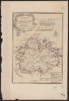
- Creator:
- Bowen, Emanuel, d. 1767
- Published / Created:
- 1747]
- Call Number:
- 8612 1747
- Container / Volume:
- BRBL_00696
- Image Count:
- 1
- Resource Type:
- Maps, Atlases & Globes
- Description:
- "No. 67" in lower left corner.
- Publisher:
- Printed for W. Innys, R. Ware ...,
- Subject (Geographic):
- Antigua--Maps--Early works to 1800
- Subject (Name):
- Bowen, Emanuel, d. 1767. A complete system of geography
- Subject (Topic):
- Nautical charts--Antigua--Early works to 1800
- Found in:
- Beinecke Rare Book and Manuscript Library > A new and accurate map of the island of Antigua or Antego [cartographic material] : taken from surveys, and adjusted by astronl. observations : containing all the towns, parish churches, forts, castles, windmills, roads &c. / by Eman. Bowen.
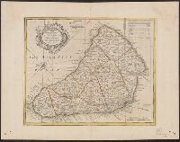
- Creator:
- Bowen, Emanuel, d. 1767
- Published / Created:
- 1747]
- Call Number:
- 867 1747
- Container / Volume:
- BRBL_00696
- Image Count:
- 1
- Resource Type:
- Maps, Atlases & Globes
- Description:
- "No. 69" in lower left corner.
- Publisher:
- Printed for W. Innys, R. Ware ...,
- Subject (Geographic):
- Barbados--Maps--Early works to 1800
- Subject (Name):
- Bowen, Emanuel, d. 1767. A complete system of geography
- Found in:
- Beinecke Rare Book and Manuscript Library > An accurate map of the island of Barbadoes [cartographic material] : drawn from an actual survey containing all the towns, churches, fortifications, roads, paths, plantations &c. / by Eman. Bowen.