Search
You Searched For
Search Results
- Creator:
- Evans, Lewis, 1700?-1756
- Published / Created:
- 1771
- Call Number:
- 755 1771B
- Container / Volume:
- BRBL_00429
- Image Count:
- 1
- Resource Type:
- Maps, Atlases & Globes
- Found in:
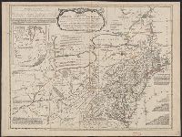
- Beinecke Rare Book and Manuscript Library > A general map of the middle British colonies in America, viz. Virginia, Maryland, Delaware, Pensilvania, New-Jersey, New York, Connecticut & Rhode Island: Of Aquanishuonigy the country of the confederate Indians comprehending Aquanishuonigy proper, their
- Creator:
- Delarochette, L. (Louis), 1731-1802
- Published / Created:
- [1769]
- Call Number:
- 40 1777
- Container / Volume:
- BRBL_00198
- Image Count:
- 1
- Resource Type:
- Maps, Atlases & Globes
- Found in:
- Beinecke Rare Book and Manuscript Library > A map of Italy / by Mr. Palairet with improvements & additions from the best authorities by L. Delarochette ; Tho Kitchin sculpt.
- Creator:
- Delarochette, L. (Louis), 1731-1802
- Published / Created:
- 1765
- Call Number:
- 71 1765
- Container / Volume:
- BRBL_00364
- Image Count:
- 1
- Resource Type:
- Maps, Atlases & Globes
- Found in:
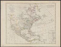
- Beinecke Rare Book and Manuscript Library > A map of North America / by J. Palairet, with considerable alterations & improvements from d'Anville, Mitchell & Bellin, by L. Delarochette.
- Creator:
- Bowen, Emanuel, 1693 or 1694-1767
- Published / Created:
- [1785?]
- Call Number:
- BrSides Double Folio 2019 91
- Image Count:
- 1
- Resource Type:
- Maps, Atlases & Globes
- Found in:
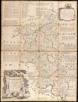
- Beinecke Rare Book and Manuscript Library > An accurate map of Buckingham Shire divided into its hundreds : drawn from the best authorities assisted by the most approved modern maps with various improvements. Illustrated with historical extracts relative to natural history, produce, trade and manufactures and the present state of the principal towns / by Eman. Bowen, Geogr. to His Majesty.
- Creator:
- Bowen, Emanuel, 1693 or 1694-1767
- Published / Created:
- [1785]
- Call Number:
- BrSides Double Folio 2019 90
- Image Count:
- 1
- Resource Type:
- Maps, Atlases & Globes
- Found in:
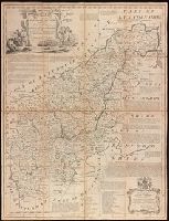
- Beinecke Rare Book and Manuscript Library > An accurate map of Northampton Shire divided into its hundreds : and laid down from the best authorities, assisted by the most approved modern maps, with various improvements, illustrated with historical extracts relative to its natural produce, trade, manufactures & present state of its principal towns / by Eman. Bowen Geogr. to His Majesty.
- Creator:
- Delarochette, L. (Louis), 1731-1802
- Published / Created:
- [ca. 1771]
- Call Number:
- 71 1771
- Container / Volume:
- BRBL_00365
- Image Count:
- 1
- Resource Type:
- Maps, Atlases & Globes
- Found in:
- Beinecke Rare Book and Manuscript Library > Bowles's new pocket map of North America : divided into its provinces, colonies, &c. / by J. Palairet, geographer ; lately revised and improved with many additions, from d'Anville, Mitchel, & Bellin, by L. Delarochette.
- Creator:
- Moll, Herman, d. 1732
- Published / Created:
- 17--]
- Call Number:
- 1978 47
- Collection Title:
- Atlas minor.
- Image Count:
- 1
- Found in:
- Beinecke Rare Book and Manuscript Library > The Island of St. Christophers By Her. Moll Geographer