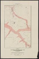
Search
You Searched For
Search Results
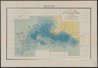
- Creator:
- Haanel, Eugene, 1841-1927
- Published / Created:
- 1905?]
- Call Number:
- 735gfc B418 1905
- Container / Volume:
- BRBL_00382
- Image Count:
- 1
- Resource Type:
- Maps, Atlases & Globes
- Found in:
- Beinecke Rare Book and Manuscript Library > Magnetic survey of the Belmont Iron Mine : lot 19, con. 1, Township of Belmont, County of Peterboro, Province of Ontario : map of the vertical intensity / Eugene Haanel, Superintendent of Mines ; surveyed by B.F. Haanel.
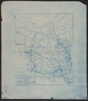
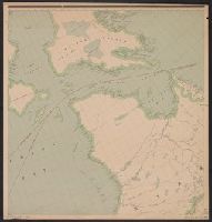
- Creator:
- Canada. Natural Resources Intelligence Branch
- Published / Created:
- [1922]
- Call Number:
- 735gb 1922
- Container / Volume:
- BRBL_00382
- Image Count:
- 1
- Resource Type:
- Maps, Atlases & Globes
- Found in:
- Beinecke Rare Book and Manuscript Library > Map of Algoma district, Ontario, showing natural resources / prepared in the Natural Resources Intelligence Branch, Department of the Interior.
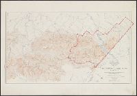
- Creator:
- Canada. Office of the Surveyor General
- Published / Created:
- 1918
- Call Number:
- 737 W31 1914
- Container / Volume:
- BRBL_00385
- Image Count:
- 1
- Resource Type:
- Maps, Atlases & Globes
- Found in:
- Beinecke Rare Book and Manuscript Library > Map of Waterton Lakes Park, Alberta [map] / from photographic surveys by M. P. Bridgland, D.L.S. and A. O. Wheeler, B.C.L.S. ; drawn and printed at the Surveyor General's Office.
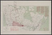
- Creator:
- White, James, 1863-1928
- Published / Created:
- [1908]
- Call Number:
- 73gck 1908
- Container / Volume:
- BRBL_00376
- Image Count:
- 1
- Resource Type:
- Maps, Atlases & Globes
- Found in:
- Beinecke Rare Book and Manuscript Library > Map of the Dominion of Canada / James White, F.R.G.S., Geographer.
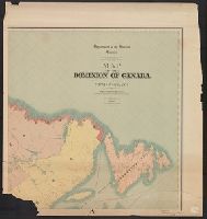
- Creator:
- White, James, 1863-1928
- Published / Created:
- 1904
- Call Number:
- 73gme 1904
- Container / Volume:
- BRBL_00376
- Image Count:
- 1
- Resource Type:
- Maps, Atlases & Globes
- Found in:
- Beinecke Rare Book and Manuscript Library > Map of the Dominion of Canada / James White, F.R.G.S., geographer.
- Creator:
- White, James, 1863-1928
- Published / Created:
- [1908]
- Call Number:
- 73 1908
- Container / Volume:
- BRBL_00375A
- Image Count:
- 1
- Resource Type:
- Maps, Atlases & Globes
- Found in:
- Beinecke Rare Book and Manuscript Library > Map of the Dominion of Canada / James White, geographer.
- Creator:
- Young, R. E
- Published / Created:
- 1910
- Call Number:
- 73gck 1910
- Container / Volume:
- BRBL_00376
- Image Count:
- 1
- Resource Type:
- Maps, Atlases & Globes
- Found in:
- Beinecke Rare Book and Manuscript Library > Map of the Dominion of Canada / R.E. Young, D.L.S., Chief Geographer.
- Creator:
- Young, R. E
- Published / Created:
- 1910
- Call Number:
- 73 1910
- Container / Volume:
- BRBL_00375A
- Image Count:
- 1
- Resource Type:
- Maps, Atlases & Globes
- Found in:
- Beinecke Rare Book and Manuscript Library > Map of the Dominion of Canada / R.E. Young, D.L.S., Chief Geographer.
- Creator:
- White, James, 1863-1928
- Published / Created:
- 1903
- Call Number:
- 73 1903
- Container / Volume:
- BRBL_00375
- Image Count:
- 8
- Resource Type:
- Maps, Atlases & Globes
- Found in:
- Beinecke Rare Book and Manuscript Library > Map of the Dominion of Canada and Newfoundland / James White, geographer.
- Creator:
- Geological and Natural History Survey of Canada
- Published / Created:
- [1886?]
- Call Number:
- 739GBC C19 1886G
- Container / Volume:
- BRBL_00392
- Image Count:
- 1
- Resource Type:
- Maps, Atlases & Globes
- Found in:
- Beinecke Rare Book and Manuscript Library > Quartz veins & placer mines of Little Snowshoe and Keithley Creeks, Cariboo District, British Columbia / surveyed and drawn by Amos Bowman, mining engineer, assisted by James McEvoy.
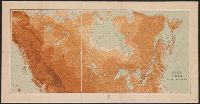
- Creator:
- White, James, 1863-1928
- Published / Created:
- 1904
- Call Number:
- 73cbf 1904
- Container / Volume:
- BRBL_00375A
- Image Count:
- 1
- Resource Type:
- Maps, Atlases & Globes
- Found in:
- Beinecke Rare Book and Manuscript Library > Relief map of the Dominion of Canada / James White, geographer.
- Creator:
- Geological and Natural History Survey of Canada
- Published / Created:
- [1886?]
- Call Number:
- 739GBC C19 1886H
- Container / Volume:
- BRBL_00392
- Image Count:
- 1
- Resource Type:
- Maps, Atlases & Globes
- Found in:
- Beinecke Rare Book and Manuscript Library > Veins & placer mines of Sugar Creek, Hardscrabble, Slough Creek, Nelson Creek, Willow River and Dragon Creek, Cariboo District, British Columbia / surveyed and drawn by Amos Bowman, assisted by James McEvoy.
- Published / Created:
- 1910?]
- Call Number:
- 73 1910A
- Container / Volume:
- BRBL_00375A
- Image Count:
- 3
- Resource Type:
- Maps, Atlases & Globes
- Found in:
- Beinecke Rare Book and Manuscript Library > [Map of Canada north of 60⁰].