1.
- Creator:
- Sayer, Robert, 1725-1794
- Published / Created:
- 1 Jan. 1788.
- Call Number:
- 734 1788
- Container / Volume:
- BRBL_00379
- Image Count:
- 1
- Resource Type:
- Maps, Atlases & Globes
- Alternative Title:
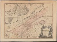
- Province of Quebec
- Description:
- Includes insets of "A particular survey of the Isles of Montreal" and "Course of the river St. Laurence, from La Valterie to Quebec," and indexed insets of "The city of Quebec" and "Plan of Montreal, or Víllemarie.", Relief shown pictorially., and Stamp of Wil
- Publisher:
- Printed for Robert Sayer, no. 53 Fleet Street,
- Subject (Geographic):
- Québec (Province)--Maps--Early works to 1800
- Subject (Name):
- Carver, Jonathan, 1710-1780 and Morse, William Inglis,--b. 1874--Stamp
- Found in:
- Beinecke Rare Book and Manuscript Library > A new and correct map of the Province of Quebec, with the adjacent states and provinces / from the French surveys connected with those made by Captain Carver, and other officers, in His Majesty's service.