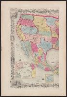
1. Map of the United States of America, the British provinces, Mexico, the West Indies, and Central Creator: Colton, G. Woolworth (George Woolworth), 1827-1901 Published / Created: 1854 Call Number: 71 1854B Container / Volume: BRBL_00371 Image Count: 2 Resource Type: Maps, Atlases & Globes Found in: Beinecke Rare Book and Manuscript Library > Map of the United States of America, the British provinces, Mexico, the West Indies, and Central America, with part of New Granada and Venezuela / map drawn by Geo. W. Colton ; engraved by John M. Atwood ; border desig'd. & eng'd. by W.S. Barnard.