Search
You Searched For
Search Results
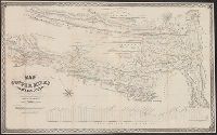
- Creator:
- Handy and Wallace
- Published / Created:
- 1864
- Call Number:
- 844gfc C128 1864
- Container / Volume:
- BRBL_00615
- Image Count:
- 1
- Resource Type:
- Maps, Atlases & Globes
- Found in:
- Beinecke Rare Book and Manuscript Library > Map of the copper mines of Calaveras County : from actual survey and measurement / surveyed and drawn by Handy and Wallace, civil engineers.
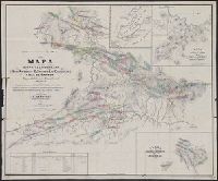
- Creator:
- Allardt, G. F. (George Frederick)
- Published / Created:
- 1863
- Call Number:
- 837gfc R25 1863
- Container / Volume:
- BRBL_00595
- Image Count:
- 1
- Resource Type:
- Maps, Atlases & Globes
- Found in:
- Beinecke Rare Book and Manuscript Library > Topographical map of the Reese River mines : located in the vicinity of the town of Austin, Lander County, N.T. / surveyed and drawn by G.F. Allardt ....
- Creator:
- Higginson & Goldsworthy
- Published / Created:
- [1865?]
- Call Number:
- 837gfc V81 1865
- Container / Volume:
- BRBL_00595
- Image Count:
- 1
- Resource Type:
- Maps, Atlases & Globes
- Found in:
- Beinecke Rare Book and Manuscript Library > Map of Virginia, Gold Hill, Devils Gate, American Flat gold & silver mining districts : state of Nevada / Higginson & Goldsworthy, civil & mining engineers ; W. Vallance Gray, lith.
- Creator:
- Cox, Gustavo
- Published / Created:
- 1865
- Call Number:
- 88192gfc 1865
- Container / Volume:
- BRBL_00653
- Image Count:
- 1
- Resource Type:
- Maps, Atlases & Globes
- Found in:
- Beinecke Rare Book and Manuscript Library > Mapa de los distritos minerales de San Antonio, El Triunfo, Las Cacachilas y Isla de Carmen : Baja California, República de México / recopilado y delineado por Don Gustavo Cox, ingeniero de minas.