Search
You Searched For
Search Results
- Creator:
- Selden, Henry S
- Published / Created:
- 1899
- Call Number:
- 80 1899
- Container / Volume:
- BRBL_00536
- Image Count:
- 1
- Resource Type:
- Maps, Atlases & Globes
- Found in:
- Beinecke Rare Book and Manuscript Library > Map of Texas and parts of adjoining territories / compiled by and under the direction of Robert T. Hill ; drawn by Henry S. Selden and Willard D. Johnson.
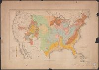
- Creator:
- McGee, W. J., 1853-1912
- Published / Created:
- 1884
- Call Number:
- 75CA 1884
- Container / Volume:
- BRBL_00407A
- Image Count:
- 1
- Resource Type:
- Maps, Atlases & Globes
- Found in:
- Beinecke Rare Book and Manuscript Library > Map of the United States exhibiting the present status of knowledge relating to the areal distribution of geologic groups : (preliminary compilation) / compiled by W.J. McGee.
- Creator:
- Appalachian Mountain Club
- Published / Created:
- 1890
- Call Number:
- 764 B65 1890A
- Container / Volume:
- BRBL_00456
- Image Count:
- 1
- Resource Type:
- Maps, Atlases & Globes
- Found in:
- Beinecke Rare Book and Manuscript Library > Map of the country about Boston / Geo. S. Harris & Sons, lith.
- Published / Created:
- 1883?]
- Call Number:
- 842 1883
- Container / Volume:
- BRBL_00598
- Image Count:
- 1
- Resource Type:
- Maps, Atlases & Globes
- Found in:
- Beinecke Rare Book and Manuscript Library > Northeastern Arizona / U.S. Geological Survey ; Henry Gannett, chief geographer ; A.H. Thompson, geographer in charge ; H.M. Wilson, topographer.
- Creator:
- Richardson, G. B
- Published / Created:
- 1921
- Call Number:
- 774gbc 1921
- Container / Volume:
- BRBL_00501A
- Image Count:
- 1
- Resource Type:
- Maps, Atlases & Globes
- Found in:
- Beinecke Rare Book and Manuscript Library > Oil and gas fields of Pennsylvania / compiled under the direction of G.B. Richardson.
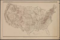
- Creator:
- United States. Department of Agriculture. Division of Publications
- Published / Created:
- 1910
- Call Number:
- 75fb 1910
- Container / Volume:
- BRBL_00410
- Image Count:
- 1
- Resource Type:
- Maps, Atlases & Globes
- Found in:
- Beinecke Rare Book and Manuscript Library > Outline map of the United States by counties / engraved and printed by the U.S. Geological Survey.
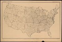
- Creator:
- United States. Department of Agriculture. Division of Publications
- Published / Created:
- 1915
- Call Number:
- 75eb 1910B
- Container / Volume:
- BRBL_00410
- Image Count:
- 1
- Resource Type:
- Maps, Atlases & Globes
- Found in:
- Beinecke Rare Book and Manuscript Library > Outline map of the United States by counties / engraved and printed by the U.S. Geological Survey.
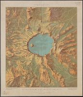
- Creator:
- Renshawe, J. H. (John Henry), 1852-
- Published / Created:
- [1914?]
- Call Number:
- 846am C855 1914
- Container / Volume:
- BRBL_00623
- Image Count:
- 1
- Resource Type:
- Maps, Atlases & Globes
- Found in:
- Beinecke Rare Book and Manuscript Library > Panoramic View of the Crater Lake National Park, Oregon / prepared by John H. Renshawe from topographic sheet of the United States Geological Survey.
- Creator:
- Renshawe, John H
- Published / Created:
- [1914?]
- Call Number:
- 831am G45 1920
- Container / Volume:
- BRBL_00581
- Image Count:
- 1
- Resource Type:
- Maps, Atlases & Globes
- Found in:
- Beinecke Rare Book and Manuscript Library > Panoramic view of the Glacier National Park, Montana / prepared by John H. Renshawe from topographic sheets of the United States Geological Survey ; engraved and printed by the United States Geological Survey.
- Creator:
- Renshawe, John H
- Published / Created:
- [1914]
- Call Number:
- 847am M864 1914
- Container / Volume:
- BRBL_00628
- Image Count:
- 1
- Resource Type:
- Maps, Atlases & Globes
- Found in:
- Beinecke Rare Book and Manuscript Library > Panoramic view of the Mount Rainier National Park, Washington / prepared by John H. Renshawe from topographic sheet of the United States Geological Survey.