Search
You Searched For
Search Results
- Creator:
- Senécal, C. O. (Clovis Omer)
- Published / Created:
- 1904
- Call Number:
- 734 M769 1904
- Container / Volume:
- BRBL_00380
- Image Count:
- 1
- Resource Type:
- Maps, Atlases & Globes
- Found in:
- Beinecke Rare Book and Manuscript Library > Map of the city of Montreal and vicinity : showing location of Wells to illustrate report of Frank D. Adams, 1904 / C.O. Senécal, geographer & chief draughtsman.
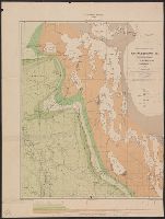
- Creator:
- Boyd, W. H
- Published / Created:
- 1906
- Call Number:
- 739ca R73 1906
- Container / Volume:
- BRBL_00391
- Image Count:
- 1
- Resource Type:
- Maps, Atlases & Globes
- Found in:
- Beinecke Rare Book and Manuscript Library > Sketch geological map of the city of Rossland and vicinity, B.C., showing mining claims [cartographic material] / compiled by W. H. Boyd ; approximate geological boundaries by G. H. Young.
- Creator:
- Boyd, Walter Halcro, 1878-
- Published / Created:
- 1908
- Call Number:
- 739 R73 1908
- Container / Volume:
- BRBL_00390
- Image Count:
- 1
- Resource Type:
- Maps, Atlases & Globes
- Found in:
- Beinecke Rare Book and Manuscript Library > Special map of Rossland, British Columbia / by W.H. Boyd.
- Creator:
- Eaton, Daniel Isaac Vernon
- Published / Created:
- 1896
- Call Number:
- 725CA 1896
- Container / Volume:
- BRBL_00373
- Image Count:
- 4
- Resource Type:
- Maps, Atlases & Globes
- Found in:
- Beinecke Rare Book and Manuscript Library > Map of Labrador Peninsula / compiled by D.I.V. Eaton ; drawn for photo-lithography by C.O. Senécal.
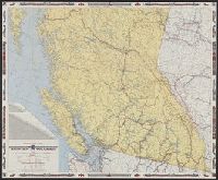
- Creator:
- British Columbia Government Travel Bureau
- Published / Created:
- 1954
- Call Number:
- 739 1954
- Container / Volume:
- BRBL_00389
- Image Count:
- 2
- Resource Type:
- Maps, Atlases & Globes
- Found in:
- Beinecke Rare Book and Manuscript Library > Highway and travel map of British Columbia / Basic map data by Geological Survey of Canada ; tourist information by Geographic Division, Surveys and Mapping Branch, Department of Lands and Forests.
- Creator:
- Senécal, C. O. (Clovis Omer)
- Published / Created:
- 1920
- Call Number:
- 7345 1920
- Container / Volume:
- BRBL_00381
- Image Count:
- 2
- Resource Type:
- Maps, Atlases & Globes
- Found in:
- Beinecke Rare Book and Manuscript Library > North Shore of the Gulf of St. Lawrence and adjoining territory, Saguenay County, Quebec / C.-O. Senécal, geographer and chief draughtsman.
- Creator:
- Ells, Robert Wheelock (1845-1911)
- Published / Created:
- 1884
- Call Number:
- 7311CA 1884
- Container / Volume:
- BRBL_00376A
- Image Count:
- 1
- Resource Type:
- Maps, Atlases & Globes
- Found in:
- Beinecke Rare Book and Manuscript Library > Part of New Brunswick and Prince Edward Island. no. 5 N.W. / Compiled and drawn by R.W. Ells... [et al.] ; Alfred R.C. Selwyn L.L.D., F.R.S. & director.
- Creator:
- Ells, Robert Wheelock (1845-1911)
- Published / Created:
- 1884
- Call Number:
- 7311CA 1884A
- Container / Volume:
- BRBL_00376A
- Image Count:
- 1
- Resource Type:
- Maps, Atlases & Globes
- Found in:
- Beinecke Rare Book and Manuscript Library > Prince Edward Island. no. 6 S.W. / Compiled and drawn by R.W. Ells... [et al.] ; Alfred R.C. Selwyn L.L.D., F.R.S. & director.
- Creator:
- Ells, Robert Wheelock (1845-1911)
- Published / Created:
- 1884
- Call Number:
- 7311CA 1884B
- Container / Volume:
- BRBL_00376A
- Image Count:
- 1
- Resource Type:
- Maps, Atlases & Globes
- Found in:
- Beinecke Rare Book and Manuscript Library > Prince Edward Island. no. 5 N.E. / Compiled and drawn by R.W. Ells... [et al.] ; Alfred R.C. Selwyn L.L.D., F.R.S. & director.
- Creator:
- Tyrrell, Joseph Burr, 1858-1957
- Published / Created:
- 1891
- Call Number:
- 736CA 1891
- Container / Volume:
- BRBL_00382
- Image Count:
- 1
- Resource Type:
- Maps, Atlases & Globes
- Found in:
- Beinecke Rare Book and Manuscript Library > Geological map of north western Manitoba and portions of the districts of Assiniboia and Saskatchewan [cartographic material] / by J. B. Tyrrell ; assisted by D. B. Dowling.