Search
You Searched For
Search Results
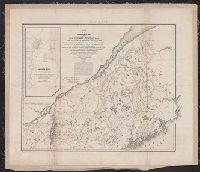
- Creator:
- United States. Army. Corps of Topographical Engineers
- Published / Created:
- 1843
- Call Number:
- 73fab 1843
- Container / Volume:
- BRBL_00375B
- Image Count:
- 1
- Resource Type:
- Maps, Atlases & Globes
- Found in:
- Beinecke Rare Book and Manuscript Library > Map of the boundary lines between the United States and the adjacent British provinces : from the mouth of the River St. Croix to the intersection of the parallel of 45 degrees of north latitude with the River St. Lawrence near St. Regis.
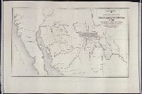
- Creator:
- Lee, Thomas Jefferson, 1808-1891
- Published / Created:
- 1842?]
- Call Number:
- 796fab Sa13 1842H
- Container / Volume:
- BRBL_00530
- Image Count:
- 5
- Resource Type:
- Maps, Atlases & Globes
- Found in:
- Beinecke Rare Book and Manuscript Library > Map of the river Sabine from its mouth on the Gulf of Mexico in the sea to Logan's Ferry in latitude 31⁰, 58', 24" north, shewing the boundary between the United States and the Republic of Texas between said points, as marked and laid down by survey in 18
- Published / Created:
- 1847
- Call Number:
- WA MSS S-1403
- Collection Title:
- J. D. Graham papers, 1804-1896
- Container / Volume:
- Folder 773
- Image Count:
- 1
- Found in:
- Beinecke Rare Book and Manuscript Library > Mexican Boundary B. Extract from the Treaty Map of Disturnell of 1847
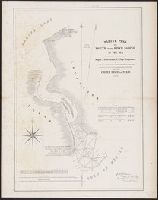
- Creator:
- Lee, Thomas Jefferson, 1808-1891
- Published / Created:
- 1842?]
- Call Number:
- 796fab Sa13 1842J
- Container / Volume:
- BRBL_00530
- Image Count:
- 1
- Resource Type:
- Maps, Atlases & Globes
- Found in:
- Beinecke Rare Book and Manuscript Library > Sabine Pass and mouth of the river Sabine in the sea / surveyed under the direction of Major J.D. Graham, U.S. Top.l Engineers ; by Lieut. T.J. Lee, U.S. Top.l Engineers and Cap.t P.J. Pillans, Texan Army, attached to the Joint Commission for marking the