Search
You Searched For
Search Results
- Creator:
- Hase, Johann Matthias, 1684-1742
- Published / Created:
- [ca. 1737]
- Call Number:
- 60 1737A
- Container / Volume:
- BRBL_00323
- Image Count:
- 1
- Resource Type:
- Maps, Atlases & Globes
- Found in:
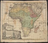
- Beinecke Rare Book and Manuscript Library > Africa secundum legitimas projectionis stereographicae regulas et juxta recentissimas relationes et observationes in subsidium vocatis quoque veterum Leonis Africani Nubiensis Geographi et aliorum monumentis et eleminatis fabulosis aliorum designationibus
- Creator:
- Hase, Johann Matthias, 1684-1742
- Published / Created:
- 1737
- Call Number:
- 60 1737
- Container / Volume:
- BRBL_00323
- Image Count:
- 1
- Resource Type:
- Maps, Atlases & Globes
- Found in:
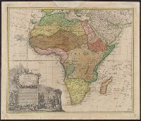
- Beinecke Rare Book and Manuscript Library > Africa secundum legitimas projectionis stereographicae regulas et juxta recentissimas relationes et observationes in subsidium vocatis quoque veterum Leonis Africani Nubiensis Geographi et aliorum monumentis et eleminatis fabulosis aliorum designationibus
- Creator:
- Mayer, Tobias, 1723-1762
- Call Number:
- BrSides Double Folio 2019 29
- Image Count:
- 1
- Resource Type:
- Maps, Atlases & Globes
- Found in:
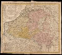
- Beinecke Rare Book and Manuscript Library > Belgivm Catholicvm seu decem provinciae Germaniae inferioris : cum confiniis Germaniae svp. et Franciae legitime omnia delineata et ad ductum observationum astronomicarum, nec non geometricarum operationum a Cassinio Snellio Muschenbrokio aliisqve rite ha
- Published / Created:
- 1743
- Call Number:
- 501 1743
- Container / Volume:
- BRBL_00275
- Image Count:
- 1
- Resource Type:
- Maps, Atlases & Globes
- Found in:
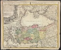
- Beinecke Rare Book and Manuscript Library > Carte de l'Asie Minevre ou de la Natolie et du Pont Evxin ... Par Sr. Has. P.P. imprimée aux depens des Heritiers de Homann.
- Published / Created:
- 1748
- Call Number:
- 556 1748
- Container / Volume:
- BRBL_00292
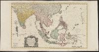
- Image Count:
- 2
- Resource Type:
- Maps, Atlases & Globes
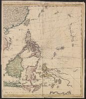
- Found in:
- Beinecke Rare Book and Manuscript Library > Carte des Indes Orientalis one feuille ... les Indes deca la Riviere de Ganges, le Golfe de Bengale, Siam, Malacca, Sumatra ... Par Mr. Tobie Mayer ... S. Dorn, Sc.
- Published / Created:
- 1748
- Call Number:
- 556 1748
- Container / Volume:
- BRBL_00292
- Image Count:
- 1
- Resource Type:
- Maps, Atlases & Globes
- Found in:
- Beinecke Rare Book and Manuscript Library > Carte des Indes Orientalis one feuille ... les Indes deca la Riviere de Ganges, le Golfe de Bengale, Siam, Malacca, Sumatra ... Par Mr. Tobie Mayer ... S. Dorn, Sc.
- Creator:
- Petit, Jean de
- Published / Created:
- [ca. 1730]
- Call Number:
- 399 1730
- Container / Volume:
- BRBL_00195
- Image Count:
- 1
- Resource Type:
- Maps, Atlases & Globes
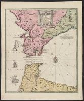
- Found in:
- Beinecke Rare Book and Manuscript Library > Carte nouvelle de l'Isle de Cadix et du Detroit de Gibraltar / leveè par Iean de Petit, cy devant Ingenieur & Architecte du Roy de France & dernierement Lieut. Colonel & Ingen. Ordin. de Sa Maj. Polonoise ; R.A. Schneider sculp. Fürth.
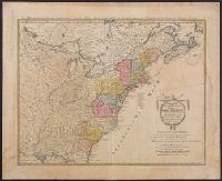
- Creator:
- Güssefeld, F. L. (Franz Ludwig), 1744-1807
- Published / Created:
- ao. 1784.
- Call Number:
- 755 1784A
- Container / Volume:
- BRBL_00435
- Image Count:
- 1
- Resource Type:
- Maps, Atlases & Globes
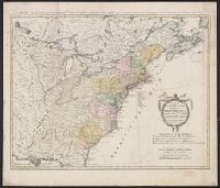
- Found in:
- Beinecke Rare Book and Manuscript Library > Charte über die XIII vereinigte Staaten von Nord-Amerika / entworfen durch F.L. Güssefeld und herausgegeben von den Homaennischen Erben.
- Creator:
- Güssefeld, F. L. (Franz Ludwig), 1744-1807
- Published / Created:
- ao. 1784.
- Call Number:
- 75 1784G
- Container / Volume:
- BRBL_00727
- Image Count:
- 1
- Resource Type:
- Maps, Atlases & Globes
- Found in:
- Beinecke Rare Book and Manuscript Library > Charte über die XIII vereinigte Staaten von Nord-Amerika / entworfen durch F.L. Güssefeld und herausgegeben von den Homaennischen Erben.
- Creator:
- Güssefeld, F. L. (Franz Ludwig), 1744-1807
- Published / Created:
- 1797
- Call Number:
- 71 1797
- Container / Volume:
- BRBL_00367
- Image Count:
- 1
- Resource Type:
- Maps, Atlases & Globes
- Found in:
- Beinecke Rare Book and Manuscript Library > Charte von Nordamerica : nach astronomischen Bestimmungen und den neuesten Charten von Dalrymple, Arrowshmit, Edwards, u.a.m. / neue entworfen von F.L. Güssefeld ; I. Rausch sc. Nürnb.
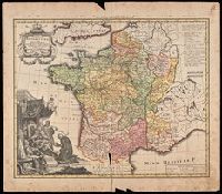
- Creator:
- Carl, Rupert
- Published / Created:
- [1738]
- Call Number:
- BrSides Double Folio 2019 41
- Image Count:
- 1
- Resource Type:
- Maps, Atlases & Globes
- Found in:
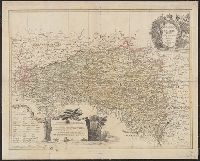
- Beinecke Rare Book and Manuscript Library > Gallia benedictina : La France benedictine : seu abbatiae & prioratus tam monachorum quam monialium ord. S. Benedicti. ibide[.] existe[n]tes iuxta exemplar parisiense / cura & opera p. Ruperti Carl, professi weiche[n]steph.
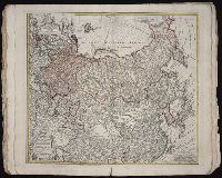
- Creator:
- Hase, Johann Matthias, 1684-1742, cartographer.
- Published / Created:
- 1739
- Call Number:
- 1975 Folio 31
- Collection Title:
- [Atlas factice of 42 maps, produced by the Homann Erben firm]
- Image Count:
- 1
- Resource Type:
- Maps, Atlases & Globes
- Found in:
- Beinecke Rare Book and Manuscript Library > Imperii Russici et Tatariae universae tam majoris et Asiaticae, qvam minoris et Europaeae tabvla / ex recentissimis et probatissimis monumentis et relationibus concin[n]ata, et ad legitimas projectionum geographic. regulas plane exacta opera Ioh Matthiae Hasii, Math. P.P. ... ; R.A. Schneider, sc.
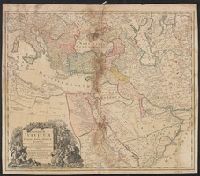
- Creator:
- Homann, Johann Baptist, 1663-1724
- Published / Created:
- 1737]
- Call Number:
- 501 1737A
- Container / Volume:
- BRBL_00275
- Image Count:
- 1
- Resource Type:
- Maps, Atlases & Globes
- Found in:
- Beinecke Rare Book and Manuscript Library > Imperium Turcicum in Europa, Asia et Africa regiones proprias, tributarias, clientelares sicut et omnes eusdem Beglirbegatus seu praefecturas generales exhibens / sumptibus Io. Baptista Hommani.
- Creator:
- Güssefeld, F. L. (Franz Ludwig), 1744-1807
- Published / Created:
- 1775
- Call Number:
- 41 G13 1775
- Container / Volume:
- BRBL_00242
- Image Count:
- 1
- Resource Type:
- Maps, Atlases & Globes
- Found in:
- Beinecke Rare Book and Manuscript Library > Lubomeriae et Galliciae regni tabula geographica / [cartographic material] / F.I.G.
- Creator:
- Homann, Johann Baptist, 1663-1724
- Published / Created:
- [1707?]
- Call Number:
- BrSides Double Folio 2019 30
- Image Count:
- 1
- Resource Type:
- Maps, Atlases & Globes
- Found in:
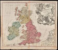
- Beinecke Rare Book and Manuscript Library > Magna Britannia complectens Angliae, Scotiae et Hiberniae Regna in suas provincias et comitatus divisa repraesentate / Io. Bapt. Homann.
- Creator:
- Mayer, Tobias, 1723-1762
- Published / Created:
- 1773
- Call Number:
- 356 1773
- Container / Volume:
- BRBL_00113
- Image Count:
- 1
- Resource Type:
- Maps, Atlases & Globes
- Found in:
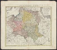
- Beinecke Rare Book and Manuscript Library > Mappa geographica Regni Poloniae : ex novissimis quotquot sunt mappis specialibus composita et ad L.L. stereographica projectionis / revocata a Tob. Mayero, S.C.S.
- Creator:
- Mayer, Tobias, 1723-1762
- Published / Created:
- [after 1772]
- Call Number:
- BrSides Double Folio 2019 28
- Image Count:
- 1
- Resource Type:
- Maps, Atlases & Globes
- Found in:
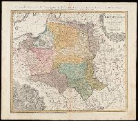
- Beinecke Rare Book and Manuscript Library > Mappa geographica Regni Poloniae : ex novissimis quotquot sunt mappis specialibus composita et ad L.L. stereographica projectionis / revocata à Tob. Mayero.
- Published / Created:
- ca. 1750]
- Call Number:
- 85 1740C
- Container / Volume:
- BRBL_00693
- Image Count:
- 1
- Resource Type:
- Maps, Atlases & Globes
- Found in:
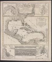
- Beinecke Rare Book and Manuscript Library > Mappa geographica, complectens : I. Indiae Occidentalis partem mediam circum Isthmum Panamensem, II. Ipsumq[ue] Isthmum, III. Ichnographiam praecipuorum locorum & portuum ad has terras pertinentium. Desumta omnia ex historia Insulae S. Dominici & pro prae
- Creator:
- Doppelmayr, Johann Gabriel, 1677-1750
- Published / Created:
- 1740
- Call Number:
- 5 1740
- Container / Volume:
- BRBL_00271
- Image Count:
- 1
- Resource Type:
- Maps, Atlases & Globes
- Found in:
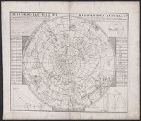
- Beinecke Rare Book and Manuscript Library > Motus cometarum in hemisphaerio australi : qui intra an[n]um 1530 et 1740 cum duabus stellis novis, nostra tempore visis, à celeberrimis astronomis observati, geometrice nunc descripti / à Ioh. Gabr. Doppelmaiero ...
- Published / Created:
- Ao. 1733.
- Call Number:
- 399AM 1733
- Container / Volume:
- BRBL_00195
- Image Count:
- 1
- Resource Type:
- Maps, Atlases & Globes
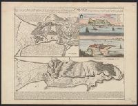
- Found in:
- Beinecke Rare Book and Manuscript Library > Neuester und exacter Plan und Prospect von der Stadt, Vestung, Bay und Fortification von Gibraltar ...