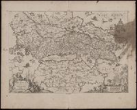
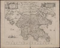
Achaiae noua & accurata descriptio and Achaiae nova et accurata descriptio
Description:
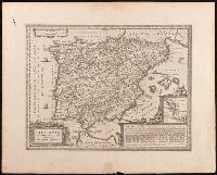
Coordinates not present on map and are approximated., Includes four bar scales., Manuscript number in upper left corner: 30. Cardinal directions written in Latin manuscript along neat line., Relief shown pictorially., and Verso blank.
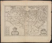
Covers Africa from the Mediterranean to the Ruwenzori Mountains., Dedication: Viro amplissimo pientissimoque Iohanni Brunaeo, IC. et illustrium Zelandiae Ordinum Syndico meritissimo, Nicolaus Blancardus, eorum dem Ordinum Historicus dedicabat L.M.Q., and Relief
Publisher:
Jan Jansson,
Subject (Geographic):
Africa--History--Maps--Early works to 1800
Subject (Name):
Brune, Johan de, 1588-1658 and Jansson, Jan, 1588-1664
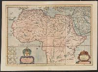
Includes col. ill. of ships, monsters, etc., Possibly from the 1639, 1641, or 1642 ed. of the author's Noveau theatre du monde ou nouvel atlas, or from the 1646, 1647, or 1649 ed. of J. Jansson's Nouvel atlas ou theatre du monde., and Relief shown pictorially.
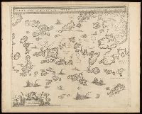
Archipelagi meridionalis, seu Cycladvm Insularum accurata delineatio
Description:
Includes three bar scales., Manuscript number in upper left corner: 33., Relief shown pictorially., and Verso blank.
Publisher:
[Jan Jansson],
Subject (Geographic):
Aegean Islands (Greece and Turkey)--Maps--Early works to 1800., Cyclades (Greece)--Maps--Early works to 1800., Dodecanese Islands (Greece)--Maps--Early works to 1800., and Sporades (Greece)--Maps--Early works to 1800.
Appears in Jansson's historical atlas editions from 1652-1684., Hand colored., and Relief shown pictorially.
Publisher:
Apud Joannem Janssonium,
Subject (Geographic):
Benelux countries--Historical geography--Maps--Early works to 1800., Benelux countries--Maps--Early works to 1800., Europe, Central--Historical geography--Maps--Early works to 1800., Europe, Central--Maps--Early works to 1800., Europe, Eastern--Historical geography--Maps--Early works to 1800., Europe, Eastern--Maps--Early works to 1800., Germany--Historical geography--Maps--Early works to 1800., and Germany--Maps--Early works to 1800.
Subject (Name):
Jansson, Jan, 1588-1664
Subject (Topic):
Ethnology--Europe--Maps--Early works to 1800. and Germanic peoples--Maps--Early works to 1800.
Insvlarvm archipelagi septentrionalis seu Maris Aegaei accurata delineatio
Description:
Coordinates not present on map and are approximated., Includes four bar scales., Manuscript number in upper left corner: 32., Relief shown pictorially., and Verso blank.
Publisher:
[Jan Jansson],
Subject (Geographic):
Aegean Islands (Greece and Turkey)--Maps--Early works to 1800.
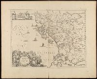
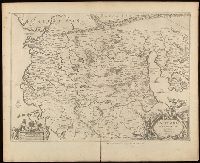
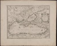
Relief shown pictorially., Verso blank., and Watermark. Manuscript number in upper left corner: 27. Manuscript annotations below neat line.
Publisher:
[Jan Jansson],
Subject (Geographic):
Albania, Albania--Maps--Early works to 1800., Europe--Macedonia, Greece--Maps--Early works to 1800., Macedonia (Republic)--Maps--Early works to 1800., and Macedonia--Maps--Early works to 1800.
Nova totivs terrarvm orbis geographica ac hydrographica tabvla
Description:
Appears in Jan Jansson's Appendix novi Atlantis (1637) and Jan Jansson and Hendrik Hondius's Atlas novus (1638)., Double hemisphere on sheet, with portraits of Ptolemy, J. Hondius, Caesar and Mercator., Relief shown pictorially., and With dedication to David Sanclarus, Antonius de Willon and Martinius by Hendrik Hondius, dated 1630.
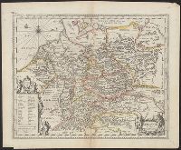
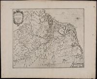
Manuscript number in upper left corner: 12., Map of the dominions of Charlemagne, showing rivers, hills, settlements, and other topographical features., North oriented towards the right., and Relief shown pictorially.
Publisher:
[Jan Jansson],
Subject (Geographic):
Benelux countries--Maps--Early works to 1800.
Subject (Name):
Charlemagne, Emperor, 742-814, Jansson, Jan, 1588-1664, and Saevery, S.
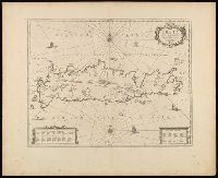
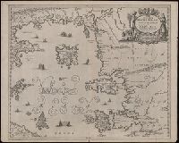
Coordinates not present on map and are approximated., Includes four bar scales., Relief shown pictorially., Verso blank., and Watermark. Manuscript number in upper left corner: 31. Manuscript annotation at top: Thebo.
Publisher:
[Jan Jansson],
Subject (Geographic):
Peloponnesus (Greece : Peninsula)--Maps--Early works to 1800.
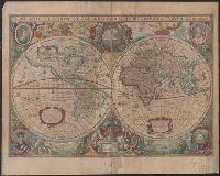
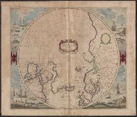
Cross collection no. 48., From: Mercator's Atlas, or, A geographicke description of the regions, countries and kingdoms of the world [1641?], Includes decorative title cartouche, blank dedication cartouche, and four illustrations (colored engravings) of Arctic whaling scenes., Polar projection., and Relief shown pictorially.
Publisher:
Jan Jansson and Hendrik Hondius,
Subject (Geographic):
Arctic Regions--Maps--Early works to 1800, North Pole--Maps--Early works to 1800, and Northern Hemisphere--Maps--Early works to 1800
Subject (Name):
Jansson, Jan, 1588-1664 and Mercator, Gerhard, 1512-1594. Atlas, or, A geographicke description of the regions, countries and kingdomes of the world
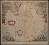
Appears in J. Jansson and H. Hondius' Atlas novus., Includes marginal ill. and title and blank cartouches., Latin text on verso., and Relief shown pictorially.
Publisher:
H. Hondius and J. Jansson,
Subject (Geographic):
Antarctica--Maps--Early works to 1800 and Southern Hemisphere--Maps--Early works to 1800
Subject (Name):
Jansson, Jan, 1588-1664 and Jansson, Jan, 1588-1664. Atlas novus