Skip to search
Skip to main content
Skip to first result
Search
You Searched For
Subject (Name)
Kitchin, Thomas, d. 1784
Search Results
Creator:
Published / Created:
[1769]
Call Number:
40 1777
Container / Volume:
BRBL_00198
Image Count:
1
Resource Type:
Maps, Atlases & Globes
Description:
Date from entry in catalog of the Royal Geographical Society.
Publisher:
John Bowles ... and Carrington Bowles,
Subject (Geographic):
Italy--Maps--Early works to 1800
Subject (Name):
Bowles, Carington, 1724-1793, Bowles, John, 1701-1779, Kitchin, Thomas, d. 1784, and Palairet, Jean, 1697-1774
Found in:
Beinecke Rare Book and Manuscript Library > A map of Italy / by Mr. Palairet with improvements & additions from the best authorities by L. Delarochette ; Tho Kitchin sculpt.
Creator:
Published / Created:
176-?]
Call Number:
71 1760B
Container / Volume:
BRBL_00364
Image Count:
1
Resource Type:
Maps, Atlases & Globes
Description:
Annotated in pencil: 1769, from Blair's Chronology.
Publisher:
s.n.,
Subject (Geographic):
North America--Maps--Early works to 1800
Subject (Name):
Kitchin, Thomas, d. 1784
Found in:
Beinecke Rare Book and Manuscript Library > A map of North America, from the latest surveys and maps / by John Blair as a supplement to his Tables of chronology ; Thos. Kitchin, sculpsit.
Creator:
Published / Created:
July the 1st, 1787.
Call Number:
90 1787
Container / Volume:
BRBL_00661
Image Count:
2
Resource Type:
Maps, Atlases & Globes
Alternative Title:
Chart of the Falkland's Islands.
Description:
Also appeared in Kitchin's General atlas describing the whole universe. London : Printed for Robert Sayer, [1780].
Publisher:
Printed for Robert Sayer,
Subject (Geographic):
Falkland Islands--Maps--Early works to 1800 and South America--Maps--Early works to 1800
Subject (Name):
Anville, Jean Baptiste Bourguignon d', 1697-1782, Kitchin, Thomas, d. 1784, and Kitchin, Thomas, d. 1784. General atlas describing the whole universe
Found in:
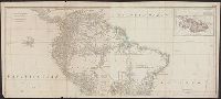
Beinecke Rare Book and Manuscript Library > A map of South America : containing Tierra-Firma, Guayana, New Granada, Amazonia, Brasil, Peru, Paraguay, Chaco, Tucuman, Chili and Patagonia : from Mr. d'Anville with several improvements and additions, and the newest discoveries.
Creator:
Published / Created:
[1773]
Call Number:
71 1773
Container / Volume:
BRBL_00365
Image Count:
4
Resource Type:
Maps, Atlases & Globes
Description:
"Longitude west from London."
Publisher:
Printed for Jefferys and Faden, geographers to the King,
Subject (Geographic):
North America--Maps--Early works to 1800
Subject (Name):
Jefferys and Faden, London and Kitchin, Thomas, d. 1784
Subject (Topic):
British--America--Maps--Early works to 1800
Found in:
Beinecke Rare Book and Manuscript Library > A map of the British and French dominions in North America : with the roads, distances, limits, and extent of the settlements, humbly inscribed to the Right Honourable the Earl of Halifax, and the other Right Honourable the Lords Commissioners for Trade &
Creator:
Published / Created:
[1775?]
Call Number:
71 1755A
Container / Volume:
BRBL_00363
Image Count:
8
Resource Type:
Maps, Atlases & Globes
Description:
Fourth ed.
Publisher:
Printed for Jefferys and Faden, geographers to the King,
Subject (Geographic):
North America--Maps--Early works to 1800
Subject (Name):
Jefferys and Faden, London and Kitchin, Thomas, d. 1784
Subject (Topic):
British--America--Maps--Early works to 1800
Found in:
Beinecke Rare Book and Manuscript Library > A map of the British colonies in North America : with the roads, distances, limits, and extent of the settlements, humbly inscribed to the Right Honourable the Earl of Halifax, and the other Right Honourable the Lords Commissioners for Trade & Plantations
Creator:
Published / Created:
1854]
Call Number:
771 N49 1776/1854
Container / Volume:
BRBL_00484
Image Count:
1
Resource Type:
Maps, Atlases & Globes
Alternative Title:
To his excellency Sir Henry Moore, Bart., Captain General & Governour in Chief in and over His Majesty's province of New York ... this plan of the city of New York & its environs ... is most humbly dedicated
Description:
"From D.T. Valentine's Manual, 1854."
Publisher:
s.n.,
Subject (Geographic):
New York (N.Y.)--Maps--Early works to 1800--Facsimiles
Subject (Name):
Hayward, George, b. ca. 1800, Kitchin, Thomas, d. 1784, and Valentine, D. T. (David Thomas), 1801-1869. Valentine's manual of old New York. 1854
Subject (Topic):
Maps--Facsimiles
Found in:
Beinecke Rare Book and Manuscript Library > Plan of the city of New York in North America, surveyed in the years 1766 & 1767 : to his excellency Sir Henry Moore, Bart., Captain General & Governour in Chief in and over His Majesty's province of New York ... this plan of the city of New York & its en