- Creator:
- Delarochette, L. (Louis), 1731-1802
- Published / Created:
- [1769]
- Call Number:
- 40 1777
- Container / Volume:
- BRBL_00198
- Image Count:
- 1
- Resource Type:
- Maps, Atlases & Globes
- Description:
- Date from entry in catalog of the Royal Geographical Society., Includes table "Methodical division of Italy.", Includes texts within the map explaining various political divisions and their histories., Includes three bar scales, onl, and Relief shown pictorially.
- Publisher:
- John Bowles ... and Carrington Bowles,
- Subject (Geographic):
- Italy--Maps--Early works to 1800
- Subject (Name):
- Bowles, Carington, 1724-1793, Bowles, John, 1701-1779, Kitchin, Thomas, d. 1784, and Palairet, Jean, 1697-1774
- Found in:
- Beinecke Rare Book and Manuscript Library > A map of Italy / by Mr. Palairet with improvements & additions from the best authorities by L. Delarochette ; Tho Kitchin sculpt.
You Searched For
1 - 6 of 6
Search Results
- Creator:
- Blair, John, d. 1782
- Published / Created:
- 176-?]
- Call Number:
- 71 1760B
- Container / Volume:
- BRBL_00364
- Image Count:
- 1
- Resource Type:
- Maps, Atlases & Globes
- Description:
- Annotated in pencil: 1769, from Blair's Chronology., DLC, Relief shown pictorially., and Yale's copy stamped on verso: Yale, Horace Brown, 1900S.
- Publisher:
- s.n.,
- Subject (Geographic):
- North America--Maps--Early works to 1800
- Subject (Name):
- Kitchin, Thomas, d. 1784
- Found in:
- Beinecke Rare Book and Manuscript Library > A map of North America, from the latest surveys and maps / by John Blair as a supplement to his Tables of chronology ; Thos. Kitchin, sculpsit.
- Creator:
- Sayer, Robert, 1725-1794
- Published / Created:
- July the 1st, 1787.
- Call Number:
- 90 1787
- Container / Volume:
- BRBL_00661
- Image Count:
- 2
- Resource Type:
- Maps, Atlases & Globes
- Alternative Title:
- Chart of the Falkland's Islands.
- Description:
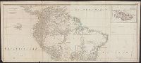
- Also appeared in Kitchin's General atlas describing the whole universe. London : Printed for Robert Sayer, [1780]., Includes descriptive notes and text "Division of South America with a summary account of its trade," and large ornamental cartouche., Inset map: Chart of the Falkland's Islands : named by the French Malouine Islands, and discovered by Hawkins in the year 1595. Scale [ca. 1:2,000,000]., Prime meridian: Ferro., Relief shown pictorially; depths by soundings., Sheets measures 54 x 122.7 cm., and Sheets mounted together to form 2 sheets.
- Publisher:
- Printed for Robert Sayer,
- Subject (Geographic):
- Falkland Islands--Maps--Early works to 1800 and South America--Maps--Early works to 1800
- Subject (Name):
- Anville, Jean Baptiste Bourguignon d', 1697-1782, Kitchin, Thomas, d. 1784, and Kitchin, Thomas, d. 1784. General atlas describing the whole universe
- Found in:
- Beinecke Rare Book and Manuscript Library > A map of South America : containing Tierra-Firma, Guayana, New Granada, Amazonia, Brasil, Peru, Paraguay, Chaco, Tucuman, Chili and Patagonia : from Mr. d'Anville with several improvements and additions, and the newest discoveries.
4.
- Creator:
- Mitchell, John, 1711-1768
- Published / Created:
- [1773]
- Call Number:
- 71 1773
- Container / Volume:
- BRBL_00365
- Image Count:
- 4
- Resource Type:
- Maps, Atlases & Globes
- Description:
- "Longitude west from London.", First impression of 3d ed., Includes text and inset "A new map of Hudson's Bay and Labrador from the late surveys of those coasts.", and Relief shown pictorially.
- Publisher:
- Printed for Jefferys and Faden, geographers to the King,
- Subject (Geographic):
- North America--Maps--Early works to 1800
- Subject (Name):
- Jefferys and Faden, London and Kitchin, Thomas, d. 1784
- Subject (Topic):
- British--America--Maps--Early works to 1800
- Found in:
- Beinecke Rare Book and Manuscript Library > A map of the British and French dominions in North America : with the roads, distances, limits, and extent of the settlements, humbly inscribed to the Right Honourable the Earl of Halifax, and the other Right Honourable the Lords Commissioners for Trade &
5.
- Creator:
- Mitchell, John, 1711-1768
- Published / Created:
- [1775?]
- Call Number:
- 71 1755A
- Container / Volume:
- BRBL_00363
- Image Count:
- 8
- Resource Type:
- Maps, Atlases & Globes
- Description:
- Fourth ed., In bottom margin: Publish'd by the author Febry 13th 1755 according to act of Parliament., Includes text and inset "A new map of Hudson's Bay and Labrador from the late surveys of those coasts.", Relief shown pictorially., and Yale's copy stamped on b
- Publisher:
- Printed for Jefferys and Faden, geographers to the King,
- Subject (Geographic):
- North America--Maps--Early works to 1800
- Subject (Name):
- Jefferys and Faden, London and Kitchin, Thomas, d. 1784
- Subject (Topic):
- British--America--Maps--Early works to 1800
- Found in:
- Beinecke Rare Book and Manuscript Library > A map of the British colonies in North America : with the roads, distances, limits, and extent of the settlements, humbly inscribed to the Right Honourable the Earl of Halifax, and the other Right Honourable the Lords Commissioners for Trade & Plantations
- Creator:
- Ratzer, Bernard
- Published / Created:
- 1854]
- Call Number:
- 771 N49 1776/1854
- Container / Volume:
- BRBL_00484
- Image Count:
- 1
- Resource Type:
- Maps, Atlases & Globes
- Alternative Title:
- To his excellency Sir Henry Moore, Bart., Captain General & Governour in Chief in and over His Majesty's province of New York ... this plan of the city of New York & its environs ... is most humbly dedicated
- Description:
- "From D.T. Valentine's Manual, 1854.", Facsimile., Includes decorative cartouche and ancillary view, A south west view of the city of New York taken from the Governour's Island at * [i.e. asterisk]., and Relief shown by hachures.
- Publisher:
- s.n.,
- Subject (Geographic):
- New York (N.Y.)--Maps--Early works to 1800--Facsimiles
- Subject (Name):
- Hayward, George, b. ca. 1800, Kitchin, Thomas, d. 1784, and Valentine, D. T. (David Thomas), 1801-1869. Valentine's manual of old New York. 1854
- Subject (Topic):
- Maps--Facsimiles
- Found in:
- Beinecke Rare Book and Manuscript Library > Plan of the city of New York in North America, surveyed in the years 1766 & 1767 : to his excellency Sir Henry Moore, Bart., Captain General & Governour in Chief in and over His Majesty's province of New York ... this plan of the city of New York & its en