Search
You Searched For
Search Results
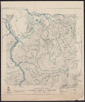
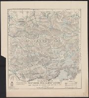
- Creator:
- Darby, O. A
- Published / Created:
- 1907
- Call Number:
- 267 T55 1907
- Container / Volume:
- BRBL_00023
- Image Count:
- 1
- Resource Type:
- Maps, Atlases & Globes
- Found in:
- Beinecke Rare Book and Manuscript Library > Topographical map of Toaroha survey district / compiled and drawn by O. A. Darby.
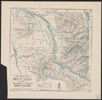
- Creator:
- Crawford, R. J
- Published / Created:
- 1908
- Call Number:
- 267cbf B64 1908
- Container / Volume:
- BRBL_00023A
- Image Count:
- 1
- Resource Type:
- Maps, Atlases & Globes
- Found in:
- Beinecke Rare Book and Manuscript Library > Topographical map of Mount Bonar and parts of Wanganui & Poerua survey districts / compiled and drawn by R.J. Crawford.
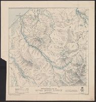
- Creator:
- Crawford, R. J
- Published / Created:
- 1907
- Call Number:
- 267 T64 1907
- Container / Volume:
- BRBL_00023
- Image Count:
- 1
- Resource Type:
- Maps, Atlases & Globes
- Found in:
- Beinecke Rare Book and Manuscript Library > Topographical map of Totara survey district / compiled and drawn by R. J. Crawford.
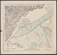
- Creator:
- Crawford, R. J
- Published / Created:
- 1908
- Call Number:
- 267cbf W1347 1908
- Container / Volume:
- BRBL_00023A
- Image Count:
- 1
- Resource Type:
- Maps, Atlases & Globes
- Found in:
- Beinecke Rare Book and Manuscript Library > Topographical map of Murray survey district; topographical map of Waitaha survey district / compiled and drawn by R.J. Crawford.
- Creator:
- Harris, G. E
- Published / Created:
- 1908
- Call Number:
- 267 W58 1908
- Container / Volume:
- BRBL_00023
- Image Count:
- 1
- Resource Type:
- Maps, Atlases & Globes
- Found in:
- Beinecke Rare Book and Manuscript Library > Topographical map of Whitcombe Pass survey district and portions of Poerua and Butler s.d.'s. / compiled and drawn by G. E. Harris.