Search
You Searched For
Search Results
- Creator:
- Longyear, John Munro, 1850-1922
- Published / Created:
- [between 1870 and 1879?]
- Call Number:
- BrSides Double Folio 2018 100
- Image Count:
- 1
- Resource Type:
- Maps, Atlases & Globes
- Found in:
- Beinecke Rare Book and Manuscript Library > Map of the Iron River silver district, Ontonagon County, Mich. / J.M. Longyear, sc.
- Creator:
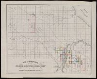
- Meads, A. P. (Alexander P.)
- Published / Created:
- [1899]
- Call Number:
- BrSides Double Folio 2018 99
- Image Count:
- 1
- Resource Type:
- Maps, Atlases & Globes
- Found in:
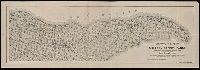
- Beinecke Rare Book and Manuscript Library > Sectional map of the Michigan Copper Range [cartographic material] : from Keweenaw Point to Lake Gogebic, showing the course and boundaries of the copper-bearing formation : also the exact location of the producing mines and those in progress of developme
- Creator:
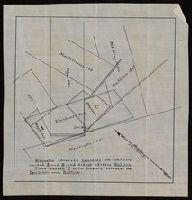
- Savigny, Hugh P
- Published / Created:
- [1870]
- Call Number:
- BrSides Double Folio 2018 101
- Image Count:
- 1
- Resource Type:
- Maps, Atlases & Globes
- Found in:
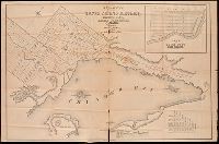
- Beinecke Rare Book and Manuscript Library > Plan of survey of the silver mining district, Thunder Bay, Lake Superior, Canada / compiled by Hugh P. Savigny, P.L.S.
- Creator:
- Johnson, Thomas H., Cartographer
- Published / Created:
- 2nd Feby. 1877.
- Call Number:
- BrSides Double Folio 2018 97
- Image Count:
- 1
- Resource Type:
- Maps, Atlases & Globes
- Found in:
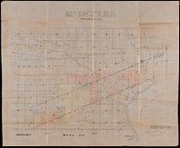
- Beinecke Rare Book and Manuscript Library > McIntyre / Thos. H. Johnson, Assistant Commissioner.
- Published / Created:
- [approximately 1900?]
- Call Number:
- BrSides Double Folio 2018 102
- Image Count:
- 1
- Resource Type:
- Maps, Atlases & Globes
- Found in:
- Beinecke Rare Book and Manuscript Library > [Partial cadastral map of the Province of Ontario in Canada].
- Creator:
- Milwaukee Lith. & Engr. Co.
- Published / Created:
- [1873?]
- Call Number:
- BrSides 2018 157
- Image Count:
- 1
- Resource Type:
- Maps, Atlases & Globes
- Found in:
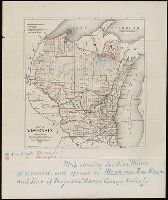
- Beinecke Rare Book and Manuscript Library > Map of Wisconsin : prepared for the legislative manual from offical records, 1873.
- Published / Created:
- [between 1875 and 1900?]
- Call Number:
- BrSides 2018 155
- Image Count:
- 1
- Resource Type:
- Maps, Atlases & Globes
- Found in:
- Beinecke Rare Book and Manuscript Library > [Manuscript map of mine locations in Michigan].
- Published / Created:
- [1859?]
- Call Number:
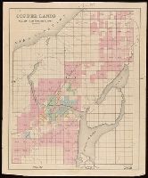
- BrSides Folio 2018 134
- Image Count:
- 1
- Resource Type:
- Maps, Atlases & Globes
- Found in:
- Beinecke Rare Book and Manuscript Library > Copper lands of St. Mary's Canal Mineral Land Co. shaded red.
- Creator:
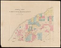
- J.O. Seymour & Co.
- Published / Created:
- [ca. 1870]
- Call Number:
- BrSides Folio 2018 132
- Image Count:
- 1
- Resource Type:
- Maps, Atlases & Globes
- Found in:
- Beinecke Rare Book and Manuscript Library > Map of property of the Globe Copper Company and mines in the Portage Lake District.
- Published / Created:
- [1859?]
- Call Number:
- BrSides Folio 2018 136
- Image Count:
- 1
- Resource Type:
- Maps, Atlases & Globes
- Found in:
- Beinecke Rare Book and Manuscript Library > Copper lands of St. Mary's Canal Mineral Land Co. shaded red.