
You Searched For
1 - 7 of 7
Search Results

- Creator:
- Petrini, Paolo
- Published / Created:
- [1766?]
- Call Number:
- 71 1766
- Container / Volume:
- BRBL_00364
- Image Count:
- 1
- Resource Type:
- Maps, Atlases & Globes
- Description:
- Relief shown pictorially. and Yale's copy stamped on backing: Yale University Library, Karpinski-Von Wieser Map Collection.
- Publisher:
- a spese di Paolo Petrini et da lui si vendono in Napoli a S. Biaggio de Librari,
- Subject (Geographic):
- North America--Maps--Early works to 1800
- Subject (Name):
- Donzel, Anton and Sanson, Nicolas, 1600-1667
- Found in:
- Beinecke Rare Book and Manuscript Library > America settentrionale : dedicata allèccell, sig. principe d'Auellino etc. ... corretta, et aumentata, secondo le relatione più moderne / da N. Sanson d'Abbeuile giografo di sua Maestà Christma. làn 1766 in Pariggi ; Antonius Donzel Gallus sculpsit.

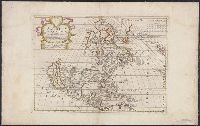
- Creator:
- Robert de Vaugondy, Didier, 1723-1786
- Published / Created:
- [1757?]
- Call Number:
- 3190 No. 5
- Container / Volume:
- BRBL_00041
- Image Count:
- 1
- Resource Type:
- Maps, Atlases & Globes
- Alternative Title:
- Britannicae Insulae in quibus Albion seu Britannia Major, et Ivernia seu Britannia Minor
- Description:
- "Cum Privilegio Regis.", Appears in Gilles Robert de Vaugondy's Atlas Universel (1752 and later)., Prime meridian: Ferro., and Relief shown pictorially.
- Publisher:
- [Gilles Robert de Vaugondy?],
- Subject (Geographic):
- British Isles--Historical geography--Maps--Early works to 1800
- Subject (Name):
- Haye, G. de la, Robert de Vaugondy, Gilles, 1688-1766. Atlas universel., and Sanson, Nicolas, 1600-1667
- Found in:
- Beinecke Rare Book and Manuscript Library > Britannicae Insulae in quibus Albion seu Britannia Major, et Iuernia seu Britannia Minor : juxta Ptolemaei mentem divisae, tùm in suas majores partes, tùm in populos exhibenturc / à Nicolao Sanson, Christ. Regis Geographo ; revisae, et ad observationes as
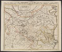
- Published / Created:
- [1710?]
- Call Number:
- 404 F41 1710
- Container / Volume:
- BRBL_00235
- Image Count:
- 1
- Resource Type:
- Maps, Atlases & Globes
- Publisher:
- Chez Pierre Mortier,
- Subject (Geographic):
- Ferrara (Italy : Province)--Maps--Early works to 1800
- Subject (Name):
- Catholic Church.--Diocese of Ferrara (Italy)--Maps--Early works to 1800, Mortier, Pierre, and Sanson, Nicolas, 1600-1667
- Found in:
- Beinecke Rare Book and Manuscript Library > Carte nouvelle du Duché et Legation de Ferrare a l'Eglise ... par le Sr. Sanson.
5.
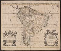
- Creator:
- Jaillot, Alexis Hubert, 1632?-1712
- Published / Created:
- 1694
- Call Number:
- 90 1694
- Container / Volume:
- BRBL_00697
- Image Count:
- 1
- Resource Type:
- Maps, Atlases & Globes
- Alternative Title:
- America meridionalis in suas praecipuas partes accurate divisa, ad usum serenissimi Burgundiae Ducis
- Description:
- Appears in Jaillot's Atlas françois., Cross Collection no. 324., Includes eight bar scales., Ms. no. in upper right corner: 14., Plate copied from Nicolas Sanson., Prime meridian: Ferro., and Watermark.
- Publisher:
- [Alexis Hubert Jaillot],
- Subject (Geographic):
- South America--Maps--Early works to 1800
- Subject (Name):
- Jaillot, Alexis Hubert, 1632?-1712. Atlas françois and Sanson, Nicolas, 1600-1667
- Found in:
- Beinecke Rare Book and Manuscript Library > L'Amérique méridionale divisée en ses principales parties : presenté à monseigneur le Duc de Bourgogne / par son tres humble et tres obeissant serviteur H. Iaillot.
6.
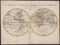
- Creator:
- Rossi, Giovanni Giacomo de, 17th cent
- Published / Created:
- 1674
- Call Number:
- 11 1674
- Container / Volume:
- BRBL_00680
- Image Count:
- 1
- Resource Type:
- Maps, Atlases & Globes
- Description:
- Cross collection no. 22. and Issued in Rossi's Mercurio geografico.
- Publisher:
- Da Gio. Iacomo de Rossi nella sua Stamperia in Roma alla Pace l'Anno,
- Subject (Name):
- Lhuilier, Jean, Rossi, Giovanni Giacomo de, 17th cent. Mercurio geografico, and Sanson, Nicolas, 1600-1667
- Subject (Topic):
- World maps--Early works to 1800
- Found in:
- Beinecke Rare Book and Manuscript Library > Mappa mondo o vero carta generale del globo terrestre [cartographic material] : rapresentato in due planisferi ... / da N. Sanson de Abbeville Giografo di sua Maesta Cristma ; intagliata da Gio. Lhuilier.
7.
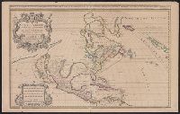
- Creator:
- Berry, William, fl. 1669-1708
- Published / Created:
- 1680
- Call Number:
- 71 1680
- Container / Volume:
- BRBL_00360
- Image Count:
- 1
- Resource Type:
- Maps, Atlases & Globes
- Alternative Title:
- North America divided into its pri[n]cipall parts, viz. Arctick lands, New North Wales, N. South Wales, N. Brittain, Canada, N. Fpance [sic], N. Scotland, N. England, N. York, N. Jarsey, Mary-Land, Virginia, Carolina, Florida, Mexico or N. Spain, N. Mexic
- Description:
- "Sold by William Berry at the sign of the globe between Charing-Cross and White-Hall, 1680." and Dedication: To the most serene and most sacred majesty of Charles II, by the grace of God, king of Great Brittain, France, and Ireland, this map of North America
- Publisher:
- William Berry,
- Subject (Geographic):
- France--Colonies--America--Maps--Early works to 1800, Great Britain--Colonies--America--Maps--Early works to 1800, North America--Maps--Early works to 1800, and Spain--Colonies--America--Maps--Early works to 1800
- Subject (Name):
- Sanson, Nicolas, 1600-1667
- Found in:
- Beinecke Rare Book and Manuscript Library > North America divided into its principall parts where are distinguished the severall states which belong to the English, Spanish, and French / described by Sanson ; corrected and amended by William Berry.