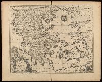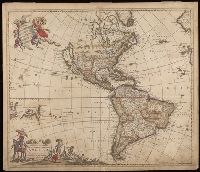
- Creator:
- Wit, Frederik de
- Call Number:
- BrSides Double Folio 2019 115
- Image Count:
- 1
- Resource Type:
- Maps, Atlases & Globes
- Description:
- "Cum Privilegio D.D. Ordinum Holl. Westfriliegs.", According to P.D. Burden, Mapping of North America, this is the seventh state of de Wit's map of America, with a new title engraved adding the privilege statement, lower case letters inserted between the latitude numbers and upper case letters between the longitude, and the longitudinal line 338° bearing a bad plate crack in the souther hemipshere, with an erased compass rose at the junction of 338° longitude and 10° north latitude., Appears in various editions of Wit's Atlas., Baked with paper., Number "2" in upper right corner., Prime meridian: Ferro., Relief shown pictorially., and Watermark.
- Subject (Geographic):
- America--Maps--Early works to 1800. and Western Hemisphere--Maps--Early works to 1800.
- Subject (Name):
- Wit, Frederik de
- Found in:
- Beinecke Rare Book and Manuscript Library > Novissima et accuratissima septentrionalis ac meridionalis Americae : descriptio, multis locis recentibus aucta et correcté divisa in omnes partes hodiernas / per Fredericum de Witt ; F. de Wit excudit.