Search
You Searched For
Search Results
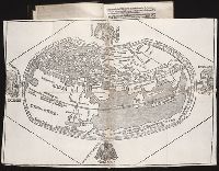
- Published / Created:
- [1509]
- Call Number:
- Taylor 46
- Collection Title:
- Cosmographia Pii Papae in Asiæ & Europæ eleganti descriptione : Asia. Historias rerum vbique
- Image Count:
- 1
- Found in:
- Beinecke Rare Book and Manuscript Library > [Map of the world]
- Creator:
- Hole, William, d. 1624, engraver
- Published / Created:
- [ca. 1606]
- Call Number:
- Taylor 301
- Collection Title:
- The generall historie of Virginia, New-England, and the Summer Iles : with the names of the
- Image Count:
- 1
- Found in:
- Beinecke Rare Book and Manuscript Library > Virginia
- Creator:
- National Geographic Society (U.S.)
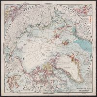
- Published / Created:
- 1907
- Call Number:
- 18 1907
- Container / Volume:
- BRBL_00013
- Image Count:
- 1
- Resource Type:
- Maps, Atlases & Globes
- Found in:
- Beinecke Rare Book and Manuscript Library > The National geographic magazine map of the North Pole regions / prepared by Gilbert H. Grosvenor, editor.
- Published / Created:
- [1540]
- Call Number:
- E33 +540P
- Collection Title:
- Geographia vniversalis, vetvs et nova complectens Clavdii Ptolemaei Alexandrini enarrationis libros
- Image Count:
- 1
- Resource Type:
- Maps, Atlases & Globes
- Found in:
- Beinecke Rare Book and Manuscript Library > Tabula Europae IX
- Published / Created:
- 1817
- Call Number:
- Folio Q115 H84 1B
- Collection Title:
- Atlas geographique et physique des regions equinoxiales du nouveau continent, fonde sur des
- Image Count:
- 1
- Resource Type:
- Maps, Atlases & Globes
- Found in:
- Beinecke Rare Book and Manuscript Library > Tableau physique des Ils Canaries. Geographie des plantes du Pic de Teneriffe
- Published / Created:
- 1820
- Call Number:
- Folio Q115 H84 1B
- Collection Title:
- Atlas geographique et physique des regions equinoxiales du nouveau continent, fonde sur des
- Image Count:
- 1
- Resource Type:
- Maps, Atlases & Globes
- Found in:
- Beinecke Rare Book and Manuscript Library > Profit du Chemin de Carthagene des Indes au Plateau de Santa Fe de Bogata. pl. 6
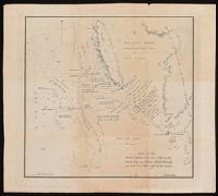
- Creator:
- Arrowsmith, John, 1790-1873, cartographer
- Published / Created:
- 1846
- Call Number:
- BrSides 2019 95
- Image Count:
- 1
- Resource Type:
- Maps, Atlases & Globes
- Found in:
- Beinecke Rare Book and Manuscript Library > Part of the west coast of Australia, surveyed by the officers of H.M.S. Beagle [cartographic material] : with Captn. J. Lort Stokes' route into the interior Decr. 1841 / J. Arrowsmith.
- Published / Created:
- [1859]
- Call Number:
- BrSides Folio 2018 143
- Image Count:
- 1
- Resource Type:
- Maps, Atlases & Globes
- Found in:
- Beinecke Rare Book and Manuscript Library > Map showing the route by road & navigation for connecting the Atlantic & Pacific Oceans [cartographic material] : to accompany S.J. Dawson's report of the red river expedition / compiled by Messrs. Bruce & Brunless.
- Creator:
- Bauman, William
Graphic Company
- Published / Created:
- [ca. 1879]
- Call Number:
- 18 1879
- Container / Volume:
- BRBL_00013
- Image Count:
- 1
- Resource Type:
- Maps, Atlases & Globes
- Found in:
- Beinecke Rare Book and Manuscript Library > Map of the north polar region / Wm. Bauman del.
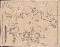
- Creator:
- Medary, Samuel A
- Published / Created:
- 1858
- Call Number:
- 8101 1858
- Container / Volume:
- BRBL_00552
- Image Count:
- 1
- Resource Type:
- Maps, Atlases & Globes
- Found in:
- Beinecke Rare Book and Manuscript Library > Map of the Fort Ridgely & South Pass road / by Samuel A. Medary ; drawn by John R. Key.