
You Searched For
« Previous
| 1 - 9 of 10 |
Next »
Search Results
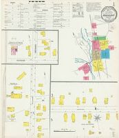
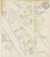
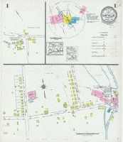
1. Danielson, Windham County, Connecticut.
- Creator:
- Sanborn Map Company, issuing body
- Published / Created:
- 1903
- Call Number:
- 766 D228 1903
- Image Count:
- 8
- Resource Type:
- Maps, Atlases & Globes
- Abstract:
- Sanborn fire insurance maps are a rich source of historic data on the urban built environment of North America during the 19th and early 20th centuries. The atlases were created for the purpose of underwriting fire insurance policies, which depended upon accurate and frequently-updated information about construction materials, municipal and transportation infrastructure, industrial and commercial landuse and more. The Yale University Library Map Department scanned its holdings of Sanborn fire insurance maps (consisting primarily of Connecticut towns) in order to make the maps more accessible.
- Alternative Title:
- July 1903, Danielson, Conn.
- Description:
- . "Triplicate" stamp on all sheets. Library of
- Subject (Geographic):
- Killingly (Conn. : Town)--Maps
- Subject (Name):
- Library of Congress Ownership
- Subject (Topic):
- Fire risk assessment--Connecticut--Killingly (Town)--Maps and Real property--Connecticut--Killingly (Town)--Maps
- Found in:
- Beinecke Rare Book and Manuscript Library > Danielson, Windham County, Connecticut.
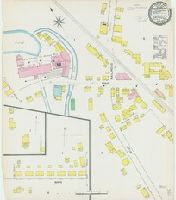
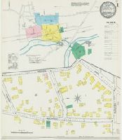
2. Dayville, Windham Co., Connecticut.
- Creator:
- Sanborn Map Company, issuing body
- Published / Created:
- 1892
- Call Number:
- 766 D337 1892
- Image Count:
- 1
- Resource Type:
- Maps, Atlases & Globes
- Abstract:
- Sanborn fire insurance maps are a rich source of historic data on the urban built environment of North America during the 19th and early 20th centuries. The atlases were created for the purpose of underwriting fire insurance policies, which depended upon accurate and frequently-updated information about construction materials, municipal and transportation infrastructure, industrial and commercial landuse and more. The Yale University Library Map Department scanned its holdings of Sanborn fire insurance maps (consisting primarily of Connecticut towns) in order to make the maps more accessible.
- Description:
- " stamp and Library of Congress copyright
- Subject (Geographic):
- Killingly (Conn. : Town)--Maps
- Subject (Name):
- Library of Congress Stamp
- Subject (Topic):
- Fire risk assessment--Connecticut--Killingly (Town)--Maps and Real property--Connecticut--Killingly (Town)--Maps
- Found in:
- Beinecke Rare Book and Manuscript Library > Dayville, Windham Co., Connecticut.
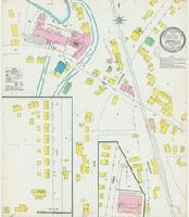
3. Dayville, Windham Co., Connecticut.
- Creator:
- Sanborn Map Company, issuing body
- Published / Created:
- 1903
- Call Number:
- 766 D337 1903
- Image Count:
- 1
- Resource Type:
- Maps, Atlases & Globes
- Abstract:
- Sanborn fire insurance maps are a rich source of historic data on the urban built environment of North America during the 19th and early 20th centuries. The atlases were created for the purpose of underwriting fire insurance policies, which depended upon accurate and frequently-updated information about construction materials, municipal and transportation infrastructure, industrial and commercial landuse and more. The Yale University Library Map Department scanned its holdings of Sanborn fire insurance maps (consisting primarily of Connecticut towns) in order to make the maps more accessible.
- Description:
- " stamp and Library of Congress copyright
- Subject (Geographic):
- Killingly (Conn. : Town)--Maps
- Subject (Name):
- Library of Congress Stamp
- Subject (Topic):
- Fire risk assessment--Connecticut--Killingly (Town)--Maps and Real property--Connecticut--Killingly (Town)--Maps
- Found in:
- Beinecke Rare Book and Manuscript Library > Dayville, Windham Co., Connecticut.
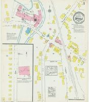
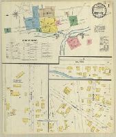
4. Dayville, Windham County, Connecticut.
- Creator:
- Sanborn Map Company, issuing body
- Published / Created:
- 1917
- Call Number:
- 766 D337 1917
- Image Count:
- 2
- Resource Type:
- Maps, Atlases & Globes
- Abstract:
- Sanborn fire insurance maps are a rich source of historic data on the urban built environment of North America during the 19th and early 20th centuries. The atlases were created for the purpose of underwriting fire insurance policies, which depended upon accurate and frequently-updated information about construction materials, municipal and transportation infrastructure, industrial and commercial landuse and more. The Yale University Library Map Department scanned its holdings of Sanborn fire insurance maps (consisting primarily of Connecticut towns) in order to make the maps more accessible.
- Alternative Title:
- Mar. 1917, Dayville, Conn.
- Description:
- . Library of Congress copyright stamp on title
- Subject (Geographic):
- Killingly (Conn. : Town)--Maps
- Subject (Name):
- Library of Congress Stamp
- Subject (Topic):
- Fire risk assessment--Connecticut--Killingly (Town)--Maps and Real property--Connecticut--Killingly (Town)--Maps
- Found in:
- Beinecke Rare Book and Manuscript Library > Dayville, Windham County, Connecticut.
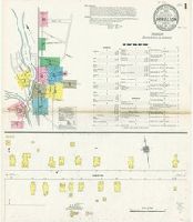
5. Danielsonville, CT.
- Creator:
- Sanborn Map & Publishing Co., issuing body
- Published / Created:
- 1884
- Call Number:
- 776 D228 1884
- Image Count:
- 2
- Resource Type:
- Maps, Atlases & Globes
- Abstract:
- Sanborn fire insurance maps are a rich source of historic data on the urban built environment of North America during the 19th and early 20th centuries. The atlases were created for the purpose of underwriting fire insurance policies, which depended upon accurate and frequently-updated information about construction materials, municipal and transportation infrastructure, industrial and commercial landuse and more. The Yale University Library Map Department scanned its holdings of Sanborn fire insurance maps (consisting primarily of Connecticut towns) in order to make the maps more accessible.
- Alternative Title:
- Dec. 1884, Danielsonville, Conn.
- Description:
- . "Triplicate" stamp on both sheets. Library of
- Subject (Geographic):
- Killingly (Conn. : Town)--Maps
- Subject (Name):
- Library of Congress Stamp
- Subject (Topic):
- Fire risk assessment--Connecticut--Killingly (Town)--Maps and Real property--Connecticut--Killingly (Town)--Maps
- Found in:
- Beinecke Rare Book and Manuscript Library > Danielsonville, CT.
6. Danielson, Windham County, Connecticut.
- Creator:
- Sanborn Map Company, issuing body
- Published / Created:
- 1911
- Call Number:
- 766 D228 1911
- Image Count:
- 10
- Resource Type:
- Maps, Atlases & Globes
- Abstract:
- Sanborn fire insurance maps are a rich source of historic data on the urban built environment of North America during the 19th and early 20th centuries. The atlases were created for the purpose of underwriting fire insurance policies, which depended upon accurate and frequently-updated information about construction materials, municipal and transportation infrastructure, industrial and commercial landuse and more. The Yale University Library Map Department scanned its holdings of Sanborn fire insurance maps (consisting primarily of Connecticut towns) in order to make the maps more accessible.
- Alternative Title:
- May 1911, Danielson, Conn.
- Description:
- . Library of Congress copyright stamp on title
- Subject (Geographic):
- Killingly (Conn. : Town)--Maps
- Subject (Name):
- Library of Congress Ownership
- Subject (Topic):
- Fire risk assessment--Connecticut--Killingly (Town)--Maps and Real property--Connecticut--Killingly (Town)--Maps
- Found in:
- Beinecke Rare Book and Manuscript Library > Danielson, Windham County, Connecticut.
7. Danielsonville, Windham County, CT.
- Creator:
- Sanborn-Perris Map Co., issuing body
- Published / Created:
- 1892
- Call Number:
- 776 D228 1892
- Image Count:
- 4
- Resource Type:
- Maps, Atlases & Globes
- Abstract:
- Sanborn fire insurance maps are a rich source of historic data on the urban built environment of North America during the 19th and early 20th centuries. The atlases were created for the purpose of underwriting fire insurance policies, which depended upon accurate and frequently-updated information about construction materials, municipal and transportation infrastructure, industrial and commercial landuse and more. The Yale University Library Map Department scanned its holdings of Sanborn fire insurance maps (consisting primarily of Connecticut towns) in order to make the maps more accessible.
- Alternative Title:
- June 1892, Danielsonville, Conn.
- Description:
- . "Triplicate" stamp on all sheets. Library of
- Subject (Geographic):
- Killingly (Conn. : Town)--Maps
- Subject (Name):
- Library of Congress Stamp
- Subject (Topic):
- Fire risk assessment--Connecticut--Killingly (Town)--Maps and Real property--Connecticut--Killingly (Town)--Maps
- Found in:
- Beinecke Rare Book and Manuscript Library > Danielsonville, Windham County, CT.
8. Danielson, Windham Co., Conn.
- Creator:
- Sanborn-Perris Map Co., issuing body
- Published / Created:
- 1897
- Call Number:
- 766 D228 1897
- Image Count:
- 5
- Resource Type:
- Maps, Atlases & Globes
- Abstract:
- Sanborn fire insurance maps are a rich source of historic data on the urban built environment of North America during the 19th and early 20th centuries. The atlases were created for the purpose of underwriting fire insurance policies, which depended upon accurate and frequently-updated information about construction materials, municipal and transportation infrastructure, industrial and commercial landuse and more. The Yale University Library Map Department scanned its holdings of Sanborn fire insurance maps (consisting primarily of Connecticut towns) in order to make the maps more accessible.
- Alternative Title:
- May 1897, Danielson, Conn.
- Description:
- . "Triplicate" stamp on all sheets. Library of
- Subject (Geographic):
- Killingly (Conn. : Town)--Maps
- Subject (Name):
- Library of Congress Ownership
- Subject (Topic):
- Fire risk assessment--Connecticut--Killingly (Town)--Maps and Real property--Connecticut--Killingly (Town)--Maps
- Found in:
- Beinecke Rare Book and Manuscript Library > Danielson, Windham Co., Conn.
9. Dayville, Windham County, Connecticut.
- Creator:
- Sanborn Map Company, issuing body
- Published / Created:
- 1927
- Call Number:
- 766 D337 1927
- Image Count:
- 3
- Resource Type:
- Maps, Atlases & Globes
- Abstract:
- Sanborn fire insurance maps are a rich source of historic data on the urban built environment of North America during the 19th and early 20th centuries. The atlases were created for the purpose of underwriting fire insurance policies, which depended upon accurate and frequently-updated information about construction materials, municipal and transportation infrastructure, industrial and commercial landuse and more. The Yale University Library Map Department scanned its holdings of Sanborn fire insurance maps (consisting primarily of Connecticut towns) in order to make the maps more accessible.
- Alternative Title:
- Aug. 1927, Dayville, Conn.
- Description:
- . Library of Congress copyright stamp on title
- Subject (Geographic):
- Killingly (Conn. : Town)--Maps
- Subject (Name):
- Library of Congress Stamp
- Subject (Topic):
- Fire risk assessment--Connecticut--Killingly (Town)--Maps and Real property--Connecticut--Killingly (Town)--Maps
- Found in:
- Beinecke Rare Book and Manuscript Library > Dayville, Windham County, Connecticut.