Skip to search
Skip to main content
Skip to first result
Search
You Searched For
Subject (Topic)
Maps
Search Results
Creator:
Published / Created:
[ca. 1700]
Call Number:
1973 Folio 18
Image Count:
2
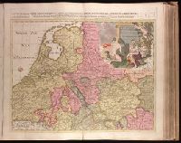
Alternative Title:
Table geographique dans la quelle fort distinctement, est montré la Partie Meridionale ou Superieure du Rhein, Meuse, Moselle and Table geographique dans la quelle fort distinctement, est montré la Partie Septentrionale ou Inferieure du Rhein, Meuse et Moselle
Description:
BEIN 1973 Folio 18: Backed with paper. Ms. no. "30" in upper right-hand corner or north sheet; ms. no. "31" in upper right-hand corner or south sheet. No. 30 of 87 maps bound together.
Publisher:
Chez Pierre Schenk ...
Subject (Geographic):
Rhine River
Subject (Topic):
Maps
Found in:
Beinecke Rare Book and Manuscript Library > Le cours de la riviere du Rhein depuis sa source jusques a son emboucheure, ou sont distingués toutes les estats et souverainetés qui sont dessus et aux environs / [cartographic material]
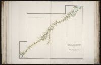
Creator:
Published / Created:
[1755]
Call Number:
2003 Folio 85
Image Count:
1
Resource Type:
cartographic image
Description:
BEIN 2003 Folio 85: No. 5 of 45 maps bound together with binder's spine title: Atlas of America; ms. table of contents. Bookplate of Paul Mellon.
Publisher:
Jean Baptiste Bourguignon d'Anville
Subject (Geographic):
Saint Lawrence River
Subject (Topic):
Maps
Found in:
Beinecke Rare Book and Manuscript Library > Le fleuve Saint-Laurent : représenté plus en detail que dans l'étendue de la carte
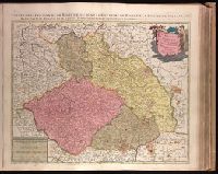
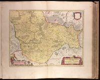
Creator:
Published / Created:
[ca. 1700]
Call Number:
1973 Folio 18
Image Count:
1
Alternative Title:
Estats de la couronne de Boheme, ou, Sont le royaume de Boheme, duché de Silésie, les marquisat de Moravie et de Lusace subdivisés en leurs principales parties / dressé sur les memoires les plus nouveaux par Sanson and Sont le royaume de Boheme, duché de Silésie, les marquisat de Moravie et de Lusace subdiviseés en leurs principales parties
Description:
BEIN 1973 Folio 18: Backed with paper. Ms. no. in upper right corner: 25. Sheet measures 53.7 x 62.7 cm. No. 25 of 87 maps bound together.
Publisher:
Chez Pierre Schenck, avec privilege de nos Seigneurs les Etats de Hollande et de West-Frise
Subject (Geographic):
Czech Republic, Saxony (Germany), and Poland
Subject (Topic):
Maps
Found in:
Beinecke Rare Book and Manuscript Library > Le royaume de Boheme, duché de Silésie, les marquisat de Moravie et de Lusace [cartographic material]
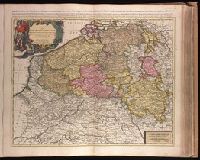
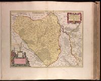
Creator:
Published / Created:
[ca. 1700?]
Call Number:
1973 Folio 18
Image Count:
1
Alternative Title:
Provinces des Pays Bas catholiques, restées pour la pluspart sous l'obeissance du roy d'Espagne
Description:
BEIN 1973 Folio 18: Backed with paper. Ms. no. "39" in upper-right corner. Sheet measures 53.5 x 62.4 cm. No. 38 of 87 maps bound together.
Publisher:
Chez P. Schenk
Subject (Geographic):
Benelux countries and France, Northern
Subject (Topic):
Maps
Found in:
Beinecke Rare Book and Manuscript Library > Les Provinces des Pays-Bas catholiques distinguées suivant qelles sont presentement partagées entre le Roy de France, le Roy d'Espagne et les Estats Generaux des Provinces-Unies / [cartographic material]
Creator:
Published / Created:
nel mese di giugno, del MDXXVIII [1528]
Call Number:
Taylor 67
Image Count:
170
Description:
BEIN Taylor 67: Annotations in final two quires in contemporary hand.
Publisher:
per Nicolo d'Aristotile, detto Zoppino
Subject (Geographic):
America
Subject (Topic):
Islands and Maps
Found in:
Beinecke Rare Book and Manuscript Library > Libro di Benedetto Bordone : nel qual si ragiona de tutte l'isole del mondo : con li lor nomi antichi & moderni, historie, fauole, & modi del loro uiuere, & in qual parte del mare stanno, & in qual parallelo & clima giacciono : con el breve di Papa Leone : et gratia & priuilegio della illustrissima Signoria com' in quelli appare, M.D.XXVIII
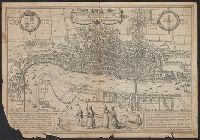
Creator:
Published / Created:
[1574]
Call Number:
32 L84 1572
Image Count:
2
Resource Type:
cartographic image
Description:
BEIN 32 L84 1572: Manuscript annotations on verso in pencil and ink offering and justifying potential dates of 1561 and 1572.
Publisher:
Braun and Hogenberg
Subject (Geographic):
London (England)
Subject (Topic):
Maps and Early works to 1800
Found in:
Beinecke Rare Book and Manuscript Library > Londinum feracissimi Angliae Regni metropolis
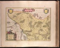
Creator:
Published / Created:
ca. 1670]
Call Number:
1973 Folio 18
Image Count:
1
Alternative Title:
Marchionatus Brandenburgici pars, quae marchia media vulgo Mittelmarck audit
Description:
BEIN 1973 Folio 18: Backed with paper. Ms. no. in upper right corner: 19. Sheet measures 53.7 x 63.4 cm. No. 19 of 87 maps bound together.
Publisher:
Excud. Joannes Blaeu
Subject (Geographic):
Brandenburg (Germany : Landkreis)
Subject (Topic):
Maps
Found in:
Beinecke Rare Book and Manuscript Library > March. Brandenburgici pars, quae marchia media vulgo Mittelmarck audit [cartographic material].
Creator:
Published / Created:
ca. 1670]
Call Number:
1973 Folio 18
Image Count:
1
Description:
BEIN 1973 Folio 18: Backed with paper. Ms. no. in upper right corner: 21. Sheet measures 53.7 x 62.5 cm. No. 21 of 87 maps bound together.
Publisher:
Joan Blaeu
Subject (Geographic):
Saxony-Anhalt (Germany)
Subject (Topic):
Maps
Found in:
Beinecke Rare Book and Manuscript Library > Marchionatus Brandenburgici pars, quae marchia vetus, vulgo Altemarck dicitur [cartographic material].
Creator:
Published / Created:
ca. 1670]
Call Number:
1973 Folio 18
Image Count:
1
Description:
BEIN 1973 Folio 18: Backed with paper. Ms. no. in upper right corner: 18. Sheet measures 53.6 x 62.9 cm. No. 18 of 87 maps bound together.
Publisher:
Joan Blaeu
Subject (Geographic):
Brandenburg (Germany : Landkreis)
Subject (Topic):
Maps
Found in:
Beinecke Rare Book and Manuscript Library > Marchionatus Brandenburgici partes duae, Ruppin Comitatus & Prignits regiuncula [cartographic material]
Creator:
Published / Created:
ca. 1670]
Call Number:
1973 Folio 18
Image Count:
1
Description:
BEIN 1973 Folio 18: Backed with paper. Ms. no. in upper right corner: 20. Sheet measures 53.7 x 62.8 cm. No. 20 of 87 maps bound together.
Publisher:
Joan Blaeu
Subject (Geographic):
Brandenburg (Germany : Landkreis) and Województwo Zachodniopomorskie (Poland)
Subject (Topic):
Maps
Found in:
Beinecke Rare Book and Manuscript Library > Marchionatus Brandenburgici partes duae, nova Marchia et Uckerana [cartographic material]