Search
You Searched For
Search Results
- Creator:
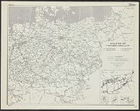
- United States. Office of Strategic Services. Research and Analysis Branch
- Published / Created:
- 1943
- Call Number:
- 36cb 1943
- Container / Volume:
- BRBL_00127
- Image Count:
- 1
- Resource Type:
- Maps, Atlases & Globes
- Alternative Title:
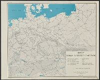
- Germany, terrain and selected railroads.
- Description:
- "Map no. 2905, 21 December 1943."
- Publisher:
- Lithographed in the Reproduction Branch, OSS,
- Subject (Geographic):
- Europe, Central--Maps and Germany--Maps
- Subject (Topic):
- Railroads--Europe, Central--Maps and Railroads--Germany--Maps
- Found in:
- Beinecke Rare Book and Manuscript Library > Germany, terrain & selected railroads / compiled and drawn in the Branch of Research and Analysis, OSS.
- Creator:
- United States. Office of Strategic Services. Research and Analysis Branch
- Published / Created:
- 1943
- Call Number:
- 36cb 1943
- Container / Volume:
- BRBL_00127
- Image Count:
- 1
- Resource Type:
- Maps, Atlases & Globes
- Alternative Title:
- Germany, terrain and selected railroads.
- Description:
- "Map no. 2905, 21 December 1943."
- Publisher:
- Lithographed in the Reproduction Branch, OSS,
- Subject (Geographic):
- Europe, Central--Maps and Germany--Maps
- Subject (Topic):
- Railroads--Europe, Central--Maps and Railroads--Germany--Maps
- Found in:
- Beinecke Rare Book and Manuscript Library > Germany, terrain & selected railroads / compiled and drawn in the Branch of Research and Analysis, OSS.
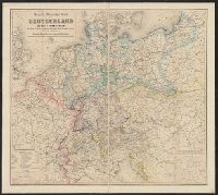
- Creator:
- Goldschmidt, Albert
Kraatz, Leopold
- Published / Created:
- [1871?]
- Call Number:
- 36 1871
- Container / Volume:
- BRBL_00120
- Image Count:
- 1
- Resource Type:
- Maps, Atlases & Globes
- Publisher:
- Verlag von Albert Goldschmidt,
- Subject (Geographic):
- Europe, Central--Maps and Germany--Maps
- Subject (Topic):
- Railroads--Europe, Central--Maps, Railroads--Germany--Maps, Steamboats--Europe, Central--Maps, and Steamboats--Germany--Maps
- Found in:
- Beinecke Rare Book and Manuscript Library > Neue-Karte von Deutschland und den angrenzenden Ländern : mit besonderer Berücksichtigung der Eisenbahn und Dampfboot-Course / nach den neusten und besten Quellen bearbeitet von Leopold Kraatz.
- Creator:
- Hendschel, U
- Published / Created:
- 1879
- Call Number:
- 304gm 1867A
- Container / Volume:
- BRBL_00034B
- Image Count:
- 1
- Resource Type:
- Maps, Atlases & Globes
- Publisher:
- Carl J"ugel,
- Subject (Topic):
- Railroads--Europe, Central--Maps
- Found in:
- Beinecke Rare Book and Manuscript Library > Neueste Eisenbahn-Karte von Central-Europa mit genauer Angabe aller Stationen un der influirenden Post-Verbindungen / von U. Hendschel.
- Creator:
- Mayr, J. G
- Published / Created:
- [1866?]
- Call Number:
- 36 1866A
- Container / Volume:
- BRBL_00120
- Image Count:
- 2
- Resource Type:
- Maps, Atlases & Globes
- Alternative Title:
- Neueste Uebersichts-Karte von Deutschland und Ost-Frankreich
- Description:
- Inset map: Uebersichts Karte der Haupt Entfernungen (Distanzen) ...
- Publisher:
- Verlag des Matth. Riegerschen Universitaets Buchhandlung,
- Subject (Geographic):
- Europe, Central--Maps and Germany--Maps
- Subject (Topic):
- Post roads--Europe, Central--Maps, Railroads--Europe, Central--Maps, Steamboats--Europe, Central--Maps, and Telegraph lines--Europe, Central--Maps
- Found in:
- Beinecke Rare Book and Manuscript Library > Neueste Übersichts-Karte von Deutschland und Ost-Frankreich : bis Paris, London, Kopenhagen, Warschau, Pesth, Venedig u[nd] Genua, in besonderer Rücksicht auf Eisenbahn-, Dampfschiff-, Post- u[nd] Telegraphen-Verbindungen, mit statistischen Distanz-Tabe
- Creator:
- United States. Office of Strategic Services. Research and Analysis Branch
- Published / Created:
- 1944
- Call Number:
- 36gme 1944
- Container / Volume:
- BRBL_00132
- Image Count:
- 1
- Resource Type:
- Maps, Atlases & Globes
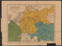
- Description:
- "Map no. 3131, 8 April 1944."
- Publisher:
- OSS,
- Subject (Geographic):
- Europe, Central--Maps and Germany--Maps
- Subject (Topic):
- Railroads--Europe, Central--Maps and Railroads--Germany--Maps
- Found in:
- Beinecke Rare Book and Manuscript Library > Railroad administration of "Greater Germany" / compiled and drawn in the Branch of Research and Analysis, OSS.
- Creator:
- United States. Office of Strategic Services. Research and Analysis Branch
- Published / Created:
- 1943
- Call Number:
- 36gme 1943C
- Container / Volume:
- BRBL_00132
- Image Count:
- 1
- Resource Type:
- Maps, Atlases & Globes
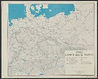
- Description:
- "Map no. 1958, January 8, 1943."
- Publisher:
- OSS,
- Subject (Geographic):
- Europe, Central--Maps and Germany--Maps
- Subject (Topic):
- Railroads--Europe, Central--Maps and Railroads--Germany--Maps
- Found in:
- Beinecke Rare Book and Manuscript Library > Railways of "Greater Germany" / compiled and drawn in the Branch of Research and Analysis, OSS.
- Creator:
- United States. Office of Strategic Services. Research and Analysis Branch
- Published / Created:
- 1944
- Call Number:
- 36gme 1944C
- Container / Volume:
- BRBL_00132
- Image Count:
- 1
- Resource Type:
- Maps, Atlases & Globes
- Description:
- "Map no. 2992, 8 April, 1944."
- Publisher:
- OSS,
- Subject (Geographic):
- Europe, Central--Maps and Germany--Maps
- Subject (Topic):
- Railroads--Europe, Central--Maps and Railroads--Germany--Maps
- Found in:
- Beinecke Rare Book and Manuscript Library > Railways of "Greater Germany" / compiled and drawn in the Branch of Research and Analysis, OSS.