Skip to search
Skip to main content
Skip to first result
Search
You Searched For
Subject (Topic)
Railroads--Louisiana--Maps
Search Results
Published / Created:
1860?]
Call Number:
796gme 1860
Container / Volume:
BRBL_00531
Image Count:
1
Resource Type:
Maps, Atlases & Globes
Alternative Title:
Red River, Sabine & Western Railway and Red River, Sabine and Western Railway
Description:
"I.[?] C. Terry, Chf. Eng."
Publisher:
s.n.,
Subject (Name):
Red River, Sabine and Western Railway--Maps and Streeter, Thomas W.--(Thomas Winthrop),--1883-1965--Ownership
Subject (Topic):
Coal--Texas--Maps, Forests and forestry--Louisiana--Maps, Forests and forestry--Texas--Maps, Iron--Texas--Maps, Petroleum--Texas--Maps, Railroads--Louisiana--Maps, and Railroads--Texas--Maps
Found in:
Beinecke Rare Book and Manuscript Library > A geographically correct map of the Red River, Sabine & Western Railway (under construction) and connections : showing distribution of pine forests (compiled from maps of U.S. government), also location of coal, iron, and oil deposits.
Creator:
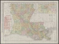
Published / Created:
1911
Call Number:
795 1911
Container / Volume:
BRBL_00521
Image Count:
1
Resource Type:
Maps, Atlases & Globes
Abstract:
Shows railroads overprinted in red.
Description:
Includes index and inset of "Vicinity of New Orleans" (scale [ca. 1:300,000]).
Publisher:
Rand McNally,
Subject (Geographic):
Louisiana--Maps
Subject (Topic):
Railroads--Louisiana--Maps
Found in:
Beinecke Rare Book and Manuscript Library > Louisiana.
Creator:
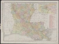
Published / Created:
1908
Call Number:
795 1908
Container / Volume:
BRBL_00521
Image Count:
2
Resource Type:
Maps, Atlases & Globes
Abstract:
Shows railroads overprinted in red.
Description:
Includes index and inset of "Vicinity of New Orleans" (scale [ca. 1:300,000]).
Publisher:
Rand McNally,
Subject (Geographic):
Louisiana--Maps
Subject (Topic):
Railroads--Louisiana--Maps
Found in:
Beinecke Rare Book and Manuscript Library > Louisiana.
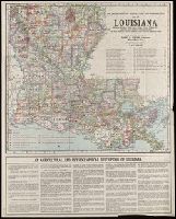
Published / Created:
[192-?]
Call Number:
795 192X
Container / Volume:
BRBL_00521
Image Count:
2
Resource Type:
Maps, Atlases & Globes
Alternative Title:
Map of Louisiana
Description:
"Issued under the direction of Harry D. Wilson, Commissioner."
Publisher:
Dept. of Agriculture and Immigration, State of Louisiana,
Subject (Geographic):
Louisiana--Maps
Subject (Name):
George F. Cram Company and Louisiana. Dept. of Agriculture and Immigration
Subject (Topic):
Mines and mineral resources--Louisiana--Maps, Railroads--Louisiana--Maps, and Roads--Louisiana--Maps
Found in:
Beinecke Rare Book and Manuscript Library > The Department of Agriculture and Immigration's map of Louisiana : showing parishes, parish seats, cities, towns, villages, etc., railroads, with distances between stations, the state highway system - improved and proposed improved roads.