Search
You Searched For
Search Results
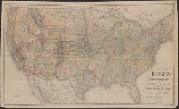
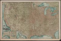
- Creator:
- Rand McNally and Company
- Published / Created:
- [1882?]
- Call Number:
- 75gme 1882A
- Container / Volume:
- BRBL_00413
- Image Count:
- 1
- Resource Type:
- Maps, Atlases & Globes
- Found in:
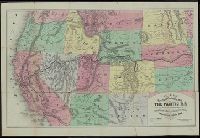
- Beinecke Rare Book and Manuscript Library > New map of the United States showing the complete railway system of the trans-Missouri country / prepared expressly for Crofutt's New overland tourist and Pacific coast guide, 1882, the Overland Publishing Company, Omaha, Neb., and Denver, Colo.
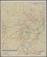
- Creator:
- Rand McNally and Company
- Published / Created:
- June 30th, 1904.
- Call Number:
- 80gme 1904A
- Container / Volume:
- BRBL_00540
- Image Count:
- 1
- Resource Type:
- Maps, Atlases & Globes
- Found in:
- Beinecke Rare Book and Manuscript Library > Rock Island-Frisco systems.
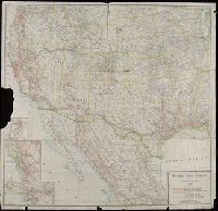
- Creator:
- Rand McNally and Company
- Published / Created:
- [1914]
- Call Number:
- 80gme 1914
- Container / Volume:
- BRBL_00540
- Image Count:
- 1
- Resource Type:
- Maps, Atlases & Globes
- Found in:
- Beinecke Rare Book and Manuscript Library > Southern Pacific Company and proprietary companies : 1914.
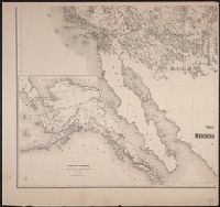
- Creator:
- Freyhold, Edward
- Published / Created:
- [1868]
- Call Number:
- 80 1868
- Container / Volume:
- BRBL_00535
- Image Count:
- 4
- Resource Type:
- Maps, Atlases & Globes
- Found in:
- Beinecke Rare Book and Manuscript Library > Territory of the United States from the Mississippi River to the Pacific Ocean : originally prepared to accompany the reports of the explorations for a Pacific railroad route / compiled from authorized explorations and other reliable data by G. K. Warren
- Creator:
- New England Railway Publishing Company
- Published / Created:
- c1902.
- Call Number:
- 75gme 1902B
- Container / Volume:
- BRBL_00414
- Image Count:
- 1
- Resource Type:
- Maps, Atlases & Globes
- Found in:
- Beinecke Rare Book and Manuscript Library > The ABC Pathfinder Railway Guide, Western Section / issued by the New England Railway Publishing Company.
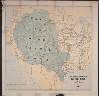
- Published / Created:
- 1885]
- Call Number:
- 80gc 1884
- Container / Volume:
- BRBL_00537
- Image Count:
- 1
- Resource Type:
- Maps, Atlases & Globes
- Found in:
- Beinecke Rare Book and Manuscript Library > The range and ranch cattle area of the United States : 1884.
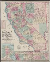
- Creator:
- Nell, Louis
- Published / Created:
- 1868
- Call Number:
- 844gme 1868
- Container / Volume:
- BRBL_00619
- Image Count:
- 1
- Resource Type:
- Maps, Atlases & Globes
- Found in:
- Beinecke Rare Book and Manuscript Library > Topographical railroad & county map of the states of California and Nevada : compiled from the latest explorations and other official information / by L. Nell.
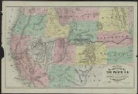
- Creator:
- Williams, Henry T
- Published / Created:
- [1876?]
- Call Number:
- 80gme 1876C
- Container / Volume:
- BRBL_00539
- Image Count:
- 2
- Resource Type:
- Maps, Atlases & Globes
- Found in:
- Beinecke Rare Book and Manuscript Library > Williams' new trans-continental map of the Pacific R.R. and routes of overland travel to Colorado, Nebraska, the Black Hills, Utah, Idaho, Nevada, Montana, California and the Pacific coast / Henry T. Williams.
- Creator:
- Williams, Henry T
- Published / Created:
- [1877?]
- Call Number:
- 80gme 1877A
- Container / Volume:
- BRBL_00539
- Image Count:
- 2
- Resource Type:
- Maps, Atlases & Globes
- Found in:
- Beinecke Rare Book and Manuscript Library > Williams' new trans-continental map of the Pacific R.R. and routes of overland travel to Colorado, Nebraska, the Black Hills, Utah, Idaho, Nevada, Montana, California, and the Pacific coast.
- Creator:
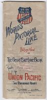
- Union Pacific Railway Company
- Published / Created:
- ca. 1893
- Call Number:
- Zc20 893wo
- Image Count:
- 9
- Resource Type:
- Books, Journals & Pamphlets
- Found in:
- Beinecke Rare Book and Manuscript Library > World’s pictorial line : birdseye view of the great Salt Lake Basin reached via the Union Pacific, the overland route