Search
You Searched For
Search Results
- Published / Created:
- 1877?]
- Call Number:
- 80gme 1877B
- Container / Volume:
- BRBL_00539
- Image Count:
- 2
- Resource Type:
- Maps, Atlases & Globes
- Found in:
- Beinecke Rare Book and Manuscript Library > A geographically correct map of the Kansas Pacific Railway : showing the only direct route to Denver and all the popular Rocky Mountain resorts, also to the Black Hills country and the famous San Juan mines in Colorado / Woodward, Tiernan & Hale, map engr
- Published / Created:
- 1873?]
- Call Number:
- 825gme 1873
- Container / Volume:
- BRBL_00576
- Image Count:
- 2
- Resource Type:
- Maps, Atlases & Globes
- Found in:
- Beinecke Rare Book and Manuscript Library > Atchison, Topeka & Santa-Fe Railroad and connections : with 3,000,000 acres land for sale on eleven years credit & seven percent interest / Fisk & Russell, N.Y. Map of Kansas / Atchison, Topeka & Santa-Fe Railroad ; Bogart & Stillman, engravers, Cin. O.
- Creator:
- Rand McNally and Company
- Published / Created:
- 1899
- Call Number:
- 80gme 1899
- Container / Volume:
- BRBL_00539
- Image Count:
- 1
- Resource Type:
- Maps, Atlases & Globes
- Found in:
- Beinecke Rare Book and Manuscript Library > Chicago, Burlington & Quincy railroad system.
- Creator:
- G.W. & C.B. Colton & Co
- Published / Created:
- 1870
- Call Number:
- 80 1870
- Container / Volume:
- BRBL_00535
- Image Count:
- 1
- Resource Type:
- Maps, Atlases & Globes
- Found in:
- Beinecke Rare Book and Manuscript Library > Colton's map of the states and territories west of the Mississippi River to the Pacific Ocean : showing the overland routes, projected rail road lines, &c.
- Creator:
- G.W. & C.B. Colton & Co
- Published / Created:
- 1870
- Call Number:
- 80 1881
- Container / Volume:
- BRBL_00536
- Image Count:
- 1
- Resource Type:
- Maps, Atlases & Globes
- Found in:
- Beinecke Rare Book and Manuscript Library > Colton's map of the states and territories west of the Mississippi River to the Pacific Ocean : showing the overland routes, projected rail road lines, &c.
- Published / Created:
- June 30, 1912.
- Call Number:
- 80gme 1912C
- Container / Volume:
- BRBL_00540
- Image Count:
- 1
- Resource Type:
- Maps, Atlases & Globes
- Found in:
- Beinecke Rare Book and Manuscript Library > Frisco lines.
- Creator:
- Johnson, A. J. (Alvin Jewett), 1827-1884
- Published / Created:
- 1859
- Call Number:
- 825 1859
- Container / Volume:
- BRBL_00573
- Image Count:
- 1
- Resource Type:
- Maps, Atlases & Globes
- Found in:
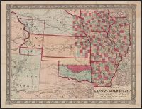
- Beinecke Rare Book and Manuscript Library > Johnson's new rail road and county copper plate map of Kansas gold region and the Great West, from the latest and best authorities.
- Creator:
- Warren, Gouverneur Kemble, 1830-1882
- Published / Created:
- 1855
- Call Number:
- 80gme 1855A
- Container / Volume:
- BRBL_00538
- Image Count:
- 1
- Resource Type:
- Maps, Atlases & Globes
- Found in:
- Beinecke Rare Book and Manuscript Library > Map of routes for a Pacific railroad : compiled to accompany the report of Hon. Jefferson Davis, Sec. of War / G.K. Warren.
- Creator:
- Blanchard, Rufus, 1821-1904
- Published / Created:
- 1868
- Call Number:
- 80gme 1868B
- Container / Volume:
- BRBL_00538
- Image Count:
- 1
- Resource Type:
- Maps, Atlases & Globes
- Found in:
- Beinecke Rare Book and Manuscript Library > Map of the Chicago, R.I. & Pacific R.R. : Chicago to Council Bluffs with its branches and western r.r. connections / engr. by Rufus Blanchard, Chicago, Ill.
- Creator:
- Newbery, F. T
- Published / Created:
- 1877?]
- Call Number:
- 80gme 1875
- Container / Volume:
- BRBL_00539
- Image Count:
- 1
- Resource Type:
- Maps, Atlases & Globes
- Found in:
- Beinecke Rare Book and Manuscript Library > Map of the Southern Pacific Rail Road and connections / F.T. Newbery, del.
- Creator:
- Palmer, William Jackson, 1836-1909
- Published / Created:
- 1868]
- Call Number:
- 80gme 1869A
- Container / Volume:
- BRBL_00538
- Image Count:
- 1
- Resource Type:
- Maps, Atlases & Globes
- Found in:
- Beinecke Rare Book and Manuscript Library > Map of the route of the Southern Continental R.R. with connections from Kansas City Mo., Ft. Smith Ark. and Shreveport La., giving a general view of the recent surveys of the Kansas Pacific Railway Co., across the continent / made in 1867 & 1868, under th
- Creator:
- Palmer, William Jackson, 1836-1909
- Published / Created:
- 1868]
- Call Number:
- 80gme 1868
- Container / Volume:
- BRBL_00538
- Image Count:
- 1
- Resource Type:
- Maps, Atlases & Globes
- Found in:
- Beinecke Rare Book and Manuscript Library > Map of the route of the Southern Continental R.R. with connections from Kansas City, Mo., Ft. Smith, Ark. and Shreveport, La. : giving a general view of recent surveys of the Kansas Pacific Railway Co. across the continent / made in 1867 & 1868 under the
- Creator:
- Warren, Gouverneur Kemble, 1830-1882
- Published / Created:
- 1858?]
- Call Number:
- 80 1857E
- Container / Volume:
- BRBL_00534
- Image Count:
- 2
- Resource Type:
- Maps, Atlases & Globes
- Found in:
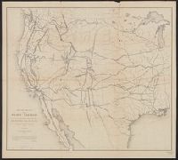
- Beinecke Rare Book and Manuscript Library > Map of the territory of the United States from the Mississippi to the Pacific Ocean : ordered by Jeff'n Davis, Secretary of War to accompany the reports of the explorations for a railroad route / compiled from authorized explorations and other reliable da
- Published / Created:
- [1928?]
- Call Number:
- 80gme 1928
- Container / Volume:
- BRBL_00540
- Image Count:
- 1
- Resource Type:
- Maps, Atlases & Globes
- Found in:
- Beinecke Rare Book and Manuscript Library > Map showing Northern Pacific Railway System, Chicago, Burlington & Quincy R.R. system, Spokane, Portland & Seattle Railway and its subsidiary lines ... Colorado & Southern Railway Lines ... [and] Trinity & Brazos Valley Railway.
- Published / Created:
- [1914?]
- Call Number:
- 80gme 1914A
- Container / Volume:
- BRBL_00540
- Image Count:
- 1
- Resource Type:
- Maps, Atlases & Globes
- Found in:
- Beinecke Rare Book and Manuscript Library > Map showing Northern Pacific Railway System, Chicago, Burlington & Quincy R.R. system, Spokane, Portland & Seattle Railway and its subsidiary lines ... Spokane & Inland Empire Railroad, Colorado & Southern Railway System, [and] Great Northern Pacific Stea
- Published / Created:
- [1912?]
- Call Number:
- 80gme 1912
- Container / Volume:
- BRBL_00540
- Image Count:
- 1
- Resource Type:
- Maps, Atlases & Globes
- Found in:
- Beinecke Rare Book and Manuscript Library > Map showing Northern Pacific Railway System, Chicago, Burlington & Quincy R.R. system, Spokane, Portland & Seattle Railway and its subsidiary lines ... Spokane & Inland Empire Railroad, [and] Colorado & Southern Railway System.
- Creator:
- G.W. & C.B. Colton & Co
- Published / Created:
- 1884
- Call Number:
- 80gme 1884
- Container / Volume:
- BRBL_00539
- Image Count:
- 1
- Resource Type:
- Maps, Atlases & Globes
- Found in:
- Beinecke Rare Book and Manuscript Library > Map showing the Union Pacific Railway and connecting railroads / prepared by G.W. & C.B. Colton & Co.
- Creator:
- G.W. & C.B. Colton & Co
- Published / Created:
- 1883
- Call Number:
- 80gme 1883B
- Container / Volume:
- BRBL_00539
- Image Count:
- 1
- Resource Type:
- Maps, Atlases & Globes
- Found in:
- Beinecke Rare Book and Manuscript Library > Map showing the Union Pacific Railway and connecting railroads / prepared by G.W. & C.B. Colton & Co.
- Creator:
- G.W. & C.B. Colton & Co
- Published / Created:
- 1885
- Call Number:
- 80gme 1885
- Container / Volume:
- BRBL_00539
- Image Count:
- 1
- Resource Type:
- Maps, Atlases & Globes
- Found in:
- Beinecke Rare Book and Manuscript Library > Map showing the Union Pacific Railway and connecting railroads / prepared by G.W. & C.B. Colton & Co.
- Creator:
- Rand McNally and Company
- Published / Created:
- [ca. 1874].
- Call Number:
- 75gme 1874
- Container / Volume:
- BRBL_00412
- Image Count:
- 1
- Resource Type:
- Maps, Atlases & Globes
- Found in:
- Beinecke Rare Book and Manuscript Library > New map of the American overland route : showing its connections, and land grants of 30,000,000 acres / engraved and published by Rand McNally & Co.
- Creator:
- Rand McNally and Company
- Published / Created:
- [1882?]
- Call Number:
- 75gme 1882A
- Container / Volume:
- BRBL_00413
- Image Count:
- 1
- Resource Type:
- Maps, Atlases & Globes
- Found in:
- Beinecke Rare Book and Manuscript Library > New map of the United States showing the complete railway system of the trans-Missouri country / prepared expressly for Crofutt's New overland tourist and Pacific coast guide, 1882, the Overland Publishing Company, Omaha, Neb., and Denver, Colo.
- Creator:
- Rand McNally and Company
- Published / Created:
- June 30th, 1904.
- Call Number:
- 80gme 1904A
- Container / Volume:
- BRBL_00540
- Image Count:
- 1
- Resource Type:
- Maps, Atlases & Globes
- Found in:
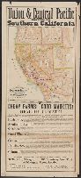
- Beinecke Rare Book and Manuscript Library > Rock Island-Frisco systems.
- Creator:
- Rand McNally and Company
- Published / Created:
- [1914]
- Call Number:
- 80gme 1914
- Container / Volume:
- BRBL_00540
- Image Count:
- 1
- Resource Type:
- Maps, Atlases & Globes
- Found in:
- Beinecke Rare Book and Manuscript Library > Southern Pacific Company and proprietary companies : 1914.
- Creator:
- Freyhold, Edward
- Published / Created:
- [1868]
- Call Number:
- 80 1868
- Container / Volume:
- BRBL_00535
- Image Count:
- 4
- Resource Type:
- Maps, Atlases & Globes
- Found in:
- Beinecke Rare Book and Manuscript Library > Territory of the United States from the Mississippi River to the Pacific Ocean : originally prepared to accompany the reports of the explorations for a Pacific railroad route / compiled from authorized explorations and other reliable data by G. K. Warren
- Creator:
- New England Railway Publishing Company
- Published / Created:
- c1902.
- Call Number:
- 75gme 1902B
- Container / Volume:
- BRBL_00414
- Image Count:
- 1
- Resource Type:
- Maps, Atlases & Globes
- Found in:
- Beinecke Rare Book and Manuscript Library > The ABC Pathfinder Railway Guide, Western Section / issued by the New England Railway Publishing Company.
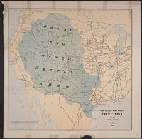
- Published / Created:
- 1885]
- Call Number:
- 80gc 1884
- Container / Volume:
- BRBL_00537
- Image Count:
- 1
- Resource Type:
- Maps, Atlases & Globes
- Found in:
- Beinecke Rare Book and Manuscript Library > The range and ranch cattle area of the United States : 1884.
- Creator:
- Nell, Louis
- Published / Created:
- 1868
- Call Number:
- 844gme 1868
- Container / Volume:
- BRBL_00619
- Image Count:
- 1
- Resource Type:
- Maps, Atlases & Globes
- Found in:
- Beinecke Rare Book and Manuscript Library > Topographical railroad & county map of the states of California and Nevada : compiled from the latest explorations and other official information / by L. Nell.
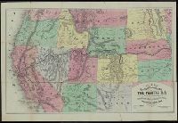
- Creator:
- Williams, Henry T
- Published / Created:
- [1876?]
- Call Number:
- 80gme 1876C
- Container / Volume:
- BRBL_00539
- Image Count:
- 2
- Resource Type:
- Maps, Atlases & Globes
- Found in:
- Beinecke Rare Book and Manuscript Library > Williams' new trans-continental map of the Pacific R.R. and routes of overland travel to Colorado, Nebraska, the Black Hills, Utah, Idaho, Nevada, Montana, California and the Pacific coast / Henry T. Williams.
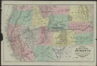
- Creator:
- Williams, Henry T
- Published / Created:
- [1877?]
- Call Number:
- 80gme 1877A
- Container / Volume:
- BRBL_00539
- Image Count:
- 2
- Resource Type:
- Maps, Atlases & Globes
- Found in:
- Beinecke Rare Book and Manuscript Library > Williams' new trans-continental map of the Pacific R.R. and routes of overland travel to Colorado, Nebraska, the Black Hills, Utah, Idaho, Nevada, Montana, California, and the Pacific coast.
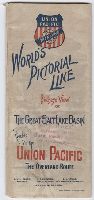
- Creator:
- Union Pacific Railway Company
- Published / Created:
- ca. 1893
- Call Number:
- Zc20 893wo
- Image Count:
- 9
- Resource Type:
- Books, Journals & Pamphlets
- Found in:
- Beinecke Rare Book and Manuscript Library > World’s pictorial line : birdseye view of the great Salt Lake Basin reached via the Union Pacific, the overland route
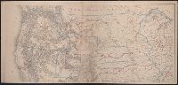
- Published / Created:
- between 1868 and 1889?]
- Call Number:
- 80 1900
- Container / Volume:
- BRBL_00536
- Image Count:
- 2
- Resource Type:
- Maps, Atlases & Globes
- Found in:
- Beinecke Rare Book and Manuscript Library > [Map of western United States showing military departments].