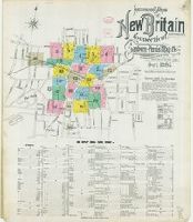
Sanborn fire insurance maps are a rich source of historic data on the urban built environment of North America during the 19th and early 20th centuries. The atlases were created for the purpose of underwriting fire insurance policies, which depended u...
Alternative Title:
New Britain, Hartford Co., Connecticut and Oct. 1895, New Britain, Conn.
Description:
"24 sheets. (8244)."
Subject (Geographic):
New Britain (Conn.)--Maps
Subject (Name):
Library of Congress Stamp
Subject (Topic):
Fire risk assessment--Connecticut--New Britain--Maps and Real property--Connecticut--New Britain--Maps
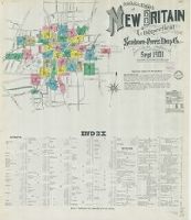
Sanborn fire insurance maps are a rich source of historic data on the urban built environment of North America during the 19th and early 20th centuries. The atlases were created for the purpose of underwriting fire insurance policies, which depended u...
Alternative Title:
New Britain, Hartford County, Connecticut and Sep. 1901, New Britain, Conn.
Description:
"35 sheets. (4915)."
Subject (Geographic):
New Britain (Conn.)--Maps
Subject (Name):
Library of Congress Stamp
Subject (Topic):
Fire risk assessment--Connecticut--New Britain--Maps and Real property--Connecticut--New Britain--Maps
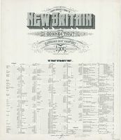
Sanborn fire insurance maps are a rich source of historic data on the urban built environment of North America during the 19th and early 20th centuries. The atlases were created for the purpose of underwriting fire insurance policies, which depended u...
Alternative Title:
New Britain, Conn. and New Britain, Hartford County, Connecticut
Description:
"52 sheets. (2003)."
Subject (Geographic):
New Britain (Conn.)--Maps
Subject (Name):
Library of Congress Stamp
Subject (Topic):
Fire risk assessment--Connecticut--New Britain--Maps and Real property--Connecticut--New Britain--Maps
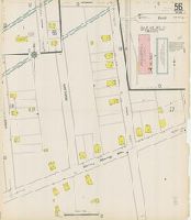
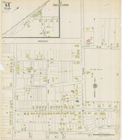
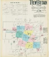
Sanborn fire insurance maps are a rich source of historic data on the urban built environment of North America during the 19th and early 20th centuries. The atlases were created for the purpose of underwriting fire insurance policies, which depended u...
Alternative Title:
July 1884, New Britain, Conn.
Description:
"12 sheets."
Subject (Geographic):
New Britain (Conn.)--Maps
Subject (Name):
Library of Congress Stamp
Subject (Topic):
Fire risk assessment--Connecticut--New Britain--Maps and Real property--Connecticut--New Britain--Maps
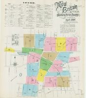
Sanborn fire insurance maps are a rich source of historic data on the urban built environment of North America during the 19th and early 20th centuries. The atlases were created for the purpose of underwriting fire insurance policies, which depended u...
Alternative Title:
April 1890, New Britain, Conn.
Description:
"19 sheets. (3742)."
Subject (Geographic):
New Britain (Conn.)--Maps
Subject (Name):
Library of Congress Ownership
Subject (Topic):
Fire risk assessment--Connecticut--New Britain--Maps and Real property--Connecticut--New Britain--Maps